Redland City
| Redland City Queensland | |||||||||||||||
|---|---|---|---|---|---|---|---|---|---|---|---|---|---|---|---|
 Location within South East Queensland | |||||||||||||||
| Population | 156,863 (2018)[1] (46th) | ||||||||||||||
| • Density | 292.001/km2 (756.28/sq mi) | ||||||||||||||
| Established | 1948 | ||||||||||||||
| Area | 537.2 km2 (207.4 sq mi)[1] | ||||||||||||||
| Mayor | Karen Williams | ||||||||||||||
| Council seat | Cleveland | ||||||||||||||
| Region | South East Queensland | ||||||||||||||
| State electorate(s) |
| ||||||||||||||
| Federal Division(s) | Bowman | ||||||||||||||
 | |||||||||||||||
| Website | Redland City | ||||||||||||||
| |||||||||||||||
Redland City, better known as the Redlands and formerly known as Redland Shire, is a local government area and a part of the Brisbane metropolitan area in South East Queensland. With a population of 156,863 in June 2018, the City is spread along the southern coast of Moreton Bay, covering 537.2 square kilometres (207.4 sq mi). Its mainland borders the City of Brisbane to the west and north-west, and Logan City to the south-west and south, while its islands are situated north of the City of Gold Coast.
Redland attained city status on 15 March 2008, having been a shire since 1949, when it was created by the merger of the former Tingalpa and Cleveland Shires.[2] Despite this status, the City consists of largely suburban and coastal communities, featuring a somewhat disjointed urbanisation around major suburbs interspersed with bushland; there is no clear city centre.
Large mainland suburbs include Capalaba, Cleveland, Victoria Point, and Redland Bay. The latter is the City's namesake, due to the colour of its fertile soil.[3] North Stradbroke Island and smaller nearby islands, most notably those of Southern Moreton Bay, comprise the eastern portion of the Redlands. The City's boundaries correspond to those of the federal division of Bowman.
History[]

The area now known as the Redlands was initially inhabited by the Jagera, Turrbal, and Quandamooka people.[4] Some locations derive their names from Aboriginal languages, and known historic sites within the area include a bora ring at Mount Cotton.[5][6] The Quandamooka are recognised as the traditional custodians of North Stradbroke Island, and more recently applied for native title over much of the Redlands' surrounding islands and mainland.[7][8] Jandai (also known as Janday, Jandewal, Djendewal, Jundai, Goenpul and Jandawal), one of the Aboriginal languages of the Moreton Bay Region, has a language region centred on Stradbroke Island, which falls within the local government boundaries of Redland City Council.[9]
Europeans first entered the Redlands in the late 18th century while mapping Moreton Bay: James Cook made observations of the then-undivided Stradbroke Island; Matthew Flinders landed on Coochiemudlo Island in 1799; and Robert Dixon later surveyed and named much of the area.
By the 1840s, the coastal township of Cleveland was in contention to become a major port replacing Brisbane, but was ultimately not chosen due to the region's existing sandbars and shipwrecks, and an unfavourable review from Governor George Gipps during his 1842 visit. Louis Hope and other land purchasers began to develop significant infrastructure at this time. On 11 November 1879, under the Divisional Boards Act 1879, the Tingalpa Division was created to govern the area to the east of metropolitan Brisbane. The area around Cleveland split away to form the Cleveland Division on 30 May 1885. Under the Local Authorities Act 1902, both became Shires on 31 March 1903. The Tingalpa council met at Mount Cotton.
On 1 October 1925, a sizeable portion of the Shire of Tingalpa (suburbs west of Tingalpa Creek, including Upper Mount Gravatt and Rochedale) became part of the new City of Brisbane along with 20 other local governments.[10][11] On 9 December 1948, as part of a major reorganisation of local government in South East Queensland, an Order in Council renamed the Shire of Cleveland to be Shire of Redland and amalgamated part of Shire of Tingalpa into it (the other part of Tingalpa amalgamated to form the Shire of Albert).[12]
The twentieth century saw significant population growth in the Redlands, preceded by the construction of the Cleveland railway line. Peel Island became a leper colony, while North Stradbroke Island became a hub for sand mining, and is also associated with the Indigenous rights movement as the home of poet Oodgeroo Noonuccal and academic Aileen Moreton-Robinson. On 15 March 2008, Redlands was granted city status.[13][14]
In June 2018, the Redland City Council approved a marketing campaign to brand the city as "Redlands Coast" with the tagline "naturally wonderful". The campaign seeks to attract tourists to the city's 335 kilometres (208 mi) of coastline (due to a number of islands which form part of the city).[15]
Geography[]
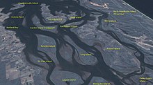
Although most of the population resides on the main urban conglomeration based around the centres of Capalaba, Cleveland and Victoria Point, over 6,000 people live on islands in Moreton Bay that are part of the City. These are North Stradbroke, Coochiemudlo and the Southern Moreton Bay Islands of Karragarra, Lamb, Russell and Macleay. Tingalpa Creek rises on Mount Cotton, forming Leslie Harrison Dam, and marking the majority of the area's western boundary.[16]
Environment[]
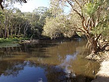
Redland City has many immediately recognisable animals and plants such as koalas, migratory shorebirds, flying foxes and scribbly gum forests. It is also home to over 1,700 other recorded native species, many of which are under threat from population growth and its associated effects such as habitat clearing and fragmentation, road construction, pollution and expanding development.[17] The council area is also home to Venman Bushland National Park, and the Eprapah Scout environment training centre.

In April 2013, the Redland City Council illegally cleared vegetation from public land on the foreshores of Moreton Bay. The Council has been required by the State Government to restore the cleared vegetation and install signage about the restoration.[18] Trees felled included many sheoaks.[19]
The city's koala population has declined significantly in recent years. In 2010, it was estimated that only 2,000 koalas remained, a 65% decline since 1999. Figures from a count in 2012 have not yet been released by the Queensland Government.[20] The Redland City-based Koala Action Group has warned that: "Rampant expansion of urban areas will lead to the loss of the koala populations that are vital to the long-term survival of the species."[21]
The city boundaries include internationally significant coastal wetlands within the Moreton Bay Ramsar site. Tidal flats, mangroves and seagrass beds provide important habitats for fish, crustaceans, and:
- large numbers of the nationally threatened green turtle and the loggerhead turtle
- the internationally vulnerable dugong, a large sea mammal from the order Sirenia which also includes manatee species
- 43 species of shorebirds, including 30 migratory bird species listed by international migratory bird conservation agreements, such as the vulnerable eastern curlew and the grey-tailed tattler, that use this area in their journey through the East Asian–Australasian Flyway.[22][23][24]
Freshwater systems in the Redlands catchment do not meet set ecosystem health values, according to the Healthy Waterways Report Cards for both 2013 and 2014.[25][26]
Fire ants have been detected in a number of Redland City suburbs, with Sheldon and Mount Cotton being assessed by BioSecurity Queensland as high-risk, and requiring treatment by ground teams.[27]
Transport[]

Queensland Rail operates the Cleveland railway line, which connects the Redlands with Brisbane as part of its City network. The line runs parallel with the Brisbane River to its south, passing through Brisbane's Cannon Hill and Wynnum, before crossing Tingalpa Creek to enter Redland City. Northern suburbs of the City are serviced by five stations: Thorneside, Birkdale, Wellington Point, Ormiston, and Cleveland, where the line terminates.
The TransLink (South East Queensland) bus network is prevalent in the Redlands. Bus stations at Capalaba and Victoria Point feature regular city-bound and outbound connections, with direct services to Carindale, Eight Mile Plains, Loganholme, and the Brisbane CBD during peak hour. Upon pending completion, the Eastern Busway is expected to terminate at Capalaba bus station.[28][29]
The and are located further west within the City of Brisbane. Major roads are accessible from these highways, such as Old Cleveland Road, Mount Gravatt-Capalaba Road, and Mount Cotton Road, which enter the Redlands from Chandler, Burbank, and Cornubia, respectively.
Culture and heritage[]

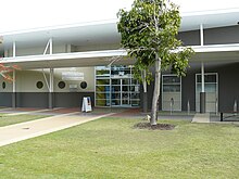
Redland City has a number of important cultural facilities, including the Redland Art Gallery, Redland Museum, and Redland Performing Arts Centre.
The City also has many heritage-listed sites,[30] including:
- Multiple historic sites of Cleveland, such as the Cleveland Point Light,[31] Old Cleveland Police Station, Cleveland Pioneer Cemetery, Grand View Hotel, and the historic pine trees near the Point
- The church, public hall, causeway and public reserve in Dunwich, North Stradbroke Island
- Whepstead Manor at Wellington Point
- The Industrial Ruins on Macleay Island
- The Ormiston House Estate and Fellmongery
- Serpentine Creek Road Cemetery in Redland Bay.
Economy[]

For the year ending 30 June 2014, Redland City's Gross Regional Product (GRP) was estimated to be 4.77 billion dollars.[32]
| Year (Ending June) | Redland City – % Change in GRP | Queensland – % Change in GRP |
| 2014 | 1.7 | 1.7 |
| 2013 | 1.7 | 2.6 |
| 2012 | 5.0 | 6.2 |
| 2011 | 1.6 | 0.7 |
| 2010 | 2.0 | 0.0 |
| 2009 | 1.0 | 0.6 |

Key industry sectors include health care and social assistance, retail trade, education and training, sand mining, construction and tourism.
During the year ending in June 2014, an estimated 41,506 jobs were located in Redland City,[33] along with an estimated 74,089 employed residents,[34] meaning 32,035 (or 47.1%) of Redland City’s employed residents who work travel outside of the area to do so.[35]
| Year (Ending June) | Redland City – Employed Residents | Redland City – Local Jobs |
| 2014 | 74,089 | 41,506 |
| 2013 | 74,141 | 41,788 |
| 2012 | 74,633 | 43,138 |
| 2011 | 73,863 | 43,485 |
| 2010 | 73,033 | 42,888 |
| 2009 | 73,207 | 41,829 |
Mining[]

North Stradbroke Island, one of the world's largest sand islands, has been the subject of sand mining operations since 1949.[36] In 2010, Queensland's Labor Government announced a phase-out of the sand mining industry over a 17-year period, with up to 80% of the island to be covered by national park. In April 2011, the government then extended key expired mining leases to allow mining to continue at the main Enterprise sand mine until the end of 2019, while was interested in an extension to 2027.[37] 2013 saw the LNP Government pass legislation allowing sand mining on the island for an extra 16 years: from 2019 to 2035.[38] For mining to continue past 2019 at the Enterprise sand mine, the lease owner (currently ) would have to apply for an extension in 2019, under legislative amendments passed by the Newman Government in November 2013. However, if the amendments are repealed by a future government before 2019, the mine will close on 31 December 2019, the closure date legislated by the government in April 2011.[39]
The circumstances leading up to this legislative amendment have been referred to Queensland's Crime and Misconduct Commission.[40] On 6 June 2014, North Stradbroke Island's traditional owners, the Quandamooka people, initiated a legal challenge saying, on the grounds that the LNP Government's extension of mining contravened the Federal Native Title Act.[41] In May 2016, legislation passed by the Palaszczuk Ministry did confirm that sand mining on North Stradbroke will end by 2019.[42][43]
Mainland quarries are located in the suburb of Mount Cotton,[44][45] and have drawn their own criticisms concerning allegations of pollution[46] and OHS breaches.[47]
Development[]

Toondah Harbour in Cleveland is the location of the Stradbroke Island Ferry Terminal, used by water taxis and vehicular ferries to provide access to North Stradbroke Island. Cleveland's Toondah Harbour and Redland Bay's Weinam Creek were declared Priority Development Areas (PDAs) under the Economic Development Act 2012 on 21 June 2013. PDA designation allows development to be fast-tracked, but also means that local communities and interest groups have less opportunity to comment on issues of concern.[48]
The Government and Redland City Council have proposed PDA development schemes which have attracted community opposition. On 23 February, approximately 30 people attended a rally to protest against the Government's plans to "carve up" the G.J. Walter Park as part of its Toondah Harbour redevelopment proposal.[49] On 4 March 2014 a petition with 1,211 signatures calling for the Government's Toondah Harbour PDA plan to be withdrawn was tabled in the Queensland Parliament.[50]
On 31 May 2014, an approved development scheme was released[51] together with a lengthy report on the 583 submissions received during the consultation period.[52]
On 18 September 2014, the Government and Council announced that Walker Corporation had been selected as preferred developer for both the Toondah Harbour and Weinam Creek priority development areas.[53]
Local government[]
Redland City Council has a Mayor, and a Councillor for each of its 10 divisions.[54] Elections are held every four years and voting is compulsory.
Karen Williams was elected mayor at the 2012 election. She pledged to cap rate rises to inflation, control debt, abolish fees to dump rubbish at local tips, and make the council more transparent and accountable.[55]
Williams was re-elected at the 2016 local government election and the 2020 local government elections.[56][57]
| Councillor | Declared political membership | Term | Constituency | |
|---|---|---|---|---|
| Cr. Karen Williams | Independent | 2012–present | Mayor | [57] |
| Cr. Wendy Boglary | Independent | 2008–present | Division 1 | [57] |
| Cr. Peter Mitchell | Independent | 2016–present | Division 2 | [57] |
| Cr. Paul Gollè | Independent | 2016–present | Division 3 | [57] |
| Cr. Lance Hewlett | Independent | 2012–present | Division 4 | [57] |
| Cr. Mark Edwards | Independent | 2012–present | Division 5 | [57] |
| Cr. Julie Talty | Independent | 2012–present | Division 6 | [57] |
| Cr. Rowanne McKenzie | Independent | 2020–present | Division 7 | [57] |
| Cr. Tracey Huges | ALP | 2016–present | Division 8 | [57] |
| Cr. Adelia Berridge | Independent | 2020–present | Division 9 | [57] |
| Cr. Paul Bishop | Independent | 2012–present | Division 10 | [57] |
Suburbs[]
Redland City consists of the following suburbs and localities:[58]


|
|
Redland City also includes a number of uninhabited or sparsely populated islands in Moreton Bay, including:[59]
- Peel Island
- Cassim Island, near Cleveland: a low-lying area of mangroves with seagrass around it which provides a high value habitat for wading birds and other fauna,[60] named after William Cassim, an early Cleveland hotel keeper.[61]
Chairmen and mayors[]
This section needs expansion. You can help by . (June 2016) |
- 1961– : Ernest Gaden Western Wood (for seven consecutive terms)[62]
- 2012–present: Karen Williams[63]
Other notable members of the Redland Council include:
Demographics[]
According to the 2016 census,[65] the population of the Redlands was 147,010. The median age was 41 years old, 3 years older than the nationwide median. The male-to-female ratio was 49-to-51.
The most commonly nominated ancestries were English (32.1%), Australian (25.2%), Irish (9.0%), Scottish (8.6%), and German (4.5%). 72.5% of people were born in Australia, while the other most common countries of birth were England (6.7%), New Zealand (5.4%), South Africa (1.7%), Scotland (0.9%), and the Philippines (0.5%). Indigenous Australians accounted for 2.3% of the population.
The most commonly spoken languages other than English were Afrikaans and Mandarin (0.5% each), German (0.4%), and Italian and Spanish (0.3% each). The most common religious affiliations reported were none (29.8%), Catholic (21.1%), Anglican (17.9%), and Uniting Church (6.1%).
Population[]

The following table lists of the population of Redland City and its predecessor local government areas:.[citation needed]
| Year | Population |
|---|---|
| 1947 | 5,211 |
| 1954 | 7,365 |
| 1961 | 10000 |
| 1966 | 12,632 |
| 1971 | 16,672 |
| 1976 | 27,539 |
| 1981 | 42,527 |
| 1986 | 58,501 |
| 1991 | 80,690 |
| 1996 | 100,101 |
| 2001 | 117,252 |
| 2006 | 131,210 |
| 2012 | 145,336 |
| 2016 | 147,010 |
| 2020 | 160,331 |
Libraries[]
The Redland City Council operate public libraries at Amity Point, Capalaba, Cleveland, Dunwich, Point Lookout, Russell Island and Victoria Point.[66] There is a mobile library serving Alexandra Hills, Mount Cotton Park, Redland Bay, Thorneside, Victoria Point, and Wellington Point.[67]
References[]
- ^ Jump up to: a b "3218.0 – Regional Population Growth, Australia, 2017–18: Population Estimates by Local Government Area (ASGS 2018), 2017 to 2018". Australian Bureau of Statistics. Australian Bureau of Statistics. 27 March 2019. Archived from the original on 27 March 2019. Retrieved 25 October 2019. Estimated resident population, 30 June 2018.
- ^ Queensland State Archives, Search for Agency Details of Redland City Council Archived 27 January 2014 at the Wayback Machine, Retrieved 7 April 2014
- ^ David Tuffley, 2007, "Redland Bay, Australia: Introduction", Griffith University: "Archived copy". Archived from the original on 24 September 2015. Retrieved 6 September 2015.CS1 maint: archived copy as title (link), Retrieved 7 September 2015
- ^ https://aboriginalspirituality12re.wordpress.com/information-on-the-turrbal-and-jagera-people/
- ^ https://www.redland.qld.gov.au/info/20163/quandamooka_country/594/aboriginal_cultural_heritage_in_the_redlands
- ^ https://www.rochedalehistory.com.au/aboriginal-history
- ^ https://quandamookacoast.com.au/about/quandamooka-country-map/
- ^ http://www.qyac.net.au/NativeTitle.html
- ^ "Queensland Aboriginal and Torres Strait Islander languages map". State Library of Queensland. 2020. Archived from the original on 5 September 2020. Retrieved 23 January 2020.
- ^ Queensland Places, "Tingalpa", Centre for the Government of Queensland, University of Queensland: "Archived copy". Archived from the original on 22 February 2015. Retrieved 22 February 2015.CS1 maint: archived copy as title (link), Retrieved 19 May 2015
- ^ City of Brisbane Act 1924 Archived 13 March 2011 at the Wayback Machine (accessed 19 May 2015)
- ^ Queensland Places, "Redland City", Centre for the Government of Queensland, University of Queensland: "Archived copy". Archived from the original on 20 May 2015. Retrieved 19 May 2015.CS1 maint: archived copy as title (link), Retrieved 19 May 2015
- ^ Redland City Council, "Redlands City Community Plan Project Proposal", 18 March 2008: "Archived copy" (PDF). Archived (PDF) from the original on 12 April 2015. Retrieved 19 May 2015.CS1 maint: archived copy as title (link), Retrieved 19 May 2015
- ^ The Redland Foundation, "About Us": "Archived copy". Archived from the original on 20 May 2015. Retrieved 19 May 2015.CS1 maint: archived copy as title (link), Retrieved 19 May 2015
- ^ "Redland City Council approves Redlands Coast brand and naturally wonderful tagline". Redland City Bulletin. 6 June 2018. Archived from the original on 28 August 2018. Retrieved 16 September 2018.
- ^ Mary Howells, "Living on the Edge: along Tingalpa Creek a history of Upper Tingalpa, Capalaba and Thorneside", University of Queensland, 2001: "Archived copy" (PDF). Archived (PDF) from the original on 20 May 2015. Retrieved 17 July 2015.CS1 maint: archived copy as title (link), Retrieved 19 May 2015
- ^ Biodiversity Strategy 2008–2012, Redland City Council, May 2008: "Archived copy". Archived from the original on 22 February 2014. Retrieved 22 February 2014.CS1 maint: archived copy as title (link), Retrieved on 5 February 2014
- ^ Judith Kerr, "Council guilty of illegal tree clearing", Redland City Bulletin, 26 July 2014: "Archived copy". Archived from the original on 27 July 2014. Retrieved 26 July 2014.CS1 maint: archived copy as title (link), Retrieved 27 July 2014
- ^ "Wildlife Bayside,"Council cleared protected coastal vegetation for individual ocean views?" Retrieved 27 July 2014". Archived from the original on 13 August 2014. Retrieved 26 July 2014.
- ^ Tony Moore, "State Government's go-slow on Koala Coast population figures", Brisbane Times, 9 December 2013 Archived 1 March 2014 at the Wayback Machine, Retrieved on 9 March 2014
- ^ KAG comments on Draft EPBC Act Referral Guidelines for the Vulnerable Koala: "Archived copy". Archived from the original on 13 March 2014. Retrieved 12 March 2014.CS1 maint: archived copy as title (link), Retrieved on 13 March 2014
- ^ "Moreton Bay (Ramsar Site) Overview, Australian Government, Department of The Environment Retrieved on 5 February 2014". Archived from the original on 13 February 2014. Retrieved 5 February 2014.
- ^ Migratory waterbirds, Australian Government, Department of The Environment Archived 22 February 2014 at the Wayback Machine, Retrieved 13 February 2014
- ^ BAAM Ecological Consultants and FRC Environmental, "Expert Advice in Ecology (Marine and Terrestrial)and Coastal Processes for Input to the preparation of a Structure Plan and Development Scheme for Toondah Harbour and Weinam Creek Priority Development Areas":"Archived copy" (PDF). Archived (PDF) from the original on 5 May 2014. Retrieved 5 May 2014.CS1 maint: archived copy as title (link), Retrieved 5 May 2014
- ^ James Kelly, "Moreton Bay's grade falls in Healthy Waterways report", ABC News, 23 October 2013: "Archived copy". Archived from the original on 10 March 2014. Retrieved 8 March 2014.CS1 maint: archived copy as title (link), Retrieved on 8 March 2014
- ^ Judith Kerr, "Water report gives Redland 'F' for fail", Redland City Bulletin, 22 October 2014: "Archived copy". Archived from the original on 22 October 2014. Retrieved 22 October 2014.CS1 maint: archived copy as title (link), Retrieved 22 October 2014
- ^ Judith Kerr, "Fire ants on the march in Redlands", Bayside Bulletin, 20 June 2013: "Archived copy". Archived from the original on 9 March 2014. Retrieved 9 March 2014.CS1 maint: archived copy as title (link), Retrieved on 9 March 2014
- ^ "Eastern Busway". TransLink. Archived from the original on 21 July 2015. Retrieved 17 July 2015.
- ^ "Revitalisation of the Coorparoo Junction Precinct". Anissa Farrell, Sourceable. 27 May 2015. Archived from the original on 21 July 2015. Retrieved 17 July 2015.
- ^ The External links section of this article includes a link to a search of the Queensland Heritage Register which gives a complete list of all heritage-listed places in Redland City.
- ^ "Cleveland Lighthouse (former) (entry 600772)". Queensland Heritage Register. Queensland Heritage Council. Retrieved 12 July 2013.
- ^ .Id, Redland City Gross Product: "Archived copy". Archived from the original on 8 April 2014. Retrieved 7 April 2014.CS1 maint: archived copy as title (link), Retrieved 18 May 2015
- ^ Id, Redland City, Local Jobs: "Archived copy". Archived from the original on 18 May 2015. Retrieved 18 May 2015.CS1 maint: archived copy as title (link), Retrieved 18 May 2015
- ^ Id, Redland City, Employed Residents: "Archived copy". Archived from the original on 4 March 2016. Retrieved 18 May 2015.CS1 maint: archived copy as title (link), Retrieved 18 May 2015
- ^ Id, Redland City, Residents place of work by occupation – All occupations: "Archived copy". Archived from the original on 6 November 2016. Retrieved 18 May 2015.CS1 maint: archived copy as title (link)?, Retrieved 18 May 2015
- ^ Queensland Historical Atlas, Mining: "Archived copy". Archived from the original on 24 April 2014. Retrieved 7 April 2014.CS1 maint: archived copy as title (link) , Retrieved 7 April 2014
- ^ Courtney Trenwith, "Green jobs to replace mining work on Stradbroke: Bligh", Brisbane Times, 21 June 2010:"Archived copy". Archived from the original on 8 January 2014. Retrieved 7 April 2014.CS1 maint: archived copy as title (link) , Retrieved 7 April 2014
- ^ Judith Kerr, "Straddie Act amended to allow 16 more years of mining", Bayside Bulletin, 21 November 2013: "Archived copy". Archived from the original on 8 April 2014. Retrieved 7 April 2014.CS1 maint: archived copy as title (link) , Retrieved 7 April 2014
- ^ Richard Carew, "The government is lying about Stradbroke Island sand mining", Brisbane times, 15 July 2014 Archived 18 July 2014 at the Wayback Machine, Retrieved 15 July 2014
- ^ Tony Moore, "Labor refers Sibelco sand mining company to CMC", Brisbane Times, 24 June 2014:"Archived copy". Archived from the original on 27 June 2014. Retrieved 29 June 2014.CS1 maint: archived copy as title (link), retrieved 29 June 2014
- ^ "Native title dispute goes to court after Queensland mining lease extended", The Guardian, 6 June 2014 Archived 21 May 2017 at the Wayback Machine, Retrieved 6 June 2014
- ^ Gail Burke (26 May 2016). "North Stradbroke Island sand mining to end by 2019". ABC. Archived from the original on 8 June 2016. Retrieved 8 June 2016.
- ^ Trenton Akers (26 May 2016). "Sand mining on North Stradbroke Island to end in 2019". The Courier-Mail. Retrieved 8 June 2016.
- ^ "About Us – Mt Cotton Quarries". Mt Cotton Quarries. Archived from the original on 9 January 2016. Retrieved 2 November 2015.
- ^ "About Us – Karreman Quarries". Karreman Quarries. Archived from the original on 23 March 2016. Retrieved 2 November 2015.
- ^ Mark Solomons and Mark Willacy (25 February 2015). "Karreman Quarries accused of illegally dumping chemicals and waste oils at Mount Cotton quarry, company denies allegations". ABC News. Archived from the original on 7 November 2015. Retrieved 2 November 2015.
- ^ "Dane Karreman, 9, banned from driving 30-tonne front-end loader". news.com.au. 2 November 2009. Archived from the original on 30 June 2014. Retrieved 11 September 2015.
- ^ Economic Development Act 2014 (Qld): "Archived copy" (PDF). Archived (PDF) from the original on 7 April 2014. Retrieved 1 April 2014.CS1 maint: archived copy as title (link) , Retrieved 1 April 2014
- ^ "Future of GJ Walter Park defines Toondah debate", Bayside Bulletin, 24 February 2014, "Archived copy". Archived from the original on 28 February 2014. Retrieved 24 February 2014.CS1 maint: archived copy as title (link), Retrieved on 25 February 2014
- ^ Judith Kerr, "Parliament hears petition demanding new Toondah plan", Bayside Bulletin, 6 March 2014: "Archived copy". Archived from the original on 8 March 2014. Retrieved 8 March 2014.CS1 maint: archived copy as title (link), Retrieved on 8 March 2014
- ^ Toondah Harbour Priority Development Area Development Scheme May 2014: "Archived copy" (PDF). Archived (PDF) from the original on 10 April 2015. Retrieved 1 June 2014.CS1 maint: archived copy as title (link), Retrieved 1 June 2014
- ^ Toondah Harbour Priority Development Area Development Scheme Submissions Report, May 2014: "Archived copy" (PDF). Archived (PDF) from the original on 10 April 2015. Retrieved 1 June 2014.CS1 maint: archived copy as title (link), Retrieved 1 June 2014
- ^ Judith Kerr, "Walker Group to develop Cleveland and Redland bay waterfronts", Redland City Bulletin, 18 September 2014: "Archived copy". Archived from the original on 24 September 2015. Retrieved 18 May 2015.CS1 maint: archived copy as title (link), Retrieved on 18 May 2015
- ^ "Mayor & Councillors". Redland City Council. Queensland Government. Archived from the original on 1 March 2017. Retrieved 19 March 2018.
- ^ Daniel Hurst, "Redland voters ponder change at the top", Brisbane Times, 26 April 2012: "Archived copy". Archived from the original on 16 March 2014. Retrieved 20 February 2014.CS1 maint: archived copy as title (link) , Retrieved 21 February 2014
- ^ "Council election wash-up". ABC. 21 March 2016. Archived from the original on 24 June 2016. Retrieved 8 June 2016.
- ^ Jump up to: a b c d e f g h i j k l "2020 Local Government Elections: Saturday, 28 March 2020". Electoral Commission of Queensland. 2020. Retrieved 16 June 2020.[dead link]
- ^ "Our Suburbs". Redland City Council. Archived from the original on 14 November 2013. Retrieved 10 September 2013.
- ^ "Redland (C)" (PDF). Queensland Local Government Areas (LGA), 2011. Queensland Government. Archived (PDF) from the original on 29 October 2013. Retrieved 28 October 2013.
- ^ Peter Davie et al, "Wild Guide To Moreton Bay", Queensland Museum, 1998, p 376
- ^ Joshua Peter Bell, "Moreton Bay And How To Fathom It", Queensland Newspapers, 1984, p 52
- ^ "Wood, Ernest Gaden Western, MBE (Dick)". Former Members. Queensland Parliament. Archived from the original on 3 August 2016. Retrieved 3 April 2021.
- ^ "The Mayor". Redland City Council. Archived from the original on 15 March 2021. Retrieved 3 April 2021.
- ^ "Goleby, Mr John Philip". Re-Member Database. Queensland Parliament. Archived from the original on 12 March 2016. Retrieved 18 June 2014.
- ^ "2016 Census QuickStats: Redland (C)". quickstats.censusdata.abs.gov.au. Archived from the original on 28 July 2019. Retrieved 28 July 2019.
- ^ "Library opening hours and locations". Redland City Council. Archived from the original on 30 January 2018. Retrieved 31 January 2018.
- ^ "Mobile Library". Redland City Council. Archived from the original on 30 January 2018. Retrieved 31 January 2018.
Further reading[]
- Kidd, Barry (1979), Redlands Illustrated History, B. Kidd, ISBN 978-0-9595110-0-0
- Townsend, Derek (1986), Redlands: The Story of an Australian Shire, WD, ISBN 978-0-947074-00-5
External links[]
![]() Media related to Redland City at Wikimedia Commons
Media related to Redland City at Wikimedia Commons
- Redland City Council
- University of Queensland: Queensland Places: Redland City
- Queensland Government Department of Environment and Heritage Protection, Results of Search for Queensland Heritage Listed Places in Redland City
Coordinates: 27°35′35.86″S 153°15′59.11″E / 27.5932944°S 153.2664194°E

- Populated places established in 1948
- 1948 establishments in Australia
- Redland City
- Local government areas in Brisbane
- Coastal cities in Australia
- Local government areas of Queensland