Calera, Alabama
Calera | |
|---|---|
| Calera, Alabama | |
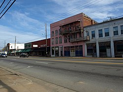 The Calera Downtown Historic District was listed on the National Register of Historic Places on March 29, 2006. | |
 Location of Calera in Chilton County and Shelby County, Alabama. | |
 Calera Location in the United States | |
| Coordinates: 33°06′10″N 86°45′13″W / 33.10278°N 86.75361°WCoordinates: 33°06′10″N 86°45′13″W / 33.10278°N 86.75361°W | |
| Country | United States |
| State | Alabama |
| Counties | Chilton, Shelby |
| Government | |
| • Mayor | Jon G. Graham |
| Area | |
| • Total | 24.43 sq mi (63.28 km2) |
| • Land | 24.17 sq mi (62.59 km2) |
| • Water | 0.27 sq mi (0.69 km2) |
| Population | |
| • Total | 11,620 |
| • Estimate (2019)[1] | 14,717 |
| • Density | 608.95/sq mi (235.12/km2) |
| Time zone | UTC-6 (CST) |
| • Summer (DST) | UTC-5 (CDT) |
| ZIP code | 35040[3] |
| Area code(s) | 205, 659 |
| FIPS code | 01-11416 |
| Website | www |

Calera is a city in Shelby and Chilton counties in the U.S. state of Alabama. It is the location of the Shelby County Airport.
As of the 2010 census Calera had a population of 11,620, more than tripling its total in 2000,[5] making it the fastest-growing city in Alabama. It is within the Birmingham-Hoover, Alabama Metropolitan Statistical Area.
Geography[]
Calera is located in southern Shelby County at 33°06′27″N 86°45′00″W / 33.107572°N 86.749964°W.[6] The city limits extend southward into Chilton County along U.S. Route 31, the main highway through the city. Interstate 65 passes through the eastern side of the city, with access from exits 228, 231, and 234. Birmingham is 34 mi (55 km) north, and Montgomery is 59 mi (95 km) south, both via I-65.
According to the United States Census Bureau, the city has a total area of 24.4 square miles (63.1 km2), of which 24.1 square miles (62.4 km2) is land and 0.27 square miles (0.7 km2), or 1.17%, is water.[5]
History[]
The city of Calera was incorporated in 1887, and named after the Spanish word for "quarry" for all of the limestone deposits located in the area.
Demographics[]
| Historical population | |||
|---|---|---|---|
| Census | Pop. | %± | |
| 1880 | 234 | — | |
| 1890 | 753 | 221.8% | |
| 1900 | 770 | 2.3% | |
| 1910 | 754 | −2.1% | |
| 1920 | 852 | 13.0% | |
| 1930 | 975 | 14.4% | |
| 1940 | 1,092 | 12.0% | |
| 1950 | 1,361 | 24.6% | |
| 1960 | 1,928 | 41.7% | |
| 1970 | 1,655 | −14.2% | |
| 1980 | 2,035 | 23.0% | |
| 1990 | 2,136 | 5.0% | |
| 2000 | 3,158 | 47.8% | |
| 2010 | 11,620 | 268.0% | |
| 2019 (est.) | 14,717 | [1] | 26.7% |
As of the census[8] of 2000, there were 3,158 people, 1,248 households, and 888 families living in the city. The population density was 244.9 people per square mile (94.5/km2). There were 1,400 housing units at an average density of 108.6 per square mile (41.9/km2). The racial makeup of the city was 77.42% White, 19.92% Black or African American, 0.19% Native American, 0.54% Asian, 0.06% Pacific Islander, 0.66% from other races, and 1.20% from two or more races. 1.90% of the population were Hispanic or Latino of any race.
Of the 1,248 households 33.0% had children under the age of 18 living with them, 54.1% were married couples living together, 13.5% had a female householder with no husband present, and 28.8% were non-families. 26.4% of households were one person and 10.8% were one person aged 65 or older. The average household size was 2.51 and the average family size was 3.04.
The age distribution was 26.7% under the age of 18, 8.2% from 18 to 24, 31.7% from 25 to 44, 20.9% from 45 to 64, and 12.5% 65 or older. The median age was 34 years. For every 100 females, there were 93.0 males. For every 100 females age 18 and over, there were 85.0 males.
The median household income was $35,650 and the median family income was $42,885. Males had a median income of $34,042 versus $21,750 for females. The per capita income for the city was $16,395. About 12.2% of families and 12.5% of the population were below the poverty line, including 15.8% of those under age 18 and 3.2% of those age 65 or over.
2010 census[]
As of the census[9] of 2010, there were 11,620 people, 4,657 households, and 3,240 families living in the city. The population density was 482.2 people per square mile (186.2/km2). There were 5,128 housing units at an average density of 212.8 per square mile (82.2/km2). The racial makeup of the city was 71.2% White, 23.0% Black or African American, 0.2% Native American, 0.6% Asian, 0% Pacific Islander, 2.9% from other races, and 2.0% from two or more races. 5.0% of the population were Hispanic or Latino of any race.
Of the 4,657 households 35.4% had children under the age of 18 living with them, 53.8% were married couples living together, 12.3% had a female householder with no husband present, and 30.4% were non-families. 25.9% of households were one person and 5.2% were one person aged 65 or older. The average household size was 2.49 and the average family size was 3.01.
The age distribution was 26.5% under the age of 18, 7.4% from 18 to 24, 39.5% from 25 to 44, 18.5% from 45 to 64, and 8.0% 65 or older. The median age was 31.9 years. For every 100 females, there were 92.0 males. For every 100 females age 18 and over, there were 87.7 males.
The median household income was $54,080 and the median family income was $62,117. Males had a median income of $47,125 versus $37,888 for females. The per capita income for the city was $24,391. About 9.6% of families and 12.6% of the population were below the poverty line, including 18.9% of those under age 18 and 7.8% of those age 65 or over.
Notable people[]
- Shanavia Dowdell, professional basketball player
- Hut Stricklin, NASCAR driver
- Virgil Trucks, Major League Baseball pitcher
Points of interest[]
- Shelby County Airport
- Oliver Park
- Heart of Dixie Railroad Museum
- Peek's Auto Tops and Interiors
- George Roy Park
- Timberline Golf Course
- Calera Presbyterian Church
- Ozan Winery
- Vizzini Winery
Gallery[]
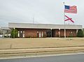
Calera City Hall

The Calera Presbyterian Church was built in 1885. The church building is now owned by the city. It was added to the Alabama Register of Landmarks and Heritage on March 12, 1997.
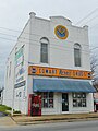
The Cowart Drug Store was built in 1885. It was added to the Alabama Register of Landmarks and Heritage on February 15, 1977.


Climate[]
The climate in this area is characterized by hot, humid summers and generally mild to cool winters. According to the Köppen Climate Classification system, Calera has a humid subtropical climate, abbreviated "Cfa" on climate maps. Calera is the location of the National Weather Service forecast office that serves the Birmingham metropolitan area.[10] [11]
| hideClimate data for Calera, Alabama | |||||||||||||
|---|---|---|---|---|---|---|---|---|---|---|---|---|---|
| Month | Jan | Feb | Mar | Apr | May | Jun | Jul | Aug | Sep | Oct | Nov | Dec | Year |
| Average high °C (°F) | 12 (54) |
16 (60) |
19 (67) |
25 (77) |
28 (83) |
32 (89) |
33 (92) |
33 (91) |
30 (86) |
25 (77) |
19 (66) |
14 (58) |
24 (75) |
| Average low °C (°F) | −1 (31) |
1 (33) |
5 (41) |
9 (48) |
13 (55) |
17 (63) |
19 (67) |
19 (66) |
16 (61) |
9 (48) |
4 (39) |
1 (33) |
9 (49) |
| Average precipitation mm (inches) | 130 (5.1) |
130 (5.3) |
170 (6.5) |
130 (5.2) |
100 (4) |
110 (4.2) |
140 (5.4) |
110 (4.2) |
97 (3.8) |
71 (2.8) |
94 (3.7) |
130 (5.1) |
1,400 (55.1) |
| Source: Weatherbase [12] | |||||||||||||
References[]
- ^ Jump up to: a b "Population and Housing Unit Estimates". United States Census Bureau. May 24, 2020. Retrieved May 27, 2020.
- ^ "U.S. Census website". United States Census Bureau. Retrieved May 29, 2018.
- ^ "Zipdatamaps". Retrieved 2016-10-30.
- ^ "2019 U.S. Gazetteer Files". United States Census Bureau. Retrieved June 29, 2020.
- ^ Jump up to: a b "Geographic Identifiers: 2010 Demographic Profile Data (G001): Calera city, Alabama". U.S. Census Bureau, American Factfinder. Archived from the original on February 12, 2020. Retrieved June 3, 2014.
- ^ "US Gazetteer files: 2010, 2000, and 1990". United States Census Bureau. 2011-02-12. Retrieved 2011-04-23.
- ^ "Census of Population and Housing". Census.gov. Retrieved June 4, 2016.
- ^ "U.S. Census website". United States Census Bureau. Retrieved 2008-01-31.
- ^ "U.S. Census website". United States Census Bureau. Retrieved 2015-08-08.
- ^ "NWS Birmingham, Alabama". June 20, 2020.
- ^ Climate Summary for Calera, Alabama
- ^ "Weatherbase.com". Weatherbase. 2013. Retrieved on November 6, 2013.
External links[]
| show Municipalities and communities of Chilton County, Alabama, United States |
|---|

| show Municipalities and communities of Shelby County, Alabama, United States |
|---|

| show Authority control |
|---|
- Cities in Alabama
- Cities in Chilton County, Alabama
- Cities in Shelby County, Alabama
- Populated places established in 1887
- Birmingham metropolitan area, Alabama
- 1887 establishments in Alabama