Camp Hill, Alabama
Camp Hill, Alabama | |
|---|---|
 Camp Hill in 2021 | |
 Location of Camp Hill in Tallapoosa County, Alabama. | |
| Coordinates: 32°47′57″N 85°39′10″W / 32.79917°N 85.65278°W | |
| Country | United States |
| State | Alabama |
| County | Tallapoosa |
| Area | |
| • Total | 9.09 sq mi (23.54 km2) |
| • Land | 8.99 sq mi (23.28 km2) |
| • Water | 0.10 sq mi (0.26 km2) |
| Elevation | 712 ft (217 m) |
| Population (2010) | |
| • Total | 1,014 |
| • Estimate (2019)[1] | 950 |
| • Density | 105.67/sq mi (40.80/km2) |
| Time zone | UTC-6 (Central (CST)) |
| • Summer (DST) | UTC-5 (CDT) |
| ZIP code | 36850 |
| Area code(s) | 256 |
| FIPS code | 01-11680 |
| GNIS feature ID | 0115465 |

Camp Hill is a town in Tallapoosa County, Alabama, United States. It was incorporated in 1895.[3] At the 2010 census the population was 1,014, down from 1,273 in 2000. Camp Hill is the home to Southern Preparatory Academy (formerly known as "Lyman Ward Military Academy").
History[]
On July 15, 1931, a white mob, lead by Tallapoosa County sheriff Kyle Young and Camp Hill police chief J. M. Wilson--who voiced his desire to “kill every member of the ‘Reds’ there and throw them into the creek,” raided a meeting of the Alabama Sharecroppers' Union which was being held in a church in Camp Hill.[4] A shootout between the mob and union members followed; SCU member Ralph Gray was murdered, his home burned, and his burned corpse was dumped on the courthouse steps. Dozens of black men and women were killed, lynched or injured, and at least thirty sharecroppers were later arrested.[4] According to Hosea Hudson, all those arrested were eventually released without trial due to public and international pressure—albeit too late to have a chance at raising a crop that year.[5]
Geography[]
Camp Hill is located at 32°47′57″N 85°39′10″W / 32.79917°N 85.65278°W (32.799285, -85.652902).[6]
According to the U.S. Census Bureau, the town has a total area of 9.1 square miles (24 km2), of which 9.1 square miles (24 km2) is land and 0.11% is water.
The town is located in the east central part of the state along U.S. Route 280 and Alabama State Route 50. U.S. 280 runs along the southwestern boundary of the town, leading southeast 21 mi (34 km) to Opelika and northwest 8 mi (13 km) to Dadeville, the Tallapoosa County seat. AL-50 runs through the center of town, leading northeast 18 mi (29 km) to LaFayette and southwest 24 mi (39 km) to the unincorporated community of Red Hill in Elmore County. Birmingham is 92 mi (148 km) northwest via U.S. 280.
Demographics[]
| Historical population | |||
|---|---|---|---|
| Census | Pop. | %± | |
| 1890 | 366 | — | |
| 1900 | 686 | 87.4% | |
| 1910 | 896 | 30.6% | |
| 1920 | 952 | 6.3% | |
| 1930 | 1,131 | 18.8% | |
| 1940 | 1,147 | 1.4% | |
| 1950 | 1,296 | 13.0% | |
| 1960 | 1,270 | −2.0% | |
| 1970 | 1,554 | 22.4% | |
| 1980 | 1,628 | 4.8% | |
| 1990 | 1,415 | −13.1% | |
| 2000 | 1,273 | −10.0% | |
| 2010 | 1,014 | −20.3% | |
| 2019 (est.) | 950 | [1] | −6.3% |
| U.S. Decennial Census[7] 2013 Estimate[8] | |||
At the 2000 census there were 1,273 people, 519 households, and 337 families in the town. The population density was 140.4 people per square mile (54.2/km2). There were 614 housing units at an average density of 67.7 per square mile (26.1/km2). The racial makeup of the town was 84.92% Black or African American, 14.38% White, 0.31% from other races, and 0.39% from two or more races. 1.02% of the population were Hispanic or Latino of any race.[9] Of the 519 households 30.3% had children under the age of 18 living with them, 29.5% were married couples living together, 30.1% had a female householder with no husband present, and 34.9% were non-families. 33.3% of households were one person and 12.7% were one person aged 65 or older. The average household size was 2.45 and the average family size was 3.09.
The age distribution was 29.4% under the age of 18, 8.9% from 18 to 24, 27.0% from 25 to 44, 22.2% from 45 to 64, and 12.6% 65 or older. The median age was 36 years. For every 100 females, there were 82.4 males. For every 100 females age 18 and over, there were 77.3 males.
The median household income was $20,655 and the median family income was $26,719. Males had a median income of $22,833 versus $20,038 for females. The per capita income for the town was $11,794. About 21.0% of families and 24.4% of the population were below the poverty line, including 34.8% of those under age 18 and 31.5% of those age 65 or over.
2010 census[]
At the 2010 census there were 1,014 people, 450 households, and 269 families in the town. The population density was 111.4 people per square mile (43.1/km2). There were 581 housing units at an average density of 63.8 per square mile (24.7/km2). The racial makeup of the town was 88.4% Black or African American, 10.2% White, 0.5% from other races, and 0.8% from two or more races. .7% of the population were Hispanic or Latino of any race.[10] Of the 450 households 21.8% had children under the age of 18 living with them, 26.9% were married couples living together, 28.7% had a female householder with no husband present, and 40.2% were non-families. 36.9% of households were one person and 12.0% were one person aged 65 or older. The average household size was 2.25 and the average family size was 2.96.
The age distribution was 22.1% under the age of 18, 10.1% from 18 to 24, 20.7% from 25 to 44, 32.6% from 45 to 64, and 14.5% 65 or older. The median age was 41.8 years. For every 100 females, there were 77.9 males. For every 100 females age 18 and over, there were 81.6 males.
The median household income was $18,663 and the median family income was $23,646. Males had a median income of $27,083 versus $16,694 for females. The per capita income for the town was $12,627. About 37.2% of families and 38.6% of the population were below the poverty line, including 55.8% of those under age 18 and 31.3% of those age 65 or over.
Notable person[]
- Bill Higdon, former Major League Baseball player
Gallery[]
Camp Hill Town Hall

Camp Hill Post Office (ZIP code: 36850)

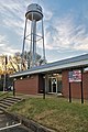
Camp Hill Volunteer Fire Department
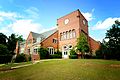
Camp Hill is home to Southern Preparatory Academy. It was formerly known as "Lyman Ward Military Academy". Tallapoosa Hall (pictured) was completed in 1930 with the help of Booker T. Washington and employees of Tuskegee University. It was added to the Alabama Register of Landmarks and Heritage on January 24, 2008.[11]

The First Universalist Church of Camp Hill was designed by Birmingham architect Daniel A. Helmich and built in 1907 using indigenous material. It was added to the Alabama Register of Landmarks and Heritage on March 13, 1996.

The Winter's Grocery Building in Camp Hill


Climate[]
The climate in this area is characterized by hot, humid summers and generally mild to cool winters. According to the Köppen Climate Classification system, Camp Hill has a humid subtropical climate, abbreviated "Cfa" on climate maps. [12]
| hideClimate data for Camp Hill, Alabama | |||||||||||||
|---|---|---|---|---|---|---|---|---|---|---|---|---|---|
| Month | Jan | Feb | Mar | Apr | May | Jun | Jul | Aug | Sep | Oct | Nov | Dec | Year |
| Average high °C (°F) | 14 (57) |
16 (60) |
19 (67) |
24 (76) |
28 (83) |
32 (89) |
33 (91) |
32 (90) |
31 (87) |
25 (77) |
19 (67) |
14 (58) |
24 (75) |
| Average low °C (°F) | 1 (34) |
2 (35) |
6 (42) |
9 (49) |
14 (57) |
18 (65) |
19 (67) |
19 (67) |
17 (62) |
10 (50) |
4 (40) |
2 (35) |
10 (50) |
| Average precipitation mm (inches) | 130 (5.1) |
130 (5.1) |
150 (6.1) |
120 (4.7) |
94 (3.7) |
99 (3.9) |
130 (5.3) |
110 (4.3) |
91 (3.6) |
69 (2.7) |
84 (3.3) |
130 (5.2) |
1,340 (52.9) |
| Source: Weatherbase [13] | |||||||||||||
References[]
- ^ Jump up to: a b "Population and Housing Unit Estimates". United States Census Bureau. May 24, 2020. Retrieved May 27, 2020.
- ^ "2019 U.S. Gazetteer Files". United States Census Bureau. Retrieved June 29, 2020.
- ^ http://www.encyclopediaofalabama.org/article/h-3420
- ^ Jump up to: a b Hudson, Hosea (1972). Black Worker in the Deep South: A Personal Record. New York: International Publishers. pp. 35–36.
- ^ Black Worker in the Deep South, at 35-36.
- ^ "US Gazetteer files: 2010, 2000, and 1990". United States Census Bureau. 2011-02-12. Retrieved 2011-04-23.
- ^ "U.S. Decennial Census". Census.gov. Retrieved June 6, 2013.
- ^ "Annual Estimates of the Resident Population: April 1, 2010 to July 1, 2013". Archived from the original on May 22, 2014. Retrieved June 3, 2014.
- ^ "U.S. Census website". United States Census Bureau. Retrieved 2008-01-31.
- ^ "U.S. Census website". United States Census Bureau. Retrieved 2015-08-12.
- ^ "The Architecture of Tallapoosa Hall". Southern Prep Academy. Retrieved 19 April 2021.
- ^ Climate Summary for Camp Hill, Alabama
- ^ "Weatherbase.com". Weatherbase. 2013. Retrieved on November 6, 2013.
Coordinates: 32°47′57″N 85°39′10″W / 32.799285°N 85.652902°W
| show Municipalities and communities of Tallapoosa County, Alabama, United States |
|---|

| show Authority control |
|---|
- Towns in Tallapoosa County, Alabama
- Towns in Alabama
- Alexander City micropolitan area