Canet, Aude
This article may be expanded with text translated from the corresponding article in French. (December 2008) Click [show] for important translation instructions.
|
Canet | |
|---|---|
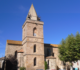 The church in Canet | |
 Coat of arms | |
Location of Canet  | |
 Canet  Canet | |
| Coordinates: 43°13′47″N 2°50′52″E / 43.2297°N 2.8478°ECoordinates: 43°13′47″N 2°50′52″E / 43.2297°N 2.8478°E | |
| Country | France |
| Region | Occitanie |
| Department | Aude |
| Arrondissement | Narbonne |
| Canton | Le Sud-Minervois |
| Intercommunality | Région Lézignanaise, Corbières et Minervois |
| Government | |
| • Mayor (2020–2026) | André Hernandez[1] |
| Area 1 | 14.04 km2 (5.42 sq mi) |
| Population (Jan. 2018)[2] | 1,812 |
| • Density | 130/km2 (330/sq mi) |
| Time zone | UTC+01:00 (CET) |
| • Summer (DST) | UTC+02:00 (CEST) |
| INSEE/Postal code | 11067 /11200 |
| Elevation | 18–37 m (59–121 ft) (avg. 30 m or 98 ft) |
| 1 French Land Register data, which excludes lakes, ponds, glaciers > 1 km2 (0.386 sq mi or 247 acres) and river estuaries. | |
Canet is a commune in the Aude department in southern France.
Population[]
| Year | Pop. | ±% |
|---|---|---|
| 1962 | 1,029 | — |
| 1968 | 1,030 | +0.1% |
| 1975 | 910 | −11.7% |
| 1982 | 837 | −8.0% |
| 1990 | 939 | +12.2% |
| 1999 | 1,072 | +14.2% |
| 2008 | 1,244 | +16.0% |
See also[]
- Corbières AOC
- Communes of the Aude department
References[]
- ^ "Répertoire national des élus: les maires". data.gouv.fr, Plateforme ouverte des données publiques françaises (in French). 2 December 2020.
- ^ "Populations légales 2018". INSEE. 28 December 2020.
| Wikimedia Commons has media related to Canet, Aude. |
Authority control | |
|---|---|
| General |
|
| National libraries | |
This Aude geographical article is a stub. You can help Wikipedia by . |
Categories:
- Communes of Aude
- Aude geography stubs