Cape Tappi
| Cape Tappi | |
|---|---|
| 竜飛崎 | |
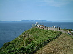 Cape Tappi with Hokkaido in the distance | |
 Location of Cape Tappi in Aomori Prefecture | |
| Location | Sotogahama, Aomori, Japan |
| Coordinates | 41°15′34″N 140°20′34″E / 41.25944°N 140.34278°ECoordinates: 41°15′34″N 140°20′34″E / 41.25944°N 140.34278°E |
| Surface elevation | 0 m |


Cape Tappi (竜飛崎, Tappizaki), otherwise known as Cape Tappimi (龍飛崎, Tappimisaki),[1] is a headland on the northernwestern point of the island of Honshu in Japan. It is located on the northern tip of the Tsugaru Peninsula within the borders of the town of Sotogahama in Aomori Prefecture. Much of the cape is also a part of the Tsugaru Quasi-National Park.[2] The cape marks the western limit of the Tsugaru Strait, separating it from the Sea of Japan. The area is known for its almost constant strong winds.
The cape's Tappizaki Lighthouse is listed as one of the “50 Lighthouses of Japan” by the Japan Lighthouse Association.[3] Near the lighthouse are stone monuments commemorating a number of people associated with Aomori Prefecture, including the author Osamu Dazai. On clear days, Matsumae Peninsula in Hokkaido across the Tsugaru Strait can be seen from this location.
References[]
- ^ 国土地理院の地形図 [Geospatial Information Authority Topographic Map] (Map) (in Japanese). Geospatial Information Authority of Japan. Retrieved 14 February 2020.
- ^ 公園計画図~津軽国定公園~ 2-11 [Tsugaru Quasi-National Park Limits- Map 2-11] (PDF) (Map) (in Japanese). Retrieved 14 February 2020.
- ^ Japan Lighthouse Association home page (in Japanese)
External links[]
| Wikimedia Commons has media related to Cape Tappi. |
| Authority control |
|
|---|
This Aomori Prefecture location article is a stub. You can help Wikipedia by . |
- Sotogahama, Aomori
- Landforms of Aomori Prefecture
- Tourist attractions in Aomori Prefecture
- Headlands of Japan
- Aomori geography stubs