Cape to Cairo Road
 | |
|---|---|
 | |
| Highway system | |
|
|

The Cape to Cairo Road or Pan-African Highway, sometimes called the Great North Kenya in sub-Saharan Africa, was a proposed road that would stretch the length of Africa, from Cape Town to Cairo, through the Cape to Cairo Red Line of British colonies. The proposal was similar to the Cape to Cairo Railway, another proposed infrastructure project through the same colonies. Neither were completed before British colonial rule ended in the colonies.
In the 1980s the plan was revived with modifications as the Cairo–Cape Town Highway, known as Trans-African Highway 4, in the transcontinental road network being developed by the United Nations Economic Commission for Africa (UNECA), the African Development Bank (ADB), and the African Union, as part of the Trans-African Highway network.
History[]
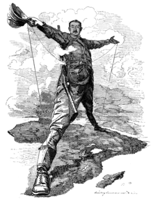
From about 1890,[citation needed] some[who?] in the British Empire envisioned a road that would stretch across the continent from south to north, running through the British colonies of the time, such as the Union of South Africa, Southern and Northern Rhodesia and Nyasaland, Kenya, Sudan and Egypt. The road would create cohesion between the British colonies of Africa, it was thought, and give Britain the most important and dominant political and economic influence over the continent, securing its position as a global colonial power. The road would also link some of the most important cities on the continent, including Cape Town, Johannesburg, Pretoria, Harare (then Salisbury), Lusaka (the main street through the centre of Lusaka was part of this route and is how it got its name, Cairo Road), Nairobi, Khartoum and Cairo. One of the main proponents of the route was Cecil John Rhodes, though his preference was for a railway.[1] German East Africa (Tanganyika, now Tanzania) was a gap in the British territories, but Rhodes, in particular, felt that Germany ought to be a natural ally. Shortly before his death he had persuaded the German Kaiser to allow access through his colony for the Cape to Cairo telegraph line (which was built as far north as Ujiji but never completed).[2] In 1918 Tanganyika became British and the gap in territories was filled.
One of the biggest problems was the decline of the Empire and fragmentation of the British colonies. Even though Egypt became independent in 1922, British influence there was strong enough for Cairo to be viewed as part of the British sphere of interest,[citation needed] and the idea of a road continued. After Egypt, Sudan was the next to become independent in 1956,[citation needed] putting an end to the colonial motivation of the dream.
France had a rival strategy in the late 1890s to link its colonies from west to east across the continent, Senegal to Djibouti. Southern Sudan and Ethiopia were in the way, but France sent expeditions in 1897 to establish a protectorate in southern Sudan and to find a route across Ethiopia. The scheme foundered when a British flotilla on the Nile confronted the French expedition at the point of intersection between the French and British routes, leading to the Fashoda Incident and eventual diplomatic defeat for France.
The first known attempt to drive a vehicle from Cape Town to Cairo was by a Captain Kelsey in 1913-14 but this came to an untimely end when he was killed by a leopard in Rhodesia. The first successful journey was Court Treatt expedition of 1924 led by Major Chaplin Court Treatt and described by his wife Stella Court Treatt in Cape to Cairo (1927), which drove two Crossley light trucks leaving Cape Town on 23 September 1924 and arriving in Cairo on 24 January 1926.[3][4]
The original route today[]
Starting from the south, the first section of the road that runs through South Africa is called the N1, linking Cape Town in the south with Beit Bridge on the Limpopo River between South Africa and Zimbabwe. It passes through Johannesburg and Pretoria. There are numerous alternative routes in South Africa, including a route through Mahikeng and Gaborone, as an alternative to reach Zimbabwe.
In Zimbabwe, the road continues as the Chirundu-Beitbridge Regional Road Corridor, which consists of the A4 road (R1 road) to Harare and the A1 road (R3 road) to Chirundu Border Post on the Zambezi River thereafter, continuing as the T2 Road in Zambia to Lusaka. An alternative route is the A6 and A8 roads, which connect the South African Border with the Zambian Border at Victoria Falls on the Zambezi River via Bulawayo. The alternative route continues as the T1 Road in Zambia towards Lusaka.
From Lusaka, Zambia's Great North Road continues the route to Tanzania as the T2 Road. (No alternative route; Also known as the Tanzam Highway and consisting of a right turn at Kapiri Mposhi towards Tanzania)
In Tanzania there are a number of roads could be deemed to be part of the route, the clear definitions and markings that are characteristic of the Pan-African Highway do not apply here. Most would consider it to be the road from Tunduma on the Tanzania-Zambia border, through Morogoro to the Arusha turnoff, and north through Dodoma to Arusha, then to Nairobi in Kenya. This route is now all paved. There was a marker in the 1930s in Arusha, Tanzania, to indicate the midpoint of the road.[5] The entire route through Tanzania from Tunduma on the Zambian Border to the Kenya Border is designated as the A104 Road.
Kenya has a tarred highway to its border with Sudan but the roads in southern Sudan are very poor and made frequently impassable, so that even without the conflicts that have afflicted Sudan, the route through Ethiopia is generally preferred by overland travellers. The route from Isiolo in Kenya to Moyale on the Ethiopian border through the northern Kenyan desert has sometimes been dangerous due to bandits, but is now paved.
Through Ethiopia the route is tarred but some sections may have deteriorated severely. A paved road from Lake Tana to Gedaref takes the route into Sudan.[6][7]
The most difficult section in the whole Cape to Cairo journey was across the Nubian Desert in northern Sudan between Atbara and Wadi Halfa, but this has been bypassed by a paved road on the west side of the Nile, Dongola-Abu Simbel Junction-Aswan.[8] Tarred highways continue the route to Cairo. As a result, the Cape to Cairo Road is fully paved.[contradictory]
Cairo–Cape Town Highway[]
The Cairo–Cape Town Highway follows much of the Cape-to-Cairo Road's route but it has a few differences.
Firstly, the Cairo–Cape Town Highway passes through Addis Ababa, Ethiopia while the Cape-to-Cairo Road goes directly through South Sudan from Kenya. Secondly, the Cairo–Cape Town Highway passes through Livingstone (Victoria Falls), Bulawayo, Francistown and Gaborone and not through Harare, Pretoria and Johannesburg.
This new route has a length of 10,228 km.[9] As South Sudan has a paved link to its border with Kenya, ultimately a route through southern Sudan via Khartoum and South Sudan may provide a shorter alternative to the Ethiopian route.[citation needed]
The modern revival of the plan occurred in the 1980s. South Africa was not originally included in the route which was first planned in the Apartheid era, but it is now recognized that it would continue into that country. The consultants' report suggested Pretoria as end, which seems somewhat arbitrary and as a major port, Cape Town, is regarded as the southern end of regional highways in Southern African Development Community countries. The highway may be referred to in documents as the Cairo–Gaborone Highway or Cairo–Pretoria Highway.
As the Cairo-Cape Town Highway passes through south-eastern Botswana, the route does not pass through Pretoria as the Cape-to-Cairo Road does. After Gaborone, the road proceeds into the western side of South Africa
See also[]
- Cape to Cairo (disambiguation)
- Cape to Cairo Railway
- Cape to Cairo Red Line
- The Rhodes Colossus
- Scramble for Africa
- Fashoda Incident
- North–South Corridor Project
References[]
- ^ "Cape to Cairo Railway".
- ^ Denny, S. R. (1962). "The Cape to Cairo Telegraph". The Northern Rhodesia Journal. 5 (1): 39–42. Retrieved 15 April 2007 – via NRZAM.
- ^ Court Treatt, Stella (1927). Cape to Cairo. London: Harrap.
- ^ "The Court Treatt Expedition". Retrieved 22 May 2009.
- ^ Matson Photo Service. "Tanganyika. Arusha. Half-way point from Cape to Cairo, 1936" (Photograph) – via Library of Congress.
- ^ Michelin Maps. 745 Africa North East & Arabia (Map). 1:4,000,000.[full citation needed]
- ^ Michelin Maps. 746 Africa Central & South, Madagascar (Map). 1:4,000,000.[full citation needed]
- ^ https://www.horizonsunlimited.com/hubb/north-africa/sudan-egypt-via-argeen-west-91827
- ^ "Cairo-Cape Town Highway: From Vision to Reality in 2015". Egyptian Streets. ES Media. 12 September 2014. Retrieved 25 January 2015.
Bibliography[]
- African Development Bank; United Nations Economic Commission For Africa (14 August 2003). "Volume 2: Description of Corridors" (PDF). Review of the Implementation Status of the Trans African Highways and the Missing Links. Archived from the original (PDF) on 28 January 2007. Retrieved 14 July 2007.
- Michelin Maps (2000). "Africa Central and South" (Map). Michelin Motoring and Tourist Map. Paris: Michelin Travel Publications.[full citation needed]
| hide | ||
|---|---|---|
| East-West |
|  |
| North-South |
| |
- British Empire
- Road transport in Africa
- Trans-African Highway network