Capendu
show This article may be expanded with text translated from the corresponding article in French. (December 2008) Click [show] for important translation instructions. |
Capendu | |
|---|---|
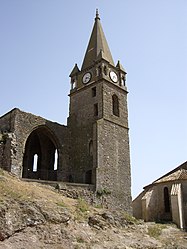 Ruins of the chateau | |
 Coat of arms | |
show Location of Capendu | |
 Capendu | |
| Coordinates: 43°11′06″N 2°33′37″E / 43.185°N 2.5603°ECoordinates: 43°11′06″N 2°33′37″E / 43.185°N 2.5603°E | |
| Country | France |
| Region | Occitanie |
| Department | Aude |
| Arrondissement | Carcassonne |
| Canton | La Montagne d'Alaric |
| Intercommunality | Carcassonne Agglo |
| Government | |
| • Mayor (2020–2026) | Claude Busto |
| Area 1 | 15.12 km2 (5.84 sq mi) |
| Population (Jan. 2018)[1] | 1,473 |
| • Density | 97/km2 (250/sq mi) |
| Time zone | UTC+01:00 (CET) |
| • Summer (DST) | UTC+02:00 (CEST) |
| INSEE/Postal code | 11068 /11700 |
| Elevation | 59–461 m (194–1,512 ft) (avg. 83 m or 272 ft) |
| 1 French Land Register data, which excludes lakes, ponds, glaciers > 1 km2 (0.386 sq mi or 247 acres) and river estuaries. | |


Capendu (French pronunciation: [kapɑ̃dy] (![]() listen); Occitan: Campendut) is a commune in the Aude department in southern France.
listen); Occitan: Campendut) is a commune in the Aude department in southern France.
Etymology[]
Mentioned in the form Campendud 1071. Occitan “sloping field”, “inclined field”. Fortuitous homophony with Capendu, hamlet of Blainville-Crevon (Seine-Maritime) which means “hung cat”. Armorial bearings
History[]
One finds potteries dating about 20.000 years ago in the Mayrac locality. The traces reveal a Roman camp site near the placement of the windmill of Roque Del Die (Occitan for Rock of God).
Population[]
| Year | Pop. | ±% |
|---|---|---|
| 1962 | 1,407 | — |
| 1968 | 1,413 | +0.4% |
| 1975 | 1,160 | −17.9% |
| 1982 | 1,198 | +3.3% |
| 1990 | 1,291 | +7.8% |
| 1999 | 1,380 | +6.9% |
| 2008 | 1,525 | +10.5% |
Events[]
For seven years, FestiVoix, organized by the community of communes, has invited choral societies and artists.
See also[]
- Corbières AOC
- Communes of the Aude department
References[]
- ^ "Populations légales 2018". INSEE. 28 December 2020.
| Wikimedia Commons has media related to Capendu. |
| show Communes of the Aude department |
|---|
| show Authority control |
|---|
This Aude geographical article is a stub. You can help Wikipedia by . |
Categories:
- Communes of Aude
- Aude geography stubs