Capitancillo Island
 Capitancillo Islet, Bogo, Cebu | |
 Capitancillo Location within the Philippines | |
| Geography | |
|---|---|
| Location | Visayan Sea |
| Coordinates | 10°59′25″N 124°06′14″E / 10.9903°N 124.1039°ECoordinates: 10°59′25″N 124°06′14″E / 10.9903°N 124.1039°E |
| Archipelago | Central Visayas |
| Adjacent bodies of water | Camotes Sea |
| Area | 600 ha (1,500 acres) |
| Highest elevation | 4.5 m (14.8 ft)[1] |
| Administration | |
| Province | Cebu |
| City | Bogo |
| Barangay | Odlot |
| Demographics | |
| Population | uninhabited |
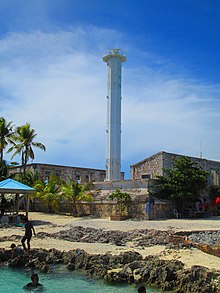
| Capitancillo Island Lighthouse | |
 | |
| Constructed | 1905 |
| Tower height | 25 m (82 ft), 83 ft (25 m) |
| First lit | 1990, 1905 |
| Focal height | 30 m (98 ft), 98 ft (30 m) |
| Range | 15 nmi (28 km; 17 mi) |
| Characteristic | Fl(3) W 10s |
| Admiralty no. | F2406 |
| NGA no. | 112-14800 |
| ARLHS no. | PHI034 |


Capitancillo (historically Islote de Captitoncillo and variously Capitancillo islet) is a small coral island (about 600 hectares in size) near Bogo City, Cebu, Philippines. The island is a protected marine sanctuary, featuring three dive sites and a lighthouse.
Location and geography[]
Capitancillo is a small uninhabited island northeast of Cebu Island in the Camotes Sea. It is 6.1 kilometres (3.8 mi) east of Odlot barangay, Bogo City. Three areas around the island (the Ormoc Shoal, the Nuñez Shoal, and the southwest wall of Capitancillo) are recognized dive sites. Polambato Port, Nailon Wharf, Marangog Cove, and Odlot Hideaway all serve as jumping-off points to the island from Bogo, and the trip takes anywhere from fifteen to 45 minutes. There are no stores nor accommodation available on the island.[2]
Folklore[]
Legends surrounding the island state that Capitancillo was named after Captain Basillo, the captain of a Spanish trading vessel. According to the legends, Captain Basillo insulted a local datu, named Bugtopasan. Bugtopasan cursed Captain Basillo and put a spell on him, transforming the Captain's galleon into the island.[3]
Lighthouse[]
The original lighthouse was listed in the Faros Españoles de Ultramar as one of 27 major lighthouses of the Philippines.[4][5] The Capitancillo lighthouse was built in 1905, with the current white steel tower dating from the 1950s. The tower is 83 feet (25 m) high and flashes three white lights every ten seconds.[6]
See also[]
- Lighthouses in the Philippines
- List of islands in the Philippines
- List of islands
- Desert island
References[]
- ^ National Geospatial-Intelligence Agency 2008
- ^ Philippine Daily Inquirer 2011
- ^ "The Legend of Capitancillo". The Bogo Times. Retrieved 7 July 2014.
- ^ Sánchez Terry 1992
- ^ Rowlett 2016
- ^ Lighthouse Explorer 2014
Sources[]
- Lighthouse Explorer (2014). "Capitancillo Island Light". Archived from the original on 14 July 2014.
- National Geospatial-Intelligence Agency (2008). Sailing Directions (Enroute) Philippine Islands (PDF) (7th ed.). p. 183. Archived from the original on 2 April 2013.CS1 maint: unfit URL (link)
- Philippine Daily Inquirer (12 August 2011). "Capitancillo: Cebu's new ocean leisure spot". Archived from the original on 13 August 2011. Retrieved 7 July 2014.
- Rowlett, Russ (2016). "Spanish Lighthouses of the Philippines". The Lighthouse Directory. University of North Carolina at Chapel Hill.
- Sánchez Terry, Miguel Angel (1992). Faros Españoles de Ultramar. Madrid: Ministerio de Obras Públicas y Transportes (MOPT). ISBN 978-8474337921.
External links[]
- Islands of Cebu
- Uninhabited islands of the Philippines
- Bogo, Cebu