Castellarano
Castellarano | |
|---|---|
| Comune di Castellarano | |
 | |
show Location of Castellarano | |
 Castellarano Location of Castellarano in Italy | |
| Coordinates: 44°34′N 10°47′E / 44.567°N 10.783°ECoordinates: 44°34′N 10°47′E / 44.567°N 10.783°E | |
| Country | Italy |
| Region | Emilia-Romagna |
| Province | Reggio Emilia (RE) |
| Frazioni | Ca' de Grimaldi, Ca' de Ravazzini, Cadiroggio, Case Ferri, Castello La Croce, Farneto di Sotto, Le Ville, Montebabbio, Pradivia, Roteglia, Scuole, Telarolo, San Valentino, Tressano, Ca De Fi, |
| Government | |
| • Mayor | Giorgio Zanni |
| Area | |
| • Total | 58.06 km2 (22.42 sq mi) |
| Elevation | 149 m (489 ft) |
| Population (31 December 2017)[3] | |
| • Total | 15,326 |
| • Density | 260/km2 (680/sq mi) |
| Demonym(s) | Castellaranesi |
| Time zone | UTC+1 (CET) |
| • Summer (DST) | UTC+2 (CEST) |
| Postal code | 42014 |
| Dialing code | 0536 |
| Website | Official website |


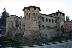
Castellarano (Reggiano: Castlarân) is a comune (municipality) in the Province of Reggio Emilia in the Italian region Emilia-Romagna, located about 45 kilometres (28 mi) west of Bologna and about 20 kilometres (12 mi) southeast of Reggio Emilia.
Castellarano borders the following municipalities: Baiso, Casalgrande, Prignano sulla Secchia, Sassuolo, Scandiano, Viano.
References[]
- ^ "Superficie di Comuni Province e Regioni italiane al 9 ottobre 2011". Istat. Retrieved 16 March 2019.
- ^ "Popolazione Residente al 1° Gennaio 2018". Istat. Retrieved 16 March 2019.
- ^ All demographics and other statistics: Italian statistical institute Istat.
External links[]
| show Authority control |
|---|
Categories:
- Cities and towns in Emilia-Romagna
- Municipalities of the Province of Reggio Emilia
- Emilia-Romagna geography stubs