Cebu Pacific Flight 387
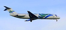 A Cebu Pacific DC-9 similar to the aircraft involved in the incident. | |
| Accident | |
|---|---|
| Date | 2 February 1998 |
| Summary | Controlled flight into terrain due to Pilot error and poor crew training |
| Site | Mount Sumagaya, Philippines 08°38′56.20″N 125°01′59.60″E / 8.6489444°N 125.0332222°ECoordinates: 08°38′56.20″N 125°01′59.60″E / 8.6489444°N 125.0332222°E |
| Aircraft | |
| Aircraft type | McDonnell Douglas DC-9-32 |
| Operator | Cebu Pacific |
| Registration | RP-C1507 |
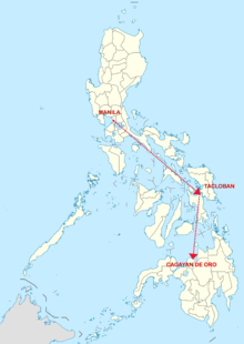
| Flight origin | Ninoy Aquino International Airport, Metro Manila, Philippines |
| Stopover | Daniel Z. Romualdez Airport, Tacloban, Philippines |
| Destination | Lumbia Airport, Cagayan de Oro, Philippines |
| Occupants | 104 |
| Passengers | 99 |
| Crew | 5 |
| Fatalities | 104 |
| Survivors | 0 |

Cebu Pacific Flight 387 was a domestic Cebu Pacific flight from Ninoy Aquino International Airport in Metro Manila to Lumbia Airport in Cagayan de Oro. On 2 February 1998, the 31-year-old McDonnell Douglas DC-9-32 crashed on the slopes of Mount Sumagaya in Gingoog. The incident resulted in the deaths of all 104 passengers and crew on board.[1][2]
Background[]
Aircraft[]
The aircraft involved in the accident was a McDonnell Douglas DC-9 (registration number RP-C1507) and was delivered to Air Canada on September 1967 before acquired by Cebu Pacific on March 1997.
Passengers and crew[]
The plane carried five crew members and 94 Filipino passengers, including five children. Five passengers were from Australia, Austria, Japan, Switzerland[2] and Canada. Additionally, a surgeon on a medical mission was from the United States.[3]
Accident[]
The plane left Manila at 01:00 GMT and was scheduled to arrive at 03:03 GMT in Cagayan de Oro. The plane made a stopover at Tacloban on 02:20 GMT, though sources differ about whether it was a scheduled or unscheduled stop.[3][4] According to one source, the flight made an unscheduled stop at Tacloban to deliver a needed airplane tire for another Cebu Pacific aircraft in Tacloban. The last contact was 15 minutes before the plane was due to land, with the airport's ATC. In that transmission, the pilot said he was 68 kilometres (42 mi; 37 nmi) from the airport and was starting to descend. There was no indication that the plane was in trouble. The plane crashed 45 kilometres (28 mi; 24 nmi) away from the airport.[3]
Cause[]
The cause of the crash is still a source of controversy in the Philippines. Colonel was the chief of the Philippine Air Force rescue team, which faced difficulties due to the deep ravines and dense vegetation on the slopes of the mountain. The pilots were flying visually, not instrumentally, when the plane vanished from radar.[2] While the skies were clear at the airport, the mountains may have been covered by fog. Chief of Staff General Clemente Mariano speculated that the plane "almost cleared the top of the mountain, but it may have suffered a down-draft, causing it to hit the mountain."[3] Jesus Dureza, the crisis manager during the rescue and retrieval operations, said he found out the Air Transportation Office maps used by the pilots listed the elevation of Mt. Sumagaya at 5,000 feet above sea level, while the mountain actually is 6,000 feet above sea level. This error might have misled the pilots to believe that they were clear of terrain, while in fact they were flying dangerously low. The ATO, on the other hand, pointed out in its official report deficiencies in the training of the pilots.[5]
References[]
- ^ "Air disasters timeline". BBC News. 2016-12-27.
- ^ a b c "Weather hampers Philippine air crash search". BBC News. 1998-02-04. Retrieved 2007-04-04.
- ^ a b c d "Passenger crash rescuers find no survivors". CNN. 1998-02-04. Retrieved 2007-04-04.[dead link]
- ^ "Passenger plane missing in the Philippines". BBC News. 1998-02-02. Retrieved 2007-04-04.
- ^ "15 years after flight 387 crashed questions remain unanswered". Mindanews. 2013-02-04. Retrieved 2013-09-01.
External links[]
- Airliner accidents and incidents caused by pilot error
- Aviation accidents and incidents in the Philippines
- Aviation accidents and incidents in 1998
- Accidents and incidents involving the McDonnell Douglas DC-9
- History of Misamis Oriental
- 1998 disasters in the Philippines
- Cebu Pacific
- February 1998 events in Asia
- Aviation accident investigations with disputed causes