Tacloban
Tacloban | |
|---|---|
Highly urbanized city | |
| City of Tacloban | |
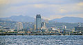
 Aerial view of Downtown Tacloban, Anibong, Naga-naga and Abucay districts | |
 Seal | |
| Nickname(s): | |
| Motto(s): City of Love, Beauty and Progress | |
 Map of Eastern Visayas with Tacloban highlighted | |
show OpenStreetMap | |
 Tacloban Location within the Philippines | |
| Coordinates: 11°14′N 125°00′E / 11.24°N 125°ECoordinates: 11°14′N 125°00′E / 11.24°N 125°E | |
| Country | Philippines |
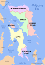
| Region | Eastern Visayas |
| Province | Leyte (geographically only) |
| District | 1st district |
| Established Provincial capital Chartered city[3] Highly urbanized city[4] | 1770 26 February 1830 12 June 1953 18 December 2008 |
| Barangay | 138 (see Barangays) |
| Government | |
| • Type | Sangguniang Panlungsod |
| • Mayor | Alfred S. Romualdez |
| • Vice Mayor | Jerry "Sambo" T. Yaokasin |
| • Representative | Ferdinand Martin G. Romualdez |
| • City Council | show
List |
| • Electorate | 139,423 voters (2019) |
| Area | |
| • Total | 201.72 km2 (77.88 sq mi) |
| Elevation | 40 m (130 ft) |
| Highest elevation | 574 m (1,883 ft) |
| Lowest elevation | 0 m (0 ft) |
| Population (2020 census) [7] | |
| • Total | 251,881 |
| • Density | 1,200/km2 (3,200/sq mi) |
| • Households | 49,541 |
| Demonym(s) | Taclobanon |
| Economy | |
| • Income class | 1st city income class |
| • Poverty incidence | 21.45% (2015)[8] |
| • Revenue | ₱1,155,729,018.56 (2018) |
| Service provider | |
| • Electricity | Leyte 2 Electric Cooperative (LEYECO 2) |
| Time zone | UTC+08:00 (PST) |
| ZIP code | 6500 |
| PSGC | |
| IDD : area code | +63 (0)53 |
| Climate type | tropical rainforest climate |
| Native languages | Waray Tagalog |
| Website | www |


Tacloban (/tækˈloʊbən/ tak-LOH-ban; Tagalog pronunciation: [tɐkˈloban]), officially the City of Tacloban (Waray: Syudad han Tacloban; Tagalog: Lungsod ng Tacloban), is a 1st class highly urbanized city in the Eastern Visayas region of the Philippines. The city is autonomous from the province of Leyte, although it serves as its provincial capital. According to the 2020 census, Tacloban has a population of 251,881, making it the most populous city in the Eastern Visayas. [7] The city is located 360 miles (580 km) southeast from Manila.
Tacloban City was briefly the capital of the Philippines under the Commonwealth Government, from 20 October 1944 to 27 February 1945. In an extensive survey conducted by the Asian Institute of Management Policy Center and released in July 2010, Tacloban City ranks as the fifth most competitive city in the Philippines, and second in the emerging cities category.[9] On 8 November 2013, the city was largely destroyed by Typhoon Haiyan, having previously suffered similar destruction and loss of life in 1897 and 1912.[10] On 17 January 2015, Pope Francis visited Tacloban during his Papal Visit to the Philippines and held a mass at Barangay San Jose, and later he led mass of 30,000 people in front of the airport.
History[]

Tacloban was first known as Kankabatok, an allusion to the first inhabitants – Kabatok. They established their dwellings in the vicinity of the present day Santo Niño Church. Others who came later were Gumoda, Haraging and Huraw who erected their own settlements in nearby sites. Huraw's domain is the hill where the city hall now sits. The combined settlements acquired the name Kankabatok, meaning Kabatok's property.
The constant threat of pirates due to its lack of a natural barrier hindered the development and progress of the settlement. And so the place never figured out in the early centuries of the Spanish colonization of Leyte. When the Jesuits (the first evangelizers of Leyte) left in 1768, the Augustinians took over and in 1770 they established the barrio with a chapel (visita) of Tacloban under the jurisdiction of Palo. The Augustinians who came from the Province of the Holy Name of Jesus based in Cebu were also responsible in introducing the devotion to the Santo Niño becoming therefore the heavenly patron of the settlement. With the Moro raids in check, the place became a hub for commercial activity and soon after the place was renamed Tacloban becoming an independent municipality and then capital of the province of Leyte. In 1843, the Augustinians ceded the administration of the parish to the Franciscans.
The change of the name came about in this manner: Kankabatok was a favorite haunt of fishermen. They would use a bamboo contraption called a "taklub" to catch crabs, shrimps or fish. When asked where they were going, the fishermen would answer, "(to) tarakluban", which meant the place where they used the device to catch these marine resources. Eventually, the name Tarakluban or Tacloban took prominence.
It is not known when Tacloban became a municipality because records supporting this fact were destroyed during a typhoon. It is commonly believed that Tacloban was officially proclaimed a municipality in 1770s. In 1768, Leyte and Samar were separated into two provinces, each constituting a politico-military province. Due to its strategic location, Tacloban became a vital trading point between the two provinces.
The capital of Leyte was transferred from one town to another with Tacloban as the last on 26 February 1830. The decision to make Tacloban the capital was based on the following reasons: 1) ideal location of the port and 2) well-sheltered and adequate facilities. On 20 June 1952, Tacloban was proclaimed a chartered city by virtue of Republic Act No. 760.[3]

The arrival of Colonel Arthur Murray in 1901 made him the first military governor of Leyte. His first official act was the opening of Tacloban port to world commerce. Before World War II, Tacloban was the commercial, education, social and cultural center of the Province of Leyte. Copra and abaca were exported in large quantities. The leading institutions were: Leyte Normal School, Leyte High School, Leyte Trade School, Holy Infant Academy and Tacloban Catholic Institute.
In November 1912, a typhoon swept through the central Philippines and "practically destroyed" Tacloban. In Tacloban and Capiz on the island of Panay, the death toll was 15,000, half the population of those cities at the time.[11]
On 25 May 1942, Japanese forces landed in Tacloban, signalling the beginning of their two-year occupation of Leyte. They fortified the city and improved its airfield. Since San Pedro Bay was ideal for larger vessels, the Japanese Imperial Naval Forces made Tacloban a port of call and entry. This time was considered the darkest in the history of Tacloban and the country due to the incidences of torture among civilians, including the elderly. In response, guerrilla groups operated in Leyte – the most notable of which was the group of Ruperto Kangleon.
Leyte was the first to be liberated by the combined Filipino and American troops. General Douglas MacArthur's assault troops landed in the Tacloban and Palo beaches (White Beach and Red Beach, respectively) and in the neighboring town of Dulag (Blue Beach) on 20 October 1944. These landings signaled the eventual victory of the Filipino and American forces and the fulfillment of MacArthur's famous promise: "I Shall Return."
Three days later, on 23 October, at a ceremony at the Capitol Building in Tacloban, MacArthur, accompanied by President Sergio Osmeña, made Tacloban the temporary seat of the Commonwealth Government and temporary capital of the Philippines until the complete liberation of the country.[12] The provincial government of Leyte and the municipal government of Tacloban were re-established.
Paulo Jaro was the Liberation mayor of Tacloban. The first mayor of this capital upon inauguration of the Philippine Republic was Epifanio Aguirre.
On 8 January 1960 MacArthur made his "sentimental" journey to Leyte. He was greeted with cheers by locals when he visited Tacloban.
The city was proclaimed as a highly urbanized city by President Gloria Macapagal Arroyo on 4 October 2008[13] and ratified by the people on 18 December 2008.[14] Tacloban was officially declared an HUC at 10:40PM of that day.
2013 Typhoon Haiyan[]

On 8 November 2013 (PST), Tacloban was hit by the full force of Typhoon Haiyan, causing massive destruction across the city. Dead bodies were scattered on the streets, trees were uprooted, and a 13 ft (4 m) storm surge largely destroyed the airport, though it functioned soon after as a makeshift command and evacuation center.[15] After taking a helicopter flight over the city, US Marine Brigadier General Paul Kennedy was quoted as saying, "I don't believe there is a single structure that is not destroyed or severely damaged in some way – every single building, every single house."[16] Widespread looting and violence is reported to have taken place[17] and local government virtually collapsed, as many city officials were victims.[18] President Aquino declared a state of emergency in Tacloban. The official final death toll stood at 6,201.[19]
2015 Papal visit[]
On 17 January 2015, Pope Francis, the leader of the Roman Catholic Church, arrived in Tacloban to celebrate Mass with the survivors of Haiyan (Yolanda).[20] The pope arrived at Daniel Z. Romualdez Airport on a flight operated by Philippine Airlines.
Geography[]
Tacloban is located on the northeastern tip of Leyte island, with its easternmost part facing Cancabato Bay. The bay is at the east mouth of San Juanico Strait. The Tacloban territory follows the length of the strait, along with Babatngon municipality north of the city. The strait divides the islands of Leyte and Samar.
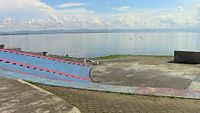
The left side of the Balyuan Park arena looking northeastward towards Cancabato Bay and the San Juanico Strait beyond, backgrounded by Samar island on the horizon.

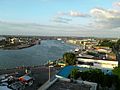
The eastern part of the city facing Cancabato Bay.
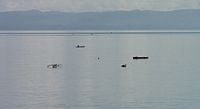
Fishing folks on outrigger canoes on Cancabato Bay, with the San Juanico Strait and Samar island in the background.


Barangays[]
The City of Tacloban is subdivided into 138 barangays, each having its own council.
Climate[]
Tacloban has a tropical rainforest climate (Köppen: Af) but due to the numerous cyclones present in the area, the climate is not equatorial. Tropical rainforest climates are tropical climates in which there is no dry season – all months have mean precipitation values of at least 60 millimetres (2.4 in). Tropical rainforest climates have no pronounced summer or winter; it is typically wet throughout the year and rainfall is both heavy and frequent. One day in an equatorial climate can be very similar to the next, while the change in temperature between day and night may be larger than the average change in temperature between "summer" and "winter".
The average high (daytime) temperature for the year in Tacloban is 31.1 °C (88.0 °F). The warmest month on average is May with an average daytime temperature of 32.3 °C (90.1 °F).[21] The coolest month on average is January and February, with an average (nighttime) temperature of 23.4 °C (74.1 °F).[21]
The highest recorded temperature was 38.0 °C (100.4 °F), recorded on April 6, 1924, and in August.[22] The lowest recorded temperature in Tacloban is 17.5 °C (63.5 °F) which was recorded in December.[22]
The average rainfall for the year is 2,659.3 millimetres (104.7 in), with the most rainfall on average in December with 386.0 millimetres (15.2 in) and the least on average in April with 115.2 millimetres (4.5 in).[21]
| hideClimate data for Tacloban City (1981–2010, extremes 1903–2012) | |||||||||||||
|---|---|---|---|---|---|---|---|---|---|---|---|---|---|
| Month | Jan | Feb | Mar | Apr | May | Jun | Jul | Aug | Sep | Oct | Nov | Dec | Year |
| Record high °C (°F) | 34.7 (94.5) |
34.8 (94.6) |
35.9 (96.6) |
38.0 (100.4) |
37.9 (100.2) |
36.5 (97.7) |
37.8 (100.0) |
38.0 (100.4) |
37.2 (99.0) |
36.0 (96.8) |
35.2 (95.4) |
35.0 (95.0) |
38.0 (100.4) |
| Average high °C (°F) | 29.2 (84.6) |
29.9 (85.8) |
30.7 (87.3) |
31.8 (89.2) |
32.3 (90.1) |
32.0 (89.6) |
31.6 (88.9) |
32.0 (89.6) |
31.8 (89.2) |
31.4 (88.5) |
30.7 (87.3) |
29.7 (85.5) |
31.1 (88.0) |
| Daily mean °C (°F) | 26.3 (79.3) |
26.6 (79.9) |
27.3 (81.1) |
28.3 (82.9) |
28.8 (83.8) |
28.6 (83.5) |
28.2 (82.8) |
28.4 (83.1) |
28.2 (82.8) |
28.0 (82.4) |
27.5 (81.5) |
26.8 (80.2) |
27.8 (82.0) |
| Average low °C (°F) | 23.4 (74.1) |
23.4 (74.1) |
23.8 (74.8) |
24.7 (76.5) |
25.3 (77.5) |
25.2 (77.4) |
24.8 (76.6) |
24.9 (76.8) |
24.7 (76.5) |
24.6 (76.3) |
24.4 (75.9) |
23.9 (75.0) |
24.4 (75.9) |
| Record low °C (°F) | 18.8 (65.8) |
17.6 (63.7) |
18.0 (64.4) |
20.2 (68.4) |
20.5 (68.9) |
20.9 (69.6) |
21.0 (69.8) |
20.6 (69.1) |
21.0 (69.8) |
19.8 (67.6) |
19.4 (66.9) |
17.5 (63.5) |
17.5 (63.5) |
| Average rainfall mm (inches) | 323.9 (12.75) |
238.4 (9.39) |
184.4 (7.26) |
115.2 (4.54) |
144.1 (5.67) |
184.6 (7.27) |
186.0 (7.32) |
160.9 (6.33) |
173.7 (6.84) |
243.9 (9.60) |
318.2 (12.53) |
386.0 (15.20) |
2,659.3 (104.70) |
| Average rainy days (≥ 0.1 mm) | 22 | 17 | 17 | 14 | 14 | 17 | 17 | 15 | 16 | 20 | 22 | 23 | 214 |
| Average relative humidity (%) | 87 | 85 | 83 | 82 | 83 | 84 | 84 | 83 | 84 | 86 | 86 | 88 | 85 |
| Source: PAGASA[21][22] | |||||||||||||
Demographics[]
| Year | Pop. | ±% p.a. |
|---|---|---|
| 1903 | 11,948 | — |
| 1918 | 15,787 | +1.87% |
| 1939 | 31,233 | +3.30% |
| 1948 | 45,421 | +4.25% |
| 1960 | 53,551 | +1.38% |
| 1970 | 76,531 | +3.63% |
| 1980 | 102,523 | +2.97% |
| 1990 | 136,891 | +2.93% |
| 1995 | 167,310 | +3.83% |
| 2000 | 178,639 | +1.41% |
| 2007 | 218,144 | +2.79% |
| 2010 | 221,174 | +0.50% |
| 2015 | 242,089 | +1.74% |
| 2020 | 251,881 | +0.78% |
| Source: Philippine Statistics Authority [23] [24] [25][26] | ||
According to the 2015 census, Tacloban has a population of 242,089 inhabitants.
Tacloban is predominantly a Waray-speaking city. The language is also officially called Lineyte-Samarnon ("Leyte-Samarnon") and spoken by more than 90% of the total city population. Waray-Waray, aside from being the native language of the city, is also the lingua franca used in the city among Filipinos of various ethnic groups.
Tacloban is culturally and linguistically diverse. A decade before the end of Spanish sovereignty, it was largely a typical colonial community: most of its residents were either pure Iberian families or the new generations of Spanish-Filipino blood. Today's population consists of a mix of Spanish and Chinese mestizos, foreign expatriates and native Leyteños.[citation needed]
Other Filipino ethnic groups who migrated in the city are Cebuano/Kana/Visayan speaking populace accounts 6.08% of the total population, 0.80% are Tagalog, 0.10% are Ilocano, 0.07% are Kapampangan while 2.95% come from other ethnic origins.
88.52% of the residents of Tacloban City are Roman Catholic; 6.12% are Muslims (most are Maranao migrants from Mindanao); 0.83% are of the indigenous Christian denomination, Iglesia ni Cristo; 0.94% are Evangelicals (born-again Christians); Baptists 0.80%; 0.49% Seventh Day Adventists. Others comprise 3.10%.
Economy[]
| Poverty Incidence of Tacloban | |
| Source: Philippine Statistics Authority[27][28][29][30][31][32] | |
This section does not cite any sources. (July 2018) |

Tacloban is the economic center of the entire Eastern Visayas, with an economy largely focused on agriculture, commerce, and tourism. Proximal to the city proper is the 237-hectare Eastern Visayas Agri-Industrial Growth Center (EVRGC), which was approved and accredited by the Philippine Economic Zone Authority by virtue of Presidential Proclamation No. 1210 on 23 April 1998. EVRGC serves as an eco-industrial hub with the Tacloban city government as its developer and operator. Several regional broadcasters are also based in the city including ABS-CBN TV-2 Tacloban and PRTV-12 Tacloban. The Daniel Z. Romualdez Airport also makes the city a key regional transportation hub.
Tacloban is one of the fastest growing cities in the Philippines, and has one of the lowest poverty incidence rates in the country (at roughly 9%, while the national poverty incidence stands at 30%). After its massive devastation on 8 November 2013, Tacloban was declared by its local government as a start-up city, which means everything had to start back from scratch. Currently the city is experiencing a rapid economic recovery.
Government[]

The executive power of the City Government is vested in the mayor. The Sangguniang Panlungsod or the city council has the legislative power to create city ordinances. It is a unicameral body composed of ten elected councilors and certain numbers of ex officio and sectoral representatives. It is presided by the vice mayor, the mayor and the elected city councilors who are elected-at-large every three years. The current city mayor is Alfred Romualdez.
The city government ceased to be under the supervision of the provincial government after it became a Highly Urbanized City in 2008. The city is now under the direct supervision of the national government.
Tacloban City is part of the 1st District of Leyte, alongside seven other municipalities: Alangalang, Babatngon, Palo, San Miguel, Santa Fe, Tanauan, and Tolosa. The district is currently represented by Congressman Martin Romualdez.
Official seal of the city of Tacloban[]

The official Seal of Tacloban is the symbol of the city's identity when it became a city under Republic Act No. 760 on 20 June 1952.
The city's emblem stands for the following physical attributes and character:[33]
- Left Portion - Symbolizes the province of Samar (Santa Rita), major supplier of agricultural and marine products to the city, stabilizing its volume of business and trade.
- Center - Stands for the beautiful and scenic San Juanico Strait
- The Galleon - Illustrates the ship of Ferdinand Magellan who landed in the island of Homonhon, Eastern Samar, the first Philippine island he sighted during the historic circumnavigation of the world
- Right Portion - Leyte side, where Tacloban City is located
Culture[]

The week-long celebrations peaks on 30 June,[34] the Grand fiesta of Tacloban celebrated with the traditional turn-over ceremonies of the "Teniente" made by the immediate past Hermano Mayor to the incoming Hermano Mayor. This is accompanied by the ritual of giving the medallion containing the names of all Hermanos Pasados and the Standartes. Fireworks and grand parades mark the occasion. Every house in the city prepares a feast and opens its doors to guests and well wishers.
- Subiran Regatta
- Subiran Regatta is a race of one-man native sailboats with outriggers locally called "subiran" along scenic and historic Leyte Gulf. The race is done without using a paddle but only skills and techniques to manoeuvre the sail. The Subiran Regatta is now on its 32nd year and counting. This contest is done annually on that weeklong celebration of the Tacloban City Fiesta. The race aims to preserve the art of sailing with the wind alone, and to showcase the mastery of this art by local boatmen.
- Balyuan
- Organized by the Department of Tourism and the city government, this activity which only started in 1975 is supposedly a re-enactment of a purported exchange of images between Barrio Buscada of Basey and Sitio Kankabatok, now Tacloban City. A local story which only saw print in the 20th century purports that in the old days, Sitio Kankabatok was a small barrio under the jurisdiction of Basey town in Samar. During the Feast of Santo Niño, the residents of Sitio Kankabatok would borrow the bigger image of the saint from the chapel of Barrio Buscada in Basey. Santo Niño is the revered patron saint of both Kankabatok and Barrio Buscada. The image is returned promptly after the festivities. When Kankabatok grew into a barrio of its own, the local Catholic authorities decided that the bigger Santo Niño image be retained in prospering village. However, because of its highly questionable anthropological and historical basis, the story can be best understood as simply etiological. It gives witness to the cultural, ethnographical and historical relationship between the people of south Samar and the eastern seaboard of Leyte. Likewise, stories of the image missing in Buscada and turning up in Kankabatok aided to this decision of honoring this relationship. The Basey Flotilla bearing the church and government leaders goes on a fluvial procession along San Pedro Bay. A budyong (shell) call announces the sight of the flotilla off Kankabatok Bay.
- Sangyaw Festival
- Sangyaw is an archaic Waray word which means to herald the news. The Sangyaw Festival was created by Imelda Marcos in the 1980s. The festival was revived in 2008 by her nephew, current city mayor Alfred Romualdez. The Sangyaw Festival invites contingents of different performing groups of various festivals in the country to compete in this side of the region. Cash prizes and trophies are at stake as the Sangyaw Festival grooms itself to be a big festival to watch out in the succeeding years.
Points of interest[]


Tacloban is a tourism hub and the primary gateway to Eastern Visayas. The region is world-renowned for its natural ecological beauty and diversity and for its historical significance in the Second World War.
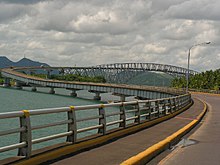
- San Juanico Bridge
- San Juanico Bridge, which is 2.16 kilometres (1.34 mi) long and connects the islands of Leyte and Samar across the San Juanico Strait, is the longest bridge in the Philippines. It was not significantly damaged due to Typhoon Haiyan and therefore was one of the critical gateways for the transportation of relief goods and the evacuation of refugees.[35]
- Santo Niño Shrine
- Home of the Marcos Family, it displays the fortune and previous properties of the Philippine dictator.[36] The shrine was severely damaged due to Typhoon Haiyan (2013), and repairs are nearly complete.[37]
- Price Mansion
- The Price Mansion is an example of American colonial homes built in the Philippines during the 1900s. It was the official residence and headquarters of General Douglas MacArthur during the Liberation of the Philippines period in 1944.[38] The building was the residence of Walter Scott Price and his wife Simeona Kalingag and their children.[39] It is now called as CAP Building located along Justice Romualdez Street.
- Santo Niño Church
- The Santo Niño Church is considered the most important religious site in the province. It houses the miraculous image of Santo Niño which is the patron saint of Tacloban. The church was severely damaged due to Typhoon Haiyan.[40] The church had to be rebuilt after Typhoon Haiyan. This was undertaken with the financial assistance of the Buddhist Tzu Chi Foundation.[41]
- Leyte Provincial Capitol
- The Leyte Provincial Capitol is a neoclassical building built in 1907. Located at the corner of Sen. Enage Street and Magsaysay Boulevard, the "Kapitolyo" is the seat of the provincial government of Leyte. It was also the seat of the Commonwealth Government of the Philippines when President Sergio Osmeña landed here in 1944 with the WWII Liberation Forces. The Capitol was damaged in 2013 by Typhoon Haiyan.
- Tacloban Metropolitan Arena
- Popularly known as the "Astrodome," the Tacloban City Convention Center is a 5,000-seat indoor arena which is now the perfect location for basketball tourneys and other sporting activities, concerts and other big gatherings like the "Search for Ms. Tacloban". It also houses many bars and businesses. The arena was severely damaged by Typhoon Haiyan but still served as an evacuation center after the typhoon devastation.
- People's Center Library
- The library houses a collection of books of different cultures from around the globe – USA, Europe and other countries – including French, Spanish and English literature as well as a compilation of law books. The People's Center Library is used by local students as well as researchers. It is like a Greek building that houses the collection of books such as Imelda Marcos's. It is the alleged oldest library in Tacloban and the whole Eastern Visayas (Region VIII).[42]
- Balyuan Park
- Balyuan Park is located at the grounds of Magsaysay Boulevard. The park a famous spot to watch the sun rise from across the bay behind the Cataisan Peninsula where the Daniel Z. Romualdez Airport is located.
- Madonna of Japan
- The Madonna of Japan serves a symbol of friendship between the Japanese and Filipinos. It is located at the Kanhuraw Hill near City Hall, facing Kankabato Bay. During the Second World War, the place became a campground for Japanese soldiers.
Transportation[]

Tacloban is served by air, multicabs, taxis, jeepneys, buses, tricycles and pedicabs. Daniel Z. Romualdez Airport has had plans (for many years) to upgrade to an international airport. At present, the airport is served by four airlines that offer domestic flights to and from Manila, Cebu, Davao, and Clark. The New Transport Terminal of Tacloban City or New Bus Terminal located in Abucay district serves as the land transportation hub to and from various points in the region.
Healthcare[]

As the regional center of Eastern Visayas, Tacloban offers a range of healthcare services. There are a number of hospitals and other medical institutions serving the city's population.
- Public hospitals
- Eastern Visayas Medical Center (EVMC)
- Tacloban City Hospital
- Private hospitals
- Divine Word Hospital (owned by the Benedictine Sisters)
- Our Mother of Mercy Hospital (owned by the Religious Sisters of Mercy)
- Remedios Trinidad Romualdez Hospital (owned by the RTR Medical Foundation)
- Tacloban Doctors Medical Center (owned by a group of locally prominent doctors)
- ACE Medical Center Tacloban (just past the nearby shopping mall on the way to Palo)
Education[]
Tacloban has a variety of educational institutions both public and private.
Notable institutions include:
- University of the Philippines Visayas Tacloban College
- Leyte Normal University
- Eastern Visayas State University
- Holy Infant College
- Holy Spirit Foundation College, Inc.
- Holy Virgin of Salvacion Foundation College, Inc.
- ABE International Business College Tacloban
- ACLC College of Tacloban
- AMA College Tacloban[43] (currently located in nearby Palo, Leyte)
- Asia Pacific Career College
- Asian Development Foundation College
- Colegio De La Salle Fondation de Tacloban, Inc.
- Dr. Vicente Orestes Romualdez Educational Foundation (College of Law)
- JE Mondejar Computer College
- Leyte Colleges
- National Maritime Polytechnic
- Remedios Trinidad Romualdez Medical Foundation
- Sacred Heart College of Tacloban
- St. Scholastica's College, Tacloban (currently located in nearby Palo, Leyte)
- St. Benedict College of Tacloban, Inc.
- Liceo del Verbo Divino (formerly "Divine Word University of Tacloban")
- St. Therese Educational Center of Leyte (STECL)
- St. Therese Christian Development Center Foundation, Inc. (STCDCFI)
- St. Therese Educational Foundation of Tacloban, Inc. (STEFTI)
- Saint Arnold Janssen College of Tacloban, Inc.
Sister cities[]
International[]
 Fukuyama, Hiroshima, Japan[44]
Notable people[]
- Merlie Alunan - poet; instructor
- Gina Apostol - writer
- Norberto Castillo - 91st Rector Magnificus of the University of Santo Tomas
- Dennis Daa - professional basketball player
- Dan Palami - businessman; manager of Philippine Azkals
- Karla Estrada - actress and singer
- Jose Mari Gonzales - actor; father of Cristina Gonzales-Romualdez
- Ruby Ibarra - Filipina-American rapper
- Iluminado Lucente - the "grand old man of Waray letters"; poet, playwright, and mayor of Tacloban[45]
- Imelda Romualdez-Marcos - Former First Lady and former Representative for Leyte's 1st District
- Rudy Robles - actor
- Cristina Romualdez - former actress and former mayor of Tacloban City
- Lou Salvador - basketball player
- Kim Chiu - Pinoy Big Brother Teen Edition Winner; television and movie star
- Ted Failon - news anchor; TV and radio personality
- Carlo Francisco Manatad - filmmarker and editor
- Benjamin Romualdez - former governor of Leyte; former ambassador to the US, China and Saudi Arabia
- Dino Daa - professional basketball player
- Bullet Dumas - indie and contemporary folk singer-songwriter
References[]
- ^ "National transformation in Eastern Visayas". The Manila Times. 17 October 2014. Archived from the original on 24 March 2017. Retrieved 21 April 2019.
But the most striking work of physical transformation today is to be seen in Tacloban City, which remains the gateway to Eastern Visayas.
- ^ Reyes, Ronald O. (20 April 2018). "'Tacloban City: Home of the happiest people in the world' goes viral". SunStar. Archived from the original on 21 April 2019. Retrieved 21 April 2019.
- ^ Jump up to: a b "Proclamation No. 394, s. 1953". 6 June 1953. Retrieved 21 February 2018.
Pursuant to the authority conferred upon me by section 89 of Republic Act No. 760, creating the City of Tacloban, I, Elpidio Quirino, President of the Philippines, do hereby fix June 12, 1953, for the organization of the Government of the City of Tacloban.
- ^ COMELEC Minute Resolution No. 09-0036
- ^ City of Tacloban | (DILG)
- ^ "2015 Census of Population, Report No. 3 – Population, Land Area, and Population Density" (PDF). Philippine Statistics Authority. Quezon City, Philippines. August 2016. ISSN 0117-1453. Archived (PDF) from the original on 25 May 2021. Retrieved 16 July 2021.
- ^ Jump up to: a b Census of Population (2020). "Region VIII (Eastern Visayas)". Total Population by Province, City, Municipality and Barangay. PSA. Retrieved 8 July 2021.
- ^ https://psa.gov.ph/sites/default/files/City%20and%20Municipal-level%20Small%20Area%20Poverty%20Estimates_%202009%2C%202012%20and%202015_0.xlsx; publication date: 10 July 2019; publisher: Philippine Statistics Authority.
- ^ "Cities and Enterprises, Competitiveness and Growth: Philippine Cities Competitiveness Ranking Project 2009". Asian Institute of Management Policy Center. 2010. Archived from the original on 14 January 2014. Retrieved 13 April 2013.
- ^ Ocampo, Ambeth R. (19 November 2013). "Tacloban, not once but thrice". Philippine Daily Inquirer. Archived from the original on 22 November 2013.
- ^ "15,000 Die in Philippine Storm". Washington Herald. 30 November 1912. Retrieved 19 November 2013.
- ^ "Proclamation of General Douglas MacArthur to the People of the Philippines, October 23, 1944". Official Gazette of the Republic of the Philippines. 23 October 1944. Retrieved 21 February 2018.
- ^ Proclamation No. 1637 dated 4 October 2008
- ^ "Tacloban is 1st highly urbanized city". Cebu Daily News. Philippine Daily Inquirer. 20 December 2008. Archived from the original on 22 May 2011. Retrieved 2 December 2010.
- ^ "Typhoon Haiyan: thousands dead as devastation hampers aid efforts". 11 November 2013. Retrieved 11 November 2013.
- ^ "Philippines declares state of calamity President declares emergency measures as aid trickles in for millions of people left destitute by the Haiyan superstorm". aljazeera.com. 11 November 2013. Retrieved 11 November 2013.
- ^ "Philippine Red Cross says typhoon relief efforts being hampered by looters". foxnews.com. 10 November 2013. Retrieved 12 November 2013.
- ^ "Tons of aid arriving in Philippines, but debris, logistics hampering relief efforts". foxnews.com. 12 November 2013. Retrieved 12 November 2013.
- ^ SitRep No. 92 : Effects of Typhoon "YOLANDA" (HAIYAN), Tab A : CASUALTIES (PDF) (Report). National Disaster Risk Reduction and Management Council of the Philippines. 14 January 2014. Archived from the original (PDF) on 17 January 2014.
- ^ "Pope Francis cuts short visit to typhoon-hit Tacloban". BBC News. Retrieved 26 September 2018.
- ^ Jump up to: a b c d "Tacloban City, Leyte Climatological Normal Values". Philippine Atmospheric, Geophysical and Astronomical Services Administration. Archived from the original on 18 October 2018. Retrieved 18 October 2018.
- ^ Jump up to: a b c "Tacloban City, Leyte Climatological Extremes". Philippine Atmospheric, Geophysical and Astronomical Services Administration. Archived from the original on 18 October 2018. Retrieved 18 October 2018.
- ^ Census of Population (2015). "Region VIII (Eastern Visayas)". Total Population by Province, City, Municipality and Barangay. PSA. Retrieved 20 June 2016.
- ^ Census of Population and Housing (2010). "Region VIII (Eastern Visayas)". Total Population by Province, City, Municipality and Barangay. NSO. Retrieved 29 June 2016.
- ^ Censuses of Population (1903–2007). "Region VIII (Eastern Visayas)". Table 1. Population Enumerated in Various Censuses by Province/Highly Urbanized City: 1903 to 2007. NSO.
- ^ "Province of Leyte". Municipality Population Data. Local Water Utilities Administration Research Division. Retrieved 17 December 2016.
- ^ "Poverty incidence (PI):". Philippine Statistics Authority. Retrieved 28 December 2020.
- ^ https://psa.gov.ph/sites/default/files/NSCB_LocalPovertyPhilippines_0.pdf; publication date: 29 November 2005; publisher: Philippine Statistics Authority.
- ^ https://psa.gov.ph/sites/default/files/2003%20SAE%20of%20poverty%20%28Full%20Report%29_1.pdf; publication date: 23 March 2009; publisher: Philippine Statistics Authority.
- ^ https://psa.gov.ph/sites/default/files/2006%20and%202009%20City%20and%20Municipal%20Level%20Poverty%20Estimates_0_1.pdf; publication date: 3 August 2012; publisher: Philippine Statistics Authority.
- ^ https://psa.gov.ph/sites/default/files/2012%20Municipal%20and%20City%20Level%20Poverty%20Estima7tes%20Publication%20%281%29.pdf; publication date: 31 May 2016; publisher: Philippine Statistics Authority.
- ^ https://psa.gov.ph/sites/default/files/City%20and%20Municipal-level%20Small%20Area%20Poverty%20Estimates_%202009%2C%202012%20and%202015_0.xlsx; publication date: 10 July 2019; publisher: Philippine Statistics Authority.
- ^ "City Seal". Official website of the City Government of Tacloban. Retrieved 30 March 2013.
- ^ "REPUBLIC ACT NO. 7676 - AN ACT DECLARING JUNE THIRTY OF EVERY YEAR A SPECIAL NONWORKING PUBLIC HOLIDAY IN TACLOBAN CITY, PROVINCE OF LEYTE, TO BE KNOWN AS "TACLOBAN DAY"". 10 January 1994. Retrieved 20 March 2013.
- ^ Typhoon Haiyan - Live Blogs - Al Jazeera English
- ^ "Santo Niño Shrine and Heritage Museum: A Collection of Filipinos' Grandiose Past". ChoosePhilippines. Retrieved 20 September 2018.
- ^ "Imelda Marcos's Tacloban palace to complete rehabilitation soon". BusinessWorld. Retrieved 3 October 2018.
- ^ "The Price Mansion". tourisminthephilippines. Retrieved 21 September 2018.
- ^ "Price Mansion's History". EV Learners. 2 June 2017. Retrieved 21 September 2018.
- ^ "First post-Yolanda mass held at Santo Niño parish". ABS-CBN News. Retrieved 2 October 2018.
- ^ "SantoNiño Church undergoes repair". CBPC News. Retrieved 2 October 2018.
- ^ "People's Center and Library: The House of Books in Tacloban".
- ^ "AMA Computer University". Amaes.edu.ph. Archived from the original on 14 February 2012. Retrieved 17 January 2012.
- ^ "List of Sister City Affiliations with Japan (by country): Philippines". Singapore: Japan Council of Local Authorities for International Relations (CLAIR, Singapore). 29 February 2012. Retrieved 7 March 2015.
- ^ Sugbo, Victor, ed. (1995). Tinipigan: An Anthology of Waray Literature. Manila, Philippines: National Commission for Culture and the Arts. p. 271. OCLC 645852700. Retrieved 27 September 2019.
External links[]
| Wikimedia Commons has media related to Tacloban. |
| Wikivoyage has a travel guide for Tacloban. |
- Official website
- Philippine Standard Geographic Code
- Typhoon Haiyan appears to be the deadliest natural disaster on record
- Official Website of the Provincial Government of Leyte
 Geographic data related to Tacloban at OpenStreetMap
- . New International Encyclopedia. 1905.
| show Places adjacent to Tacloban |
|---|
| show Articles Related to Tacloban |
|---|


| show Authority control |
|---|
- Tacloban
- 1770 establishments in the Philippines
- Cities in Leyte (province)
- Highly urbanized cities in the Philippines
- Populated places established in 1770
- Provincial capitals of the Philippines