Ceto, Lombardy
Ceto
Hét | |
|---|---|
| Comune di Ceto | |
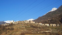 Ceto's panorama | |
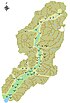
 Comune of Ceto in Val Camonica | |
Location of Ceto  | |
 Ceto Location of Ceto in Italy | |
| Coordinates: 46°0′12″N 10°21′10″E / 46.00333°N 10.35278°ECoordinates: 46°0′12″N 10°21′10″E / 46.00333°N 10.35278°E | |
| Country | Italy |
| Region | Lombardy |
| Province | Province of Brescia (BS) |
| Frazioni | , Nadro |
| Government | |
| • Mayor | Marina Lanzetti |
| Area | |
| • Total | 32.3 km2 (12.5 sq mi) |
| Elevation | 453 m (1,486 ft) |
| Population (30 May 2017)[2] | |
| • Total | 1,900 |
| • Density | 59/km2 (150/sq mi) |
| Demonym(s) | Cetesi |
| Time zone | UTC+1 (CET) |
| • Summer (DST) | UTC+2 (CEST) |
| Postal code | 25040 |
| Dialing code | 0364 |
| Patron saint | |
| Saint day | 30 November |
| Website | Official website |


the Tow Hall
Ceto (Camunian: Hét) is an Italian comune in Val Camonica, province of Brescia, in Lombardy.
The village of Ceto is bounded by other communes of Braone, Breno, Capo di Ponte, Cerveno, Cevo, Cimbergo, Daone (TN), Ono San Pietro.
History[]
In February 1798 the town of Nadro was united to that of Ceto, and assumed the name of "comune of Ceto and Nadro. "
Between 1816 and 1859 the town was called "Ceto with Nadro", while from 1859 to 1927 only "Ceto". In that year he was joined Cerveno, which was linked with the name "Ceto Cerveno" until 1947.
Main sights[]
- Church of St. Andrew the Apostle. Rebuilt on a previous building in 1700 from a design by Anthonio Spiazzi.
- Church of Saints Faustino and Jovita.
References[]
- ^ "Superficie di Comuni Province e Regioni italiane al 9 ottobre 2011". Italian National Institute of Statistics. Retrieved 16 March 2019.
- ^ ISTAT Archived March 3, 2016, at the Wayback Machine
External links[]
| Wikimedia Commons has media related to Ceto. |
- (in Italian) Historical photos - Intercam
- (in Italian) Historical photos - Lombardia Beni Culturali
This article on a location in the Province of Brescia is a stub. You can help Wikipedia by . |
Categories:
- Cities and towns in Lombardy
- Municipalities of the Province of Brescia
- Province of Brescia geography stubs