Champdepraz
Champdepraz | |
|---|---|
| Comune di Champdepraz Commune de Champdepraz | |
 | |
 Coat of arms | |
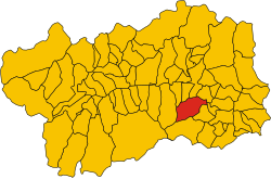 Location of the comune within the Aosta Valley | |
Location of Champdepraz  | |
 Champdepraz Location of Champdepraz in Italy | |
| Coordinates: 45°41′N 7°39′E / 45.683°N 7.650°E | |
| Country | Italy |
| Region | Aosta Valley |
| Frazioni | Barbustel, Blanchet, Bodeun, Capiron, Chef-lieu, Chantonet, Covarey, Crestaz, Cugnon, Dialley, Fabrique, Fussy, Gettaz-des-Allemands, Hérin, La Veulla, Le Sale, Losson, Viéring |
| Government | |
| • Mayor | Angelo Lanièce |
| Area | |
| • Total | 48 km2 (19 sq mi) |
| Elevation | 523 m (1,716 ft) |
| Population (January 2017)[3] | |
| • Total | 714[1] |
| Demonym(s) | Champdeprasiens |
| Time zone | UTC+1 (CET) |
| • Summer (DST) | UTC+2 (CEST) |
| Postal code | 11020 |
| Dialing code | 0125 |
| Patron saint | Saint Francis of Sales |
| Saint day | 24 January |


Champdepraz (Arpitan: Tsandeprà, lit. 'field of meadows'); is a town and comune in the Aosta Valley region of northwestern Italy.

Village church in La Veulla, Champdepraz.
The town is situated in the , a lateral valley of the Aosta Valley. The hydroelectric power station of Champdepraz is using the power of the water from to generate electricity. The headquarter of the Parco naturale del Mont Avic, founded in 1989, is also located in this town.
See also[]
- Mont Avic
- Mont Glacier
- Gran Lago
References[]
- ^ Bilancio demografico anno 2017 (dati provvisori) Comune: Champdepraz, demo.istat.it
- ^ "Superficie di Comuni Province e Regioni italiane al 9 ottobre 2011". Italian National Institute of Statistics. Retrieved 16 March 2019.
- ^ "Popolazione Residente al 1° Gennaio 2018". Italian National Institute of Statistics. Retrieved 16 March 2019.
External links[]
- Champdepraz, lovevda.it
- Torrente Chalamy (Champdepraz), guidegranparadiso.com

This Aosta Valley location article is a stub. You can help Wikipedia by . |
Categories:
- Cities and towns in Aosta Valley
- Municipalities of Aosta Valley
- Aosta Valley geography stubs