Valtournenche
This article needs additional citations for verification. (December 2009) |
Valtournenche
Vótornéntse | |
|---|---|
| Comune di Valtournenche Commune de Valtournenche | |
 | |
 Coat of arms | |
show Location of Valtournenche | |
 Valtournenche Location of Valtournenche in Italy | |
| Coordinates: 45°53′N 07°37′E / 45.883°N 7.617°ECoordinates: 45°53′N 07°37′E / 45.883°N 7.617°E | |
| Country | Italy |
| Region | Aosta Valley |
| Province | none |
| Frazioni | Barmasse, Bioley, Brengaz, Breuil-Cervinia, Busserailles, Chaloz, Châtelard, Champ l'éve, Cheneil, Cheperon, Tsignanaz (Cignana), Clou, Cré, Cré-du-Pont, Crépin, Crétaz, Duerche, Euillaz, Fontaine, La Muranche, La Vénaz, Layet, Laviel, Le Lou (Loz), Losanche, Maën, Maisonnasse, Montaz, Moulin, Mont-Mené, Mont-Perron, Pâquier (chef-lieu), Pecou, Les Perrères, Pessey, Promindoz, Saix, Servaz, Singlin, Tourtourouse, Ussin, Valmartin |
| Area | |
| • Total | 115 km2 (44 sq mi) |
| Elevation | 1,528 m (5,013 ft) |
| Population (December 31, 2004)[2] | |
| • Total | 2,163 |
| • Density | 19/km2 (49/sq mi) |
| Demonym(s) | Valtournains |
| Time zone | UTC+1 (CET) |
| • Summer (DST) | UTC+2 (CEST) |
| Postal code | 11028 |
| Dialing code | 0166 |
| Website | http://www.comune.valtournenche.ao.it |


Valtournenche (local Valdôtain: Vótornéntse) is a town and comune in the Aosta Valley region of north-western Italy, 1500m above the sea level. It is named after and covers most of the Valtournenche, a valley on the left side of the Dora Baltea, from Châtillon to the Matterhorn. Valtournenche is close to Cervinia and in winter the two towns are connected also with the ski slopes. In fact, they are part of the same ski resort with also Zermatt, Switzerland.[3]
History[]
This section is empty. You can help by . (March 2020) |
Notable people[]
- Jean-Antoine Carrel (1829–1890), mountain climber
- (1829–1890), mountain climber
- (1800–1870), canon, mountain climber and botanist
- Luigi Carrel (1901–1983), mountain climber
- Piero Maquignaz, skier and mountain climber
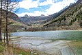
The Maën lake

Maën lake seen from Pâquier


References[]
- ^ "Superficie di Comuni Province e Regioni italiane al 9 ottobre 2011". Istat. Retrieved 16 March 2019.
- ^ "Popolazione Residente al 1° Gennaio 2018". Istat. Retrieved 16 March 2019.
- ^ "Valtournenche". Cervinia Ski Paradise. Cervinia. Retrieved 11 October 2018.
| show Comuni of Aosta Valley |
|---|

This Aosta Valley location article is a stub. You can help Wikipedia by . |
Categories:
- Cities and towns in Aosta Valley
- Municipalities of Aosta Valley
- Aosta Valley geography stubs