Chanchaga
Chanchaga | |
|---|---|
LGA | |
 Chanchaga Location in Nigeria | |
| Coordinates: 9°36′50″N 6°33′25″E / 9.61389°N 6.55694°ECoordinates: 9°36′50″N 6°33′25″E / 9.61389°N 6.55694°E | |
| Country | |
| State | Niger State |
| Area | |
| • Total | 72 km2 (28 sq mi) |
| Population (2006 census) | |
| • Total | 201,429 |
| Time zone | UTC+1 (WAT) |
| 3-digit postal code prefix | 920 |
| ISO 3166 code | NG.NI.CH |

Chanchaga is a Local Government Area in Niger State, Nigeria. Its headquarters is in the state capital of Minna which occupies much of the Local Government Area.
It has an area of 72 km2 and a population of 201,429 at the 2006 census.
The postal code of the area is 920.[1]
History[]
There are a lot of institute for learning in chanchaga local government, under chanchaga we also have paikoro local government where we have our international yam market.
References[]
- ^ "Post Offices- with map of LGA". NIPOST. Archived from the original on 2009-10-07. Retrieved 2009-10-20.
State capital: Minna | ||
| Local Government Areas | 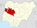 | |
This Niger State, Nigeria location article is a stub. You can help Wikipedia by . |
Categories:
- Local Government Areas in Niger State
- North Central Nigeria geography stubs