Chapel-le-Dale
| Chapel-le-Dale | |
|---|---|
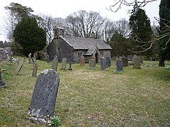 St Leonards Church | |
 Chapel-le-Dale Location within North Yorkshire | |
| OS grid reference | SD739769 |
| Shire county | |
| Region | |
| Country | England |
| Sovereign state | United Kingdom |
| Post town | Carnforth |
| Postcode district | LA6 |
| Police | North Yorkshire |
| Fire | North Yorkshire |
| Ambulance | Yorkshire |
| UK Parliament |
|

Chapel-le-Dale is a hamlet in the civil parish of Ingleton, North Yorkshire, England. It is in the Yorkshire Dales and was previously in the West Riding of Yorkshire.
History[]
The hamlet is situated on the B6255 road between Ingleton and Ribblehead near to the Ribblehead Viaduct. The name derives from Old French and literally means Chapel in the valley.[1] It was first recorded as Chappell ith Dale in 1677.[2] Historically, the hamlet, and its parish, were both in the Wapentake of Ewcross and up until 1974, they were in the West Riding of Yorkshire.[3][4]
The hamlet is in close proximity to Ingleborough and Whernside and there are several potholes in the vicinity,[5] the best known being Great Douk Cave. There is a pub in the village, The Old Hill Inn, which is used as a starting and ending point for various walks on Whernside or Ingleborough.[6] The source of the River Doe is nearby.

There is a church in the hamlet (The Church of St Leonard) which is now a grade II listed building. It was used as a burial plot for the navvies, and their family members, who died whilst constructing the nearby Ribblehead Viaduct between 1869 and 1876. In all, over 200 people died during the construction from accidents and outbreaks of smallpox. A plaque was erected in the church to their memory.[7][8][9]
References[]
- ^ Chrystal, Paul (2017). The Place Names of Yorkshire. Catrine: Stenlake. p. 25. ISBN 9781840337532.
- ^ "Archaeological survey in Chapel-le-Dale, North Yorkshire" (PDF). outofoblivion.org.uk. The Brigantia Archaeological Practice. June 2001. p. 10. Retrieved 2 January 2018.
- ^ "Genuki: In 1822, the following places were in the Parish of Low Bentham:, Yorkshire (West Riding)". www.genuki.org.uk. Retrieved 2 January 2018.
- ^ "History of Chapel le Dale, in Craven and West Riding | Map and description". www.visionofbritain.org.uk. Retrieved 2 January 2018.
- ^ Buckley, Norman (1995). Yorkshire Dales walking : on the level (3 ed.). Wilmslow: Sigma Leisure. p. 65. ISBN 1-85058-439-7.
- ^ Upton, Hannah (20 February 2013). "REVIEW: Old Hill Inn, Chapel-le-Dale". The Westmorland Gazette. Retrieved 2 January 2018.
- ^ Moore, Lindsey (20 November 2014). "Life and death on the Settle-Carlisle". Craven Herald. Retrieved 2 January 2018.
- ^ Historic England. "Church of St Leonard (Grade II) (1213046)". National Heritage List for England. Retrieved 2 January 2018.
- ^ "Plaque to be unveiled in memory of railway workers". Craven Herald. 4 August 2000. Retrieved 2 January 2018.
External links[]
| Wikimedia Commons has media related to Chapel-le-Dale. |
| hide Authority control | |
|---|---|
| General | |
| National libraries | |
- Hamlets in North Yorkshire