West Riding of Yorkshire
| County of York, West Riding | |
|---|---|
 Flag of West Riding (2013)[1] | |
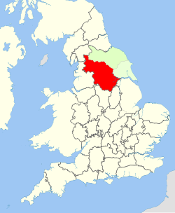 1888–1974: County of York in England: West Riding (red), North Riding (light green), and East Riding (very pale green) | |
| Area | |
| • 1911 | 1,685,409 acres (6,820.61 km2) |
| • 1961 | 1,621,068 acres (6,560.23 km2) |
| Population | |
| • 1901 | 1,538,572 |
| History | |
| • Created | Historic riding – AD 889 Administrative county – 1889 |
| • Abolished | Historic riding – not abolished Administrative county – 1974 |
| • Succeeded by | West Yorkshire South Yorkshire North Yorkshire Lancashire Cumbria Greater Manchester Humberside |
| Status | Ancient riding, then administrative county |
| Chapman code | WRY |
| Government | |
| • HQ | Wakefield |
| • Motto | Audi consilium (Heed counsel)[2] |
 Coat of arms of West Riding County Council | |
The West Riding of Yorkshire is one of three historic subdivisions of Yorkshire, England. From 1889 to 1974 the administrative county, County of York, West Riding (abbreviated: County of York (WR)) (the area under the control of West Riding County Council), was based closely on the historic boundaries. The lieutenancy at that time included the City of York and as such was named West Riding of the County of York and the County of the City of York.[3]
Its boundaries roughly correspond to the present ceremonial counties of West Yorkshire, South Yorkshire and the Craven, Harrogate and Selby districts of North Yorkshire, along with smaller parts in Lancashire (for example, the parishes of Barnoldswick, Bracewell, Brogden and Salterforth became part of the Pendle district of Lancashire and the parishes of Great Mitton, Newsholme and Bowland Forest Low became part of the Ribble Valley district also in Lancashire), Cumbria, Greater Manchester and, since 1996, the unitary East Riding of Yorkshire.
Geography[]
The West Riding encompasses 1,771,562 acres (7,169 km2) from Sheffield in the south to Sedbergh in the north and from Dunsop Bridge in the west to Adlingfleet in the east.
The southern industrial district, considered in the broadest application of the term, extended northward from Sheffield to Skipton and eastward from Sheffield to Doncaster, covering less than one-half of the riding. Within this district were Barnsley, Batley, Bradford, Brighouse, Dewsbury, Doncaster, Halifax, Huddersfield, Keighley, Leeds, Morley, Ossett, Pontefract, Pudsey, Rotherham, Sheffield, Todmorden (partly in Lancashire until 1888, when fully incorporated into Yorkshire) and Wakefield. Major centres elsewhere in the riding included Harrogate and Ripon.
Within the industrial region, other urban districts included Bingley, Bolton on Dearne, Castleford, Cleckheaton, Elland, Featherstone, Handsworth, Hoyland Nether, Liversedge, Mexborough, Mirfield, Normanton, Rawmarsh, Rothwell, Saddleworth, Shipley, Skipton, Sowerby Bridge, Stanley, Swinton, Thornhill, Wath-upon-Dearne, Wombwell and Worsborough. Outside the industrial region were Goole, Ilkley, Knaresborough and Selby. The West Riding also contained a large rural area to the north including part of the Yorkshire Dales National Park (the remainder of the park being in the North Riding).
History[]
The subdivision of Yorkshire into three ridings or "thirds" (Old Norse: Þriðungr) is of Scandinavian origin. The West Riding was first recorded (in the form West Treding) in the Domesday Book of 1086.[4]
Unlike most English counties, Yorkshire, being so large, was divided first into the three ridings (East, North and West) and, later, the city of York (which lay within the city walls and was not part of any riding). Each riding was then divided into wapentakes, a division comparable to the hundreds of Southern England and the wards of England's four northernmost historic counties.
Wapentakes[]
Within the West Riding of Yorkshire there were ten wapentakes in total, four of which were split into two divisions, those were— Claro (Upper and Lower), Skyrack (Upper and Lower), Strafforth and Tickhill (Upper and Lower) and Staincliffe (East and West). The wapentake of Agbrigg and Morley was created with two divisions but was later split into two wapentakes. A wapentake known as the Ainsty to the west of York, was until the 15th century a wapentake of the West Riding, but since then has come under the jurisdiction of the City of York
|
 |
Administrative county[]
The administrative county was formed in 1889 by the Local Government Act 1888, and covered the historic West Riding except for the larger urban areas, which were county boroughs with the powers of both a municipal borough and a county council. Initially there were five in number: Bradford, Leeds, Huddersfield, Halifax, and Sheffield. The City of York (also a county borough) was included in the county for census and lieutenancy purposes. The number of county boroughs increased over the years; Rotherham gained this status in 1902, Barnsley and Dewsbury in 1913, Wakefield in 1915 and Doncaster in 1927. The boundaries of existing county boroughs were also widened.
Beginning in 1898, the West Riding County Council was based at the County Hall in Wakefield, which was inherited by the West Yorkshire County Council in 1974.[5]
The Local Government Act 1888 included the entirety of Todmorden with the West Riding administrative county, and also in its lieutenancy area ("county"). Other boundary changes in the county included the expansion of the county borough of Sheffield southward in areas historically in Derbyshire such as Dore.

Fingerposts erected in the West Riding until the mid-1960s had a distinctive style. At the top of the post was a roundel in the form of a hollow circle with a horizontal line across the middle, displaying "Yorks W.R.", the name of the fingerpost's location, and a grid reference. Other counties, apart from Dorset,[6] did not display a grid reference and did not have a horizontal bar through the roundel. From 1964, many fingerposts were replaced by ones in the modern style, but some of the old style still survive within the West Riding boundaries.
By 1971 1,924,853 people (or 50.85% of the West Riding's population) lived in the administrative county, against 1,860,435 (or 49.15%) in the ten county boroughs.
Current usage[]

The term West Riding is still used in the names of the following clubs, and organisations:
- 33rd Foot, First Yorkshire West Riding Regiment , a re-enactment group based in Halifax who depict this Regiment during the Napoleonic Wars
- 49 (West Riding) Signal Squadron (Volunteers), a squadron of 34 (Northern) Signal Regiment (Volunteers) based at Carlton Barracks in Leeds
- 51st (2nd Yorkshire, West Riding) Light Infantry , a re-enactment group based in the West Midlands who depict this Regiment during the Napoleonic Wars
- 106 (West Riding) Field Squadron, a squadron of 72 Engineer Regiment (Volunteers) based in Greenhill, Sheffield and Manningham Lane, Bradford
- 269 (West Riding) Battery Royal Artillery, a Surveillance and Target Acquisition battery of 101 (Northumbrian) Regiment Royal Artillery (Volunteers) based at Carlton Barracks in Leeds
- 609 (West Riding) Squadron RAuxAF, a Royal Auxiliary Air Force squadron based at RAF Leeming
- Duke of Wellington's Regiment (West Riding) Regimental Museum
- West Riding Cat Rescue
- Leeds – West Riding Cricket League
- Provincial Grand Lodge of Yorkshire, West Riding, a province in Freemasonry
- West Riding County Football Association, the governing body for football in the former riding, exclusive of the area covered by the Sheffield and Hallamshire Football Association, which antedated the formation of County FAs.
- West Riding Girls Football League
- West Riding Opera
- West Riding Organics, manufacturers of Soil Association certified peat free organic composts and fertilisers
- West Riding Ramblers Association
- West Riding Sailing Club
See also[]
- List of Lord Lieutenants of the West Riding
- Custos Rotulorum of the West Riding of Yorkshire – List of Keepers of the Rolls
References[]
- ^ "Yorkshire – West Riding". Flag Institute. Retrieved 13 March 2015.
- ^ Civic Heraldry Website West Riding County Council 1927 Motto – Audi Consilium (Heed Counsel)
- ^ Lewis, Samuel A topographical dictionary of England (Vol. IV, p. 618) S. Lewis & Co., London: 1831.
- ^ Smith, A.H. (1962). The Place-names of the West Riding of Yorkshire. 7. Cambridge University Press. pp. 117–118.
- ^ New Municipal Buildings at Wakefield, The Times, 23 February 1898.
- ^ Viner, D. 2007 Discover Dorset: Roads, Tracks and Turnpikes Wimborne: The Dovecote Press, p.68
External links[]
- Map of the West Riding of Yorkshire on Wikishire
- Information on the West Riding of Yorkshire on I'm From Yorkshire
Coordinates: 53°52′N 1°09′W / 53.86°N 1.15°W

| hide | |
|---|---|
| Ceremonial counties | |
| Historic divisions |
|
| Geography | |
| History | |
| Culture and heritage | |
| |
| Authority control: National libraries |
|---|
- West Riding of Yorkshire
- History of local government in Yorkshire
- History of Yorkshire
- Administrative counties abolished in 1974