Chaplin, Saskatchewan
Chaplin | |
|---|---|
Village | |
| Village of Chaplin | |
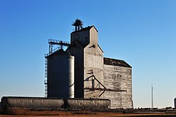 The Former Saskatchewan Wheat Pool grain elevator in Chaplin | |
 Chaplin Location of Chaplin in Saskatchewan | |
| Coordinates: 50°16′23″N 106°23′28″W / 50.273°N 106.391°W | |
| Country | |
| Province | |
| Region | |
| Census division | 7 |
| Rural Municipality | Chaplin |
| Government | |
| • Type | Municipal |
| • Governing body | Chaplin Village Council |
| • Mayor | Gary Adrian |
| • Administrator | Raegan Funk |
| Area | |
| • Land | 1.26 km2 (0.49 sq mi) |
| Population (2016) | |
| • Total | 229 |
| • Density | 182.0/km2 (471/sq mi) |
| Time zone | UTC-6 (CST) |
| Postal code | S0H 0V0 |
| Area code(s) | 306 |
| Highways | |
| Railways | Canadian Pacific Railway |
| Website | Village of Chaplin |


Chaplin (2016 population: 229) is a village in the Canadian province of Saskatchewan within the Rural Municipality of Chaplin No. 164 and Census Division No. 7. The community is situated on the Trans-Canada Highway approximately 85 km from Moose Jaw and 90 km from Swift Current. The main industries of Chaplin are Saskatchewan Minerals and farming/ranching. Chaplin consists of eight streets, two crescents, and four avenues (including the avenue on the 'other side of the (train) tracks').
History[]
Chaplin incorporated as a village on October 8, 1912.[1]
Geography[]
Chaplin is situated on the Trans-Canada Highway between Moose Jaw and Swift Current, and on the north edge of . The lake encompasses nearly 20 square miles (52 km2).
Demographics[]
In the 2016 Census of Population conducted by Statistics Canada, the Village of Chaplin recorded a population of 229 living in 111 of its 146 total private dwellings, a 4.8% change from its 2011 population of 218. With a land area of 1.26 km2 (0.49 sq mi), it had a population density of 181.7/km2 (470.7/sq mi) in 2016.[4]
In the 2011 Census of Population, the Village of Chaplin recorded a population of 218, a -7.2% change from its 2006 population of 235. With a land area of 1.26 km2 (0.49 sq mi), it had a population density of 173.0/km2 (448.1/sq mi) in 2011.[5]
Government[]
Chaplin is governed by an elected Mayor and five councilors. The village employs a Village Administrator, Village Foreperson, and on Saturdays an additional individual works at the Village Dump administering public waste disposal (there is also weekly curb-side trash pick-up).
Climate[]

| Climate data for Chaplin | |||||||||||||
|---|---|---|---|---|---|---|---|---|---|---|---|---|---|
| Month | Jan | Feb | Mar | Apr | May | Jun | Jul | Aug | Sep | Oct | Nov | Dec | Year |
| Record high °C (°F) | 11.5 (52.7) |
15 (59) |
23.9 (75.0) |
32.8 (91.0) |
36.7 (98.1) |
42.8 (109.0) |
40.6 (105.1) |
42.8 (109.0) |
38.9 (102.0) |
30.6 (87.1) |
22.2 (72.0) |
17.8 (64.0) |
42.8 (109.0) |
| Average high °C (°F) | −8 (18) |
−5.1 (22.8) |
2.3 (36.1) |
11.4 (52.5) |
18.5 (65.3) |
23.2 (73.8) |
25.6 (78.1) |
24.9 (76.8) |
18.4 (65.1) |
11.8 (53.2) |
0.4 (32.7) |
−6.3 (20.7) |
9.8 (49.6) |
| Daily mean °C (°F) | −13 (9) |
−10.1 (13.8) |
−3 (27) |
5 (41) |
11.8 (53.2) |
16.5 (61.7) |
18.8 (65.8) |
17.9 (64.2) |
11.7 (53.1) |
5.5 (41.9) |
−4.5 (23.9) |
−11.3 (11.7) |
3.8 (38.8) |
| Average low °C (°F) | −17.8 (0.0) |
−15 (5) |
−8.2 (17.2) |
−1.5 (29.3) |
5 (41) |
9.8 (49.6) |
11.9 (53.4) |
10.9 (51.6) |
4.9 (40.8) |
−0.8 (30.6) |
−9.2 (15.4) |
−16.2 (2.8) |
−2.2 (28.0) |
| Record low °C (°F) | −47.2 (−53.0) |
−44.4 (−47.9) |
−41.7 (−43.1) |
−26.7 (−16.1) |
−13.9 (7.0) |
−6.7 (19.9) |
1.1 (34.0) |
−2.2 (28.0) |
−12.2 (10.0) |
−26.1 (−15.0) |
−40 (−40) |
−40.6 (−41.1) |
−47.2 (−53.0) |
| Average precipitation mm (inches) | 14 (0.6) |
15.7 (0.62) |
20.2 (0.80) |
19.7 (0.78) |
53.5 (2.11) |
60.4 (2.38) |
62.3 (2.45) |
47.1 (1.85) |
35 (1.4) |
13.6 (0.54) |
11.9 (0.47) |
19.3 (0.76) |
386.3 (15.21) |
| Source: Environment Canada[6] | |||||||||||||
See also[]
- List of communities in Saskatchewan
- Villages of Saskatchewan
References[]
- ^ "Urban Municipality Incorporations". Saskatchewan Ministry of Government Relations. Archived from the original on 15 October 2014. Retrieved 1 June 2020.
- ^ "Saskatchewan Census Population" (PDF). Saskatchewan Bureau of Statistics. Archived from the original (PDF) on 24 September 2015. Retrieved 31 May 2020.
- ^ "Saskatchewan Census Population". Saskatchewan Bureau of Statistics. Retrieved 31 May 2020.
- ^ "Population and dwelling counts, for Canada, provinces and territories, and census subdivisions (municipalities), 2016 and 2011 censuses – 100% data (Saskatchewan)". Statistics Canada. 8 February 2017. Retrieved 30 May 2020.
- ^ "Population and dwelling counts, for Canada, provinces and territories, and census subdivisions (municipalities), 2011 and 2006 censuses (Saskatchewan)". Statistics Canada. 3 June 2019. Retrieved 30 May 2020.
- ^ Environment Canada Canadian Climate Normals 1971–2000, accessed 24 July 2010
Places adjacent to Chaplin, Saskatchewan | ||||||||||||||||
|---|---|---|---|---|---|---|---|---|---|---|---|---|---|---|---|---|
| ||||||||||||||||
| Subdivisions | |
|---|---|
| Communities |
|
| Cities |
|
| Villages |
|
| Topics |
|
| |
Division No. 7, Saskatchewan | |||||
|---|---|---|---|---|---|
| Cities |
|  | |||
| Towns |
| ||||
| Villages | |||||
| Resort villages | |||||
| Rural municipalities | |||||
| Unincorporated communities |
| ||||
Coordinates: 50°27′37.33″N 106°39′17.28″W / 50.4603694°N 106.6548000°W
- Villages in Saskatchewan
- Chaplin No. 164, Saskatchewan
- Division No. 7, Saskatchewan