Chiemgau Alps
This article does not cite any sources. (March 2019) |
| Chiemgau Alps | |
|---|---|
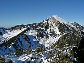 Geigelstein (1808 m) seen from the southern peak Breitenstein | |
| Highest point | |
| Peak | Sonntagshorn |
| Elevation | 1,961 m (6,434 ft) |
| Geography | |
| Countries | Germany and Austria |
| States | Bavaria, Salzburg and Tirol |
| Parent range | Northern Limestone Alps |
| Geology | |
| Orogeny | Alpine orogeny |
| Age of rock | Mesozoic and Cenozoic |
| Type of rock | sedimentary rocks |
The Chiemgau Alps (German: Chiemgauer Alpen) are a mountain range in the Northern Limestone Alps and therefore belong to the Eastern Alps. Their major part is situated in Bavaria, Germany and only a small section crosses the Austrian border into the states of Salzburg and Tirol. They reach their highest elevation (1961 m) in the Sonntagshorn, a peak straddling the German-Austrian border.
Geography[]
The Chiemgau Alps stretch from the Inn River in the West to the Salzach River in the East and cover a distance of 60 km in strike direction; their maximum width in North-South direction amounts to about 25–30 km. They are surrounded by the following mountain ranges:
- Bavarian Prealps in the West
- Kaisergebirge in the Southwest
- Leoganger Steinberge in the South
- Loferer Steinberge in the Southeast
- Berchtesgaden Alps in the Southeast and East
Their northern edge often drops off quite drastically to the foothills.
Major peaks[]
- Sonntagshorn - 1,961 m
- - 1,869 m
- Geigelstein - 1,808 m
- Zwiesel - 1,781 m
- Dürrnbachhorn - 1,776 m
- Hochstaufen - 1,771 m
- - 1,764 m
- Hochgern - 1,744 m
- Rauschberg - 1,671 m
- Hochries - 1,569 m
- Ristfeuchthorn - 1,569 m
- Klausenberg - 1,548 m
- Unternberg - 1,425 m
- Heuberg - 1,338 m
Peaks for rock climbing:
- Hörndlwand 1684 m
- Kampenwand 1664 m
Coordinates: 47°43′N 12°33′E / 47.717°N 12.550°E

| Authority control |
|---|
- Chiemgau Alps
- Mountain ranges of the Alps
- Mountain ranges of Tyrol (state)
- Mountain ranges of Bavaria
- Mountain ranges of Salzburg (state)
- Northern Limestone Alps