Ybbstal Alps
| Ybbstal Alps | |
|---|---|
 | |
| Highest point | |
| Peak | Hochstadl |
| Elevation | 1,919 m (6,296 ft) |
| Geography | |
 Location of the Ybbstal Alps | |
| Country | Austria |
| States | Upper Austria, Lower Austria, Styria |
| Range coordinates | 47°41′07″N 15°04′29″E / 47.68528°N 15.07472°ECoordinates: 47°41′07″N 15°04′29″E / 47.68528°N 15.07472°E |
| Parent range | Northern Limestone Alps |

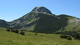
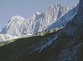
The Ybbstal Alps (German: Ybbstaler Alpen) are a mountain range of the Northern Limestone Alps and part of the Eastern Alps, located in Austria.
They occupy an area along the borders of the states of Upper Austria, Lower Austria and Styria. The range includes the eastern part of the , as well as the and the Kräuterin in the south.
The are home to the popular skiing area at Hochkar (1,808 metres). Their highest peak is the Hochstadl, at 1,919 m (6,296 ft) above sea level.
Another popular mountain is the Dürrenstein at 1,878 m.
References[]
show This article may be expanded with text translated from the corresponding article in German. (December 2009) Click [show] for important translation instructions. |
| show Mountain ranges of the Northern Limestone Alps |
|---|
| show Authority control |
|---|
This Austrian location article is a stub. You can help Wikipedia by . |
Categories:
- Northern Limestone Alps
- Mountain ranges of the Alps
- Mountain ranges of Lower Austria
- Mountain ranges of Upper Austria
- Mountain ranges of Styria
- Austria geography stubs