Totes Gebirge
This article does not cite any sources. (December 2009) |
show This article may be expanded with text translated from the corresponding article in German. (November 2016) Click [show] for important translation instructions. |
| Totes Gebirge | |
|---|---|
 Aerial photo of Totes Gebirge | |
| Highest point | |
| Peak | Großer Priel |
| Elevation | 2,515 m (8,251 ft) |
| Coordinates | 47°43′1″N 14°3′48″E / 47.71694°N 14.06333°ECoordinates: 47°43′1″N 14°3′48″E / 47.71694°N 14.06333°E |
| Geography | |
 Totes Gebirge (in red) within the Alps.
The borders of the range according to Alpine Club classification of the Eastern Alps | |
| Country | Austria |
| States | Styria and Upper Austria |
| Parent range | Northern Limestone Alps |


Panoramic view of Totes Gebirge
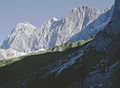
The Totes Gebirge is a group of mountains in Austria, part of the Northern Limestone Alps, lying between the Salzkammergut and the Ennstaler Alpen. The name Totes Gebirge is derived from the German words tot meaning "dead", referring to the apparent lack of vegetation, and Gebirge meaning "mountain range". The area is a large karst plateau with steep sides, and several mountain peaks above 2000 m. The highest point is the summit of Großer Priel, at 2,515 metres (8,251 ft)
See also[]
| show Mountain ranges of the Northern Limestone Alps |
|---|
| show Authority control |
|---|
This Styria location article is a stub. You can help Wikipedia by . |
This Upper Austria location article is a stub. You can help Wikipedia by . |
Categories:
- Totes Gebirge
- Mountain ranges of the Alps
- Northern Limestone Alps
- Mountain ranges of Styria
- Upper Austrian Prealps
- Styria geography stubs
- Upper Austria geography stubs