Chignik Fisheries Airport
Chignik Fisheries Airport | |||||||||||
|---|---|---|---|---|---|---|---|---|---|---|---|
 | |||||||||||
| Summary | |||||||||||
| Airport type | Public | ||||||||||
| Serves | Chignik, Alaska | ||||||||||
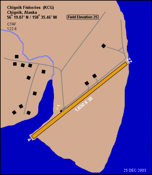
| Elevation AMSL | 25 ft / 8 m | ||||||||||
| Coordinates | 56°19′04″N 158°35′27″W / 56.31778°N 158.59083°W | ||||||||||
| Map | |||||||||||
 KCG Location of airport in Alaska | |||||||||||
| Runways | |||||||||||
| |||||||||||
Source: Federal Aviation Administration[1] | |||||||||||

Chignik Fisheries Airport (IATA: KCG[2], FAA LID: KCG) was a public-use airport located 6 nautical miles (11 km) northwest of Chignik,[1] a city in the Lake and Peninsula Borough of the U.S. state of Alaska.
Facilities and aircraft[]
Chignik Fisheries Airport had one runway designated 4/22 with a gravel surface measuring 1,630 by 30 feet (497 x 9 m). The airport had an average of 33 aircraft operations per month: 62% air taxi and 37% general aviation.[1]
See also[]
- Chignik Airport (IATA: KCG, ICAO: PAJC, FAA LID: AJC)
- Chignik Bay Seaplane Base (IATA: KBW, FAA LID: Z78)
- Chignik Lagoon Airport (IATA: KCL, FAA LID: KCL)
- Chignik Lake Airport (IATA: KCQ, FAA LID: A79)
References[]
- ^ a b c "KCG - Chignik Fisheries Airport - FAA information effective 25 December 2003". FAA data republished by AirNav. Archived from the original on 3 February 2004.
- ^ KCG: Chignik Fisheries Airport, Alaska. Aviation Safety Network. Retrieved 7 Sep 2009.
External links[]
- Airport diagram for Chignik Fisheries (KCG), Chignik, Alaska (GIF). FAA, Alaska Region. 25 Dec 2003.
- Aeronautical chart showing former location of airport. SkyVector. Retrieved 7 Sep 2009.
This article about an Alaska airport is a stub. You can help Wikipedia by . |
Categories:
- Airports in Lake and Peninsula Borough, Alaska
- Alaska airport stubs