Talkeetna Airport
Talkeetna Airport | |||||||||||
|---|---|---|---|---|---|---|---|---|---|---|---|
| |||||||||||
| Summary | |||||||||||
| Airport type | Public | ||||||||||
| Owner | State of Alaska DOT&PF - Central Region | ||||||||||
| Serves | Talkeetna, Alaska | ||||||||||
| Elevation AMSL | 358 ft / 109 m | ||||||||||
| Coordinates | 62°19′14″N 150°05′37″W / 62.32056°N 150.09361°WCoordinates: 62°19′14″N 150°05′37″W / 62.32056°N 150.09361°W | ||||||||||
| Map | |||||||||||
 TKA Location of airport in Alaska | |||||||||||
| Runways | |||||||||||
| |||||||||||
| Helipads | |||||||||||
| |||||||||||
| Statistics (2009) | |||||||||||
| |||||||||||
Source: Federal Aviation Administration[1] | |||||||||||

Talkeetna Airport (IATA: TKA, ICAO: PATK, FAA LID: TKA) is a state-owned public-use airport located one nautical mile (2 km) east of the central business district of Talkeetna, in the Matanuska-Susitna Borough of the U.S. state of Alaska.[1]
This airport is included in the National Plan of Integrated Airport Systems for 2011–2015, which categorized it as a general aviation airport.[2] As per Federal Aviation Administration records, the airport had 1,150 passenger boardings (enplanements) in calendar year 2008.[3]
The airport is home to at least seven air taxi operations, and is very busy during tourist season because of its proximity to Denali.[4] Air services operating from the airport include Sheldon Air Service, Talkeetna Aero Services, K2 Aviation, and Talkeetna Air Taxi.
Facilities and aircraft[]
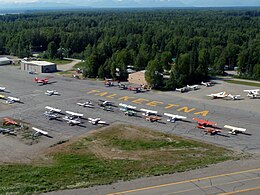
Talkeetna Airport covers an area of 624 acres (253 ha) at an elevation of 358 feet (109 m) above mean sea level. Its one runway is designated 18/36 and has an asphalt pavement measuring 3,500 by 75 feet (1,067 x 23 m). It also has one helipad designated H1 with a gravel surface measuring 480 by 85 feet (146 x 26 m).[1]
For the 12-month period ending December 31, 2009, the airport had 30,000 aircraft operations, an average of 82 per day: 67% general aviation, 32% air taxi, and 2% military. At that time there were 25 aircraft based at this airport: 96% single-engine, and 4% multi-engine.[1]
References[]
- ^ a b c d FAA Airport Form 5010 for TKA PDF. Federal Aviation Administration. effective August 25, 2011.
- ^ "2011–2015 NPIAS Report, Appendix A (PDF, 2.03 MB)" (PDF). National Plan of Integrated Airport Systems. Federal Aviation Administration. October 4, 2010.
- ^ "Enplanements for CY 2008 (PDF, 1.0 MB)" (PDF). CY 2008 Passenger Boarding and All-Cargo Data. Federal Aviation Administration. December 18, 2009.
- ^ http://www.talkeetnachamber.org/news.php?id=10&PHPSESSID=fa916cc8c592a55166c6bad4b4c0f2c0[dead link]
External links[]
- Topographic map from USGS The National Map
- FAA Terminal Procedures for TKA, effective February 24, 2022
- Resources for this airport:
- FAA airport information for TKA
- AirNav airport information for PATK
- ASN accident history for TKA
- FlightAware airport information and live flight tracker
- NOAA/NWS latest weather observations for PATK
- SkyVector aeronautical chart for TKA
This article about an Alaska airport is a stub. You can help Wikipedia by . |
This article about a location in the Matanuska-Susitna Borough, Alaska is a stub. You can help Wikipedia by . |
- Airports in Matanuska-Susitna Borough, Alaska
- Alaska airport stubs
- Matanuska-Susitna Borough, Alaska geography stubs