Napakiak Airport
Napakiak Airport | |||||||||||
|---|---|---|---|---|---|---|---|---|---|---|---|
 | |||||||||||
| Summary | |||||||||||
| Airport type | Public | ||||||||||
| Owner | State of Alaska DOT&PF - Central Region | ||||||||||
| Serves | Napakiak, Alaska | ||||||||||
| Elevation AMSL | 17 ft / 5 m | ||||||||||
| Coordinates | 60°41′25″N 161°58′43″W / 60.69028°N 161.97861°W | ||||||||||
| Map | |||||||||||
 WNA Location of airport in Alaska | |||||||||||
| Runways | |||||||||||
| |||||||||||
| Statistics | |||||||||||
| |||||||||||

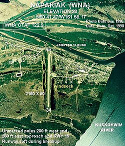
Napakiak Airport (IATA: WNA, ICAO: PANA, FAA LID: WNA) is a state-owned, public-use airport located in Napakiak, a city in the Bethel Census Area of the U.S. state of Alaska.[1]
As per Federal Aviation Administration records, Napakiak Airport had 1,840 passenger boardings (enplanements) in calendar year 2008, an increase of 0.7% from the 1,828 enplanements in 2007.[2] Napakiak Airport is included in the FAA's National Plan of Integrated Airport Systems (2009–2013), which categorizes it as a general aviation facility.[3]
Facilities[]
Napakiak Airport has one runway designated 16/34 with a gravel surface measuring 3,248 by 60 feet (990 x 18 m). The airport is unattended.[1]
Remarks:[1]
- Runway 16/34 south 1500-feet 6-inch dips.
- Activate rotating beacon - CTAF
- Activate MIRL runway 16/34, REIL runways 16 & 34 - CTAF.
- Seaplane Base operated in river; Johnson Slough unusable.
- Runway condition not monitored; recommend visual inspection prior to using.
- Windsock unreliable.
- Weather camera available on internet at https://web.archive.org/web/20090831040305/http://akweathercams.faa.gov/
- This airport has been surveyed by the National Geodetic Survey.
- Seaplane Base ASP: established prior to 1959.
References[]
- ^ a b c d FAA Airport Form 5010 for WNA PDF. Federal Aviation Administration. effective 27 Aug 2009.
- ^ a b CY 2008 Passenger Boarding and All-Cargo Data (Preliminary). Federal Aviation Administration. Published 15 July 2009.
- ^ FAA National Plan of Integrated Airport Systems: 2009-2013. Federal Aviation Administration. Published 1 Oct 2008.
External links[]
- FAA Alaska airport diagram (GIF)
- FAA Terminal Procedures for WNA, effective February 24, 2022
- Resources for this airport:
- Airport information for PANA at AirNav
- Accident history for WNA at Aviation Safety Network
- Aeronautical chart and airport information for WNA at SkyVector
This article about an Alaska airport is a stub. You can help Wikipedia by . |
- Airports in the Bethel Census Area, Alaska
- Alaska airport stubs