China–Laos border


The China–Laos border is the international boundary between China and Laos, which runs for 505 km from the tripoint with Myanmar in the west to the tripoint with Vietnam in the east.[1]
Description[]
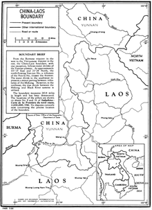
The border starts in the west at the tripoint with Myanmar on the Mekong river, proceeding southwards via a series of irregular overland lines. The border then turns sharply eastward and continues overland, before turning sharply northward, continuing in that direction for some distance, before again turning eastward and terminating at the Vietnamese tripoint at the Shiceng Dashan peak.[2]
The border on both sides is predominantly inhabited by minority people groups.[3] Topographically it is mountainous and forested, with some limited agriculture.[3] On the Laotian side the border lie the provinces of Luang Namtha, Oudomxai and Phongsali, whilst the entirety of China's side belongs to the province of Yunnan.
History[]
The border area was historically remote from the centres of both Chinese and Lao power.[3] From the 1860s France began establishing a presence in the region, initially in modern Cambodia and Vietnam, and the colony of French Indochina was created in 1887.[3] France and China had already determined the border between Tonkin (northern Vietnam) and China in 1887 following the Sino-French War.[3] Laos was then added to the colony in 1893 following the Franco-Siamese War, and a border agreement delimiting the China-Laos boundary at its current position was signed on 20 June 1895.[4][5] It was later demarcated on the ground with a series of pillars.[3]
Laos obtained a partial independence from France in 1949, around the time when Mao Zedong established the People's Republic of China after defeating Chiang Kai Shek's nationalist government in the Chinese Civil War. Consequently, China's adaptation of Stalinist principles in the form of Maoism influenced Laotian politics, fuelling demands for total independence from France, which was granted in 1953.[6] The boundary then became one between two sovereign independent states. The border was re-surveyed and demarcated in April 1992.[7]
Border crossings[]
There are two border crossings. The main one is located at Mohan-Boten.[8] A second crossing is at further northeast (only for Chinese and Laotian citizens).[8] There is no railway crossing the border, but the Vientiane–Boten railway and the Yuxi–Mohan railway are under construction and will connect Kunming with Vientiane when completed in 2021.[9]
Historical maps[]
Historical maps of the border from west to east in the International Map of the World, Operational Navigation Chart and Tactical Pilotage Chart, late 20th century:


See also[]
References[]
- ^ "Laos". CIA World Factbook. Retrieved 17 September 2020.
- ^ China, Vietnam and Laos Sign the Treaty on Definition of the Tri-Junction Point of the National Boundaries[permanent dead link]
- ^ a b c d e f "International Boundary Study No. 34 – China – Laos Boundary" (PDF). US Department of State. 24 June 1964. Retrieved 17 September 2020.
- ^ Stuart-Fox, Martin (1997). A History of Laos. Cambridge University Press. pp. 24–25. ISBN 0-521-59746-3.
- ^ Simms, Peter; Simms, Sanda (2001). The Kingdoms of Laos: Six Hundred Years of History. Psychology Press. pp. 206–207. ISBN 0700715312. Retrieved 22 August 2015.
- ^ "Laos – Encyclopædia Britannica Overview". Encyclopædia Britannica. Retrieved 23 January 2011.
- ^ St John, Ronald Bruce. "The Land Boundaries of Indochina: Cambodia, Laos and Vietnam" (PDF). International Boundaries Research Unit, Department of Geography, University of Durham. Archived from the original (PDF) on 13 November 2020. Retrieved 17 September 2020.
- ^ a b "Laos Border Checkpoints". ITI Holiday. Retrieved 17 September 2020.
- ^ "China's rail network opens up transport links in Laos". The Star. 20 Jan 2020.
- China–Laos border
- China–Laos relations
- Borders of China
- Borders of Laos
- International borders