China–Myanmar border
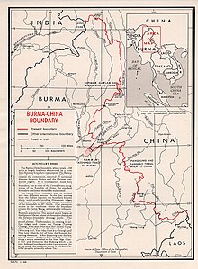
The China–Myanmar border is the international border between the territory of the People's Republic of China and Myanmar (formerly Burma). The border is 2,129 km (1,323 mi) in length and run from the tripoint with India in the north to the tripoint with Laos in the south.[1]
Description[]
The border begins in the north at the tripoint with India near just north of the Diphu Pass[a] and then runs briefly to north-east, across the Nanmi Pass and Hkakabo Razi (5881 m), the highest mountain in Southeast Asia. It then turns to the south-east, running broadly southwards and then south-westwards across the Hengduan and Gaoligong Mountains via a series of irregular lines. In the vicinity of Ruili the border briefly utilises parts of the Taping and Nanwan rivers, before turning south-east to join the Shweli River, which it utilises for a period towards the north-east. The border then continues through mountainous terrain in a broadly (though often convoluted) south-eastwards direction, occasionally utilising rivers (such as the Nanding and Nam Hka) for short stretches, before turning to the east in the southern stretch up to the Mekong river, and then utilising that river down to the tripoint with Laos.
History[]

The boundary area is inhabited by non-Han and non-Burmese peoples, and has been traditionally kept as a buffer region between the various Chinese and Burmese empires.[2] During the 19th century the British, based in India, began occupying Myanmar (then referred to as Burma), gradually incorporating it into British India.[2] Their advance close to lands traditionally claimed by China pushed the two sides into negotiating a boundary treaty in 1894, which covered the southern half of the boundary as far north as the vicinity of Myitkyina, exclusive of the Wa States.[2] Sections of this border were demarcated and marked on the ground from 1897 to 1900.[2] In 1941 a border running through the Wa States area was agreed upon following on-the-ground surveys conducted in the 1930s, though no agreement on the northern stretch was reached, with China claiming much of what is now northern Myanmar.[2] Meanwhile, in 1937 Burma was separated from India and became a separate colony, gaining full independence in 1948.
During the Second World War the Burma Road was constructed across the border as an Allied supply line for the Chinese forces fighting Japan.[3] In 1941, following Japan's invasion of Burma, parts of Burma were ceded to Siam as the Saharat Thai Doem territory, thereby giving China a common border with Thailand, however these areas were returned to Burma in 1946 following Japan's defeat.[2][4][5]
1960 Border settlement[]
Discussions between Burma and China (now under Communist rule) over the border began in 1954, with China keen to control the area more effectively as it was being used as a base by Kuomintang troops.[2] On 28 January 1960 a treaty was signed which delimited most of the border, which was later completed with a full delimitation treaty signed on 1 October 1960, with both sides ceding small areas along the border.[2] The two sides then demarcated the border on the ground in the following year.[2]
Since then relations between the two states have remained largely cordial, though the border region has at times been volatile owing to the ongoing insurgencies in Myanmar's Kachin and Shan states.[6][7] In recent years several towns along the border, such as Mong La, Ruili and Muse, have become centres of gambling, prostitution and drug smuggling.[8][9][10]
Border crossings[]

Shan State:
- Guanlei River Port (Mengla County, Xishuangbanna)
- Menglong crossing (Jinghong City, Xishuangbanna) - NDAA control on Burmese side
- Mong La (NDAA control) - Daluo (Menghai County, Xishuangbanna)
- Mangxin crossing (Menglian County, Pu'er Prefecture) - NDAA control on Burmese side
- Pangkham (controlled by Wa State) - Meng'a (Menglian County, Pu'er)
- Natuoba (Wa State) - Mengka crossing (Ximeng County, Pu'er)
- Shawba (Wa State) - Mengdong (Cangyuan) crossing (Cangyuan County, Lincang Prefecture)
- Namtit (Wa State) - Mangka (Cangyuan, Lincang)
- Chinshwehaw - Qingshuihe (Gengma County, Lincang)
- Laukkai (Kokang Region) - Nansan (Zhenkang County, Lincang)
- Mong Ko - Manghai (Mangshi County, Dehong Prefecture)
- Pang Hseng - Wanding (Ruili County, Dehong)
- Muse - Ruili (Dehong)
Kachin State:
- Lweje - Zhangfeng (Longchuan County, Dehong)
- Mai Ja Yang crossing (controlled by KIO)
- Laiza (controlled by KIO) - Nabang (Yingjiang County, Dehong)
- Kan Paik Ti (NDA-K border force joint control) - Houqiao (Tengchong County, Baoshan Prefecture)
- Pangwa (NDA-K border force joint control) - Diantan (Tengchong, Baoshan)
- Bimaw - Pianma (Lushui County, Nujiang Prefecture)
Historical maps[]
Historical maps of the border from north to south in the International Map of the World, mid-late 20th century:


See also[]
Footnotes[]
- ^ The precise location of the tripoint is unclear owing to the ongoing Sino-Indian border dispute.
References[]
- ^ "Burma". CIA World Factbook. Retrieved 17 September 2020.
- ^ a b c d e f g h i "International Boundary Study No. 42 – Burma-China Boundary" (PDF). US DOS. 30 November 1964. Retrieved 17 September 2020.
- ^ Burma Road - Britannica Online Encyclopedia
- ^ Donald M. Seekins, Historical Dictionary of Burma (Myanmar), p. 251
- ^ "A Forgotten Invasion: Thailand in Shan State, 1941–45"
- ^ "More fighting feared as thousands flee Burma". Bangkok Post. Agence France-Presse. 27 August 2009. Retrieved 28 August 2009.
- ^ "Myanmar says Chinese tip-off led to border clash". Associated Press. 10 September 2009. Retrieved 11 September 2009.
- ^ Asia Times Online, Virtual gambling in Myanmar's drug country, Michael Black and Roland Fields, Aug 26, 2006
- ^ "Asia Times Online :: south-east Asia news - Virtual gambling in Myanmar's drug country". Atimes.com. 2006-08-26. Archived from the original on 2006-10-19. Retrieved 2012-11-29.CS1 maint: unfit URL (link)
- ^ "Strategic Programme Framework: Union of Myanmar 2004-2007" (PDF). United Nations Office on Drugs and Crime. Retrieved 2009-01-01.
| Wikimedia Commons has media related to China-Myanmar border. |
- China–Myanmar border
- China–Myanmar relations
- Borders of China
- Borders of Myanmar
- International borders