Ruili
Ruili
瑞丽市 | |
|---|---|
   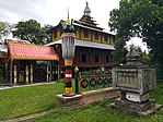 From top, left to right: Ruili City government hall, fortune center plaza, Jiegao passway of the port of entry of Ruili, Kyaung of Denghannong | |
 Ruili Location in Yunnan | |
| Coordinates: 24°01′05″N 97°51′22″E / 24.018°N 97.856°ECoordinates: 24°01′05″N 97°51′22″E / 24.018°N 97.856°E | |
| Country | People's Republic of China |
| Province | Yunnan |
| Prefecture | Dehong |
| Area | |
| • Total | 1,020 km2 (390 sq mi) |
| Elevation | 777 m (2,549 ft) |
| Population | |
| • Total | 270,000 |
| • Density | 260/km2 (690/sq mi) |
| Time zone | UTC+8 (China Standard) |
| Postal code | 678600 |
| Area code(s) | 0692 |
| Website | www.rl.gov.cn www.rlr.gov.cn |

Ruili (simplified Chinese: 瑞丽; traditional Chinese: 瑞麗; pinyin: Ruìlì; Tai Nuea: ᥛᥫᥒᥰ ᥛᥣᥝᥰ; Shan: မိူင်းမၢဝ်း; Thai: เมืองมาว; Burmese: ရွှေလီ) is a county-level city of Dehong Prefecture, in the west of Yunnan province, People's Republic of China. It is a major border crossing between China and Myanmar, with the town of Muse located across the border.
Name[]
The city is named after the Shweli River. 瑞 ruì means "auspicious", and 丽 lì means "beautiful". An older name of Ruili is Měngmǎo (勐卯), from Dai language "foggy place".[1]
Geography[]
Ruili is on the border with Myanmar. 64% of the population of Ruili are members of five highland and lowland ethnic minorities including Dai, Jingpo, Deang, Lisu, Achang. It is an important location for trade with Myanmar, in both legal and illegal goods and services. Prostitution and drug trade in the city are not uncommon.[2][3]
Ruili has a warm humid subtropical climate (Köppen Cwa), and is generally humid. Summer is long and there is virtually no "winter" as such; instead, there is a dry season (December through April) and wet season (May through October). A drier heat prevails from February thru early May before the onset of the monsoon from the Indian Ocean. The monthly 24-hour average temperature ranges from 14.8 °C (58.6 °F) in January to 25.5 °C (77.9 °F) in June, while the annual mean is 21.6 °C (70.9 °F). Rainfall totals about 1,450 mm (57 in) annually, with nearly 70% of it occurring from June to September.
Bordered by monsoon evergreen broad-leaved forest, Ruili Botanical Garden is just north of the City and covers 5,000 acres of well-preserved native vegetation.
| Climate data for Ruili (1971−2000) | |||||||||||||
|---|---|---|---|---|---|---|---|---|---|---|---|---|---|
| Month | Jan | Feb | Mar | Apr | May | Jun | Jul | Aug | Sep | Oct | Nov | Dec | Year |
| Record high °C (°F) | 26.9 (80.4) |
31.3 (88.3) |
33.8 (92.8) |
36.3 (97.3) |
36.4 (97.5) |
36.3 (97.3) |
33.8 (92.8) |
34.4 (93.9) |
34.8 (94.6) |
32.9 (91.2) |
30.9 (87.6) |
27.3 (81.1) |
36.4 (97.5) |
| Average high °C (°F) | 22.8 (73.0) |
25.0 (77.0) |
28.7 (83.7) |
30.7 (87.3) |
30.4 (86.7) |
29.3 (84.7) |
28.3 (82.9) |
28.8 (83.8) |
29.1 (84.4) |
28.2 (82.8) |
25.3 (77.5) |
22.7 (72.9) |
27.4 (81.4) |
| Daily mean °C (°F) | 14.8 (58.6) |
16.8 (62.2) |
20.3 (68.5) |
23.3 (73.9) |
24.9 (76.8) |
25.5 (77.9) |
25.0 (77.0) |
25.2 (77.4) |
24.9 (76.8) |
23.2 (73.8) |
19.4 (66.9) |
15.9 (60.6) |
21.6 (70.9) |
| Average low °C (°F) | 6.9 (44.4) |
8.6 (47.5) |
11.9 (53.4) |
16.0 (60.8) |
19.4 (66.9) |
21.8 (71.2) |
21.8 (71.2) |
21.7 (71.1) |
20.8 (69.4) |
18.2 (64.8) |
13.6 (56.5) |
9.1 (48.4) |
15.8 (60.5) |
| Record low °C (°F) | 1.4 (34.5) |
2.2 (36.0) |
5.5 (41.9) |
9.7 (49.5) |
13.6 (56.5) |
16.3 (61.3) |
16.5 (61.7) |
15.8 (60.4) |
15.4 (59.7) |
9.5 (49.1) |
5.2 (41.4) |
2.2 (36.0) |
1.4 (34.5) |
| Average rainfall mm (inches) | 8.8 (0.35) |
19.4 (0.76) |
22.5 (0.89) |
53.6 (2.11) |
149.1 (5.87) |
268.4 (10.57) |
323.4 (12.73) |
257.5 (10.14) |
166.9 (6.57) |
109.1 (4.30) |
63.5 (2.50) |
11.8 (0.46) |
1,454 (57.25) |
| Average rainy days (≥ 0.1 mm) | 2.7 | 4.4 | 5.6 | 11.1 | 18.2 | 24.9 | 27.4 | 24.4 | 18.8 | 13.5 | 8.4 | 3.6 | 163.0 |
| Source: Weather China | |||||||||||||
Administrative divisions[]
Ruili City has 3 towns and 3 townships.[4]
- 3 towns
- 3 townships
- Jiexiang (姐相乡)
- (户育乡)
- (勐秀乡)
Demography[]
Han Chinese and Dai mostly live in the valley, in the city; Jingpo and Deang live mostly in the outskirts in the surrounding hills.
Industrial parks[]
Wanding Border Economic Cooperation Zone (WTBECZ) is a Chinese State Council-approved Industrial Park based in Wanding Town of Ruili City founded in 1992 and was established to promote Sino–Burmese trade. The zone spans 6 km2 (2.3 sq mi) and is focused on developing trading, processing, agriculture resources and tourism.[5]
Ruili Border Economic Cooperation Zone (RLBECZ) is a Chinese State Council-approved Industrial Park based in Ruili founded in 1992 and was established to promote trade between China and Myanmar. The area's import and export trade include the processing industry, local agriculture and biological resources are very promising. Sino-Myanmar business is growing fast. Myanmar is now one of Yunnan's biggest foreign trade partners. In 1999, Sino-Myanmar trade accounted for 77.4% of Yunnan's foreign trade. In the same year, exports for electromechanical equipments came up to US$55.28 million. Main exports here include fiber cloth, cotton yarn, ceresin wax, mechanical equipments, fruits, rice seeds, fiber yarn and tobacco.[6]
Transportation[]
The Dali–Ruili Railway, which will connect Ruili with China's national railway network, is under construction.
References[]
- ^ "云南瑞丽已着手地名维权,欲促使《瑞丽》杂志注销商标" (in Chinese). thepaper.cn. 9 August 2015. Retrieved 27 January 2019.
- ^ Moe, Kyaw Zwa (January 2005). "Yunnan's Sin City". The Irrawaddy. Chiang Mai, Thailand. Archived from the original on January 24, 2011. Retrieved June 30, 2014.CS1 maint: unfit URL (link)
- ^ Sex, Drugs and The Roll of Dice, Time Asia, September 27, 1999
- ^ "国家统计局" (in Chinese). National Bureau of Statistics of the People's Republic of China. Retrieved 2021-12-07.
- ^ RightSite.asia | Wanding Border Economic Cooperation Zone
- ^ RightSite.asia | Ruili Border Economic Cooperation Zone
External links[]
| Wikimedia Commons has media related to Ruili City. |
| |||||||||||||||||||||||||||||||||||||||||||||||||||||||||||||||||||||||||||


- Ruili
- County-level divisions of Dehong Prefecture
- China–Myanmar border crossings
- Cities in Yunnan