Ninglang Yi Autonomous County
This article does not cite any sources. (June 2021) |
Ninglang County | |
|---|---|
| 宁蒗彝族自治县 · ꆀꆿꆈꌠꊨꏦꏱꅉꑤ Ninglang Yi Autonomous County | |
 | |
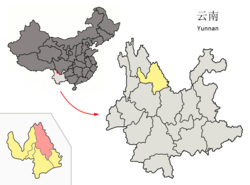 Location of Ninglang County (pink) and Lijiang City (yellow) within Yunnan | |
| Country | People's Republic of China |
| Province | Yunnan |
| Prefecture-level city | Lijiang |
| Area | |
| • Total | 6,206 km2 (2,396 sq mi) |
| Population | |
| • Total | 230,000 |
| • Density | 37/km2 (96/sq mi) |
| Time zone | UTC+8 (CST) |
| Postal code | 674300 |
| Area code(s) | 0888 |
| Climate | Cwb |
Ninglang Yi Autonomous County (simplified Chinese: 宁蒗彝族自治县; traditional Chinese: 寧蒗彝族自治縣; pinyin: Nínglàng Yízú Zìzhìxiàn; Yi: ꆀꆿꆈꌠꊨꏦꏱꅉꑤ nip lat nuo su zyt jie jux dde xiep) is located in the northwest of Yunnan province, China, bordering Sichuan province to the northeast. It is under the administration of Lijiang City. The county is home to the Mosuo people, who lived under the quasi-independent Chiefdom of Yongning until abolished in 1956. Ninglang Luguhu Airport is located in the county.
Climate[]
| showClimate data for Ninglang (1981−2010) |
|---|
External links[]
| show Authority control |
|---|
Coordinates: 27°17′02″N 100°51′36″E / 27.28389°N 100.86000°E

This Yunnan location article is a stub. You can help Wikipedia by . |
Categories:
- Ninglang Yi Autonomous County
- County-level divisions of Lijiang
- Yi autonomous counties
- Yunnan geography stubs