Yuxi
Yuxi
玉溪市 | |
|---|---|
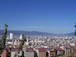 Hongta District, 2007 | |
 Location of Yuxi in Yunnan | |
| Coordinates (Yuxi municipal government): 24°20′49″N 102°31′37″E / 24.347°N 102.527°ECoordinates: 24°20′49″N 102°31′37″E / 24.347°N 102.527°E | |
| Country | People's Republic of China |
| Province | Yunnan |
| Admin HQ | Hongta |
| Area | |
| • Total | 15,285 km2 (5,902 sq mi) |
| Population | |
| • Total | 2,568,000 |
| • Density | 170/km2 (440/sq mi) |
| Time zone | UTC+8 (China Standard) |
| Postal code | 653100 |
| Area code(s) | 0877 |
| ISO 3166 code | CN-YN-04 |
| Website | www |
| Yunnan e-Portal | |

Yuxi (Chinese: 玉溪; pinyin: Yùxī) is a prefecture-level city in the central part of Yunnan province of the People's Republic of China. The administrative center of Yuxi is Hongta District. Yuxi is approximately 90 kilometres (56 mi) south of Kunming.
Geography[]
Yuxi is located in the center of Yunnan province, about 90 kilometres (56 mi) south of Kunming, the provincial capital. Like much of the central and eastern parts of the province, it is part of the Yunnan-Guizhou Plateau.
The area is 15,285 km2 (5,902 sq mi) and the population is approximately 2.5 million.
Near Yuxi city is Fuxian Lake, the second-deepest freshwater lake in China, where there have been discovered ancient fossils that are now in the possession of the Yuxi museum. There also are three other lakes around the city. They are Xingyun Lake, Qilu Lake, Yangzong Lake.
Climate[]
Tempered by the low latitude and moderate elevation, Yuxi has a mild subtropical highland climate (Köppen Cwb), with short, mild, dry winters, and warm, rainy summers. Frost may occur in winter but the days still generally warm up to around 17 °C (63 °F). During summer, a majority of the days features some rainfall, and daytime temperatures rise to 26 °C (79 °F). A great majority of the year's rainfall occurs from June to October.
| showClimate data for Yuxi (1981−2010) |
|---|
Transport[]
- China National Highway 213
- Kunming–Yuxi Railway and Yuxi–Mengzi Railway (sections of the Kunming–Hekou standard-gauge mainline)
- (Built in 2016,and is a part of )
History[]
The city was founded in 960 AD, at a time when Yunnan was not yet part of China. Yuxi was once the core area of Yunnan Province during the Previous Qin Dynasty (period before 221 BC). In the Western Han Dynasty (206 BC-24 AD), it became a county of Yizhou Shire. The following dynasties witnessed the continuous separations and unifications of the area. It was not until 1997 that Yuxi became a prefecture-level city of the People's Republic of China.[1]
Demography[]

A considerable part of the residents of Yuxi (around 31.76%, Year 2003) belong to ethnic minorities.
Government[]
Rao Nanhu is the mayor of Yuxi City.
People[]
The composer of China's National Anthem, Nie Er was from Yuxi.
Economy[]

Yuxi is the home of the Hongta Group, which was named after the Red Pagoda which sits atop a nearby hill. The Pagoda was originally white, but was painted red during the cultural revolution. The tobacco is of high quality because there are over 2300 hours of sunlight a year in the region, adequate rainfall in the summer, and excellent soil that produces a plethora of other fruits and vegetables. The region has begun producing wine, which could prove to be quite palatable in the next decade or so. There are substantial mineral deposits of tin and phosphate ores, including the Heavenly Triangle of Huaning,[2] Jiangchuan and Chengjiang.
Yuxi is one of the fastest growing small cities in China. In 2001, the city won an Honor Award in Analysis & Planning by the American Society of Landscape Architects. In 2004 UNIDO held a Workshop on Seed Treatment Technology, one of only two in China.
Education[]
is a university located in Yuxi with almost 8000 students. It was founded in 1978 as Yuxi Normal College. In 2000, under the approval from the Ministry of Education of the People's Republic of China, it was renamed Yuxi Normal University, with the merging of Yuxi Adult Education Center and Yuxi Normal School.
Subdivisions[]
| Map | |||||
|---|---|---|---|---|---|
| Name | Hanzi | Hanyu Pinyin | Population (2010) |
Area (km2) | Density (/km2) |
| Hongta District | 红塔区 | Hóngtǎ Qū | 495,129 | 1,004 | 493 |
| Jiangchuan District | 江川区 | Jiāngchuān Qū | 280,889 | 850 | 330 |
| Chengjiang | 澄江市 | Chéngjiāng shì | 169,366 | 773 | 219 |
| Tonghai County | 通海县 | Tōnghǎi Xiàn | 300,800 | 721 | 417 |
| Huaning County | 华宁县 | Huáníng Xiàn | 214,650 | 1,313 | 163 |
| Yimen County | 易门县 | Yìmén Xiàn | 177,110 | 1,571 | 113 |
| Eshan Yi Autonomous County | 峨山彝族自治县 | Éshān Yízú Zìzhìxiàn | 162,831 | 1,972 | 83 |
| Xinping Yi and Dai Autonomous County | 新平彝族傣族自治县 | Xīnpíng Yízú Dǎizú Zìzhìxiàn | 285,344 | 4,223 | 68 |
| Yuanjiang Hani, Yi and Dai Autonomous County | 元江哈尼族彝族傣族自治县 | Yuánjiāng Hānízú Yízú Dǎizú Zìzhìxiàn | 217,392 | 2,858 | 76 |

See also[]
References[]
External links[]


| show Authority control |
|---|
- Yuxi
- 960 establishments
- 10th-century establishments in China
- Cities in Yunnan