Lancang Lahu Autonomous County
Lancang County
澜沧县 | |
|---|---|
澜沧拉祜族自治县 Lancang Lahu Autonomous County | |
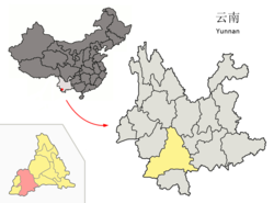 Location of Lancang County (pink) in Pu'er City (yellow) and Yunnan | |
 Lancang Location of the seat in Yunnan | |
| Coordinates: 22°33′22″N 99°55′55″E / 22.556°N 99.932°ECoordinates: 22°33′22″N 99°55′55″E / 22.556°N 99.932°E | |
| Country | People's Republic of China |
| Province | Yunnan |
| Prefecture-level city | Pu'er |
| GB/T 2260 CODE[1] | 530828 |
| Area | |
| • Total | 8,807 km2 (3,400 sq mi) |
| Elevation | 1,054 m (3,458 ft) |
| Highest elevation | 2,516 m (8,255 ft) |
| Lowest elevation | 578 m (1,896 ft) |
| Population (2004) | |
| • Total | 460,976 |
| • Density | 52/km2 (140/sq mi) |
| Time zone | UTC+8 (China Standard Time) |
| Postal code | 665600[3] |
| Area code(s) | 0879[3] |
| Website | lczw |
| 1Yunnan Statistics Bureau [1] 2Puer Gov. [2] 3Yunnan Portal [3] | |

Lancang Lahu Autonomous County (simplified Chinese: 澜沧拉祜族自治县; traditional Chinese: 瀾滄拉祜族自治縣; pinyin: Láncāng Lāhùzú Zìzhìxiàn) is an autonomous county under the jurisdiction of Pu'er City, in southwestern Yunnan province, China. Lancang is the same as Lan Xang, and refers to the Mekong River (known in Chinese as the Lancang) on its eastern borders and adopted by modern Laos, a Tai word meaning Million Elephants.
Administrative divisions[]
Lancang Lahu Autonomous County comprises five towns, nine townships and six ethnic townships.
- Towns
- Townships
- Nuofu Township (糯福乡)
- Donghe Township (东河乡)
- Dashan Township (大山乡)
- Nanling Township (南岭乡)
- Mujia Township (木戛乡)
- Laba Township (拉巴乡)
- Zhutang Township (竹塘乡)
- Fubang Township (富邦乡)
- Fudong Township (富东乡)
- Ethnic townships
- Fazhanhe Hani Ethnic Township (发展河哈尼族乡)
- Qianliu Yi Ethnic Township (谦六彝族乡)
- Xuelin Wa Ethnic Township (雪林佤族乡)
- Jiujing Hani Ethnic Township (酒井哈尼族乡)
- Ankang Wa Ethnic Township (安康佤族乡)
- Wendong Wa Ethnic Township (文东佤族乡)
Ethnic groups[]
A large portion of the population are of Lahu ethnicity, and Lahu language is one of the official languages in the county.
The Akha language, whose speakers are officially classified as Hani people, is also spoken in Lancang County.[4] Ethnic Hani townships include Fazhan 发展河哈尼族乡 and Jiujing 酒井哈尼族乡 townships. Menglang 勐朗镇 and Huimin 惠民镇 were formerly ethnic Hani townships, but are now towns (镇).
The Bisu language is spoken in the townships of Zhutang 竹塘乡 (in Dazhai 大寨, Laomian 老面 village;[5] see Laomian language), Laba 拉巴乡, Donglang 东朗乡, and Fubang 富邦乡.
Yi people also live in Lancang County, and are found in Qianliu Ethnic Yi Township 谦六彝族乡.
The Aciga 阿茨戛 people of Lancang County numbered about 50 individuals as of 1960, and are located in Yakou Township 雅口乡 and Nanxian Township 南现乡 (You 2013:134).[6] Their original language has become extinct, and the Aciga now speak Chinese and Yi. The Aciga are currently classified by the Chinese government as ethnic Yi.[6]
Two dialects of the Wa language are spoken in Lancang County.[7]
- Aishi 艾师 subdialect of Baraoke (pa̱ rauk, pa̱ ɣaɯk, 巴饶克) in Donghe 东河, Wendong 文东, Shangyun 上允, Xuelin 雪林
- Xiyun 细允 subdialect of Awa (Ava, ʔa vɤʔ, 阿佤) in Xiyun 细允 village of Donghui 东回
Wa townships include Xuelin 雪林佤族乡, Ankang 安康佤族乡, and Wendong 文东佤族乡 ethnic Wa townships.
Bulang people are located in:[8]
- Huimin Township 惠民乡: Manjing 蛮景,[9] Manhong 蛮洪,[10] Wengji 翁机,[11] Wengwa 翁洼[12]
- Qianliu Township 谦六乡: Dagang 打岗,[13] Dagun 打滚,[14] Machang 马厂,[15] Danao 大脑
- Dongwen Township 文东乡: Shuitang 水塘,[16] Jiuku 旧苦,[17] Pasai 帕赛[18] (in Nagongzhai 那巩寨[19][20]), Nasai 那赛
Geography and climate[]

Lancang County is located in southwestern Yunnan below the Tropic of Cancer, spanning latitude 22°01'−23°16' N and longitude 99°29'−100°35' E and an area of 8,807 km2 (3,400 sq mi), making it the second-largest county in the province in terms of area. It has an international border with Burma's Shan State totaling 80.563 km (50.060 mi) in length. It is heavily mountainous and situated among the Hengduan Mountains, with the elevation ranging from 2,516 m (8,255 ft) at Mount Malihei (麻栗黑山) in Xincheng Township (新城乡) to 578 m (1,896 ft) in Yakou Township (雅口乡).[2]
Lancang County contains elements of both a tropical wet and dry climate and a humid subtropical climate (Köppen Aw and Cwa, respectively), and is generally humid. Summer is long and there is virtually no "winter" as such; instead, there is a dry season (December thru April) and wet season (May thru October). A drier heat prevails from February thru early May before the onset of the monsoon from the Indian Ocean. The monthly 24-hour average temperature ranges from 13.6 °C (56.5 °F) in January to 23.6 °C (74.5 °F) in June, while the annual mean is 19.73 °C (67.5 °F). Rainfall totals about 1,586 mm (62 in) annually, with nearly 70% of it occurring from June to September, when relative humidity averages above 85%. With monthly percent possible sunshine ranging from 24% in July to 70% in February, the county receives 2,116 hours of bright sunshine annually.
| showClimate data for Lancang (1981−2010) |
|---|
Transportation[]
- China National Highway 214
- The Lancang Jingmai Airport (IATA: JMJ) opened on 26 May 2017.[21]
References[]
- ^ "Xíngzhèng qūhuà dàimǎ" 行政区划代码 [Administrative Division Codes]. Zhōnghuá rénmín gònghéguó guójiā tǒngjì jú 中华人民共和国国家统计局 [National Bureau of Statistics of the People's Republic of China] (in Chinese). Archived from the original on 2009-02-21. Retrieved 2009-01-29.
- ^ Jump up to: a b "Láncāng: Qìxiàng shùjù:" 澜沧 : 气象��据 : [Lancang: Meteorological Data:]. Zhōngguó tiānqì wǎng 中国天气网 [China Weather Network] (in Chinese). Archived from the original on 15 August 2018. Retrieved 15 August 2018.
- ^ Jump up to: a b "Area Code and Postal Code in Yunnan Province". China National Philatelic Corporation. Archived from the original on 2007-11-07.
- ^ Zhao, Yucong 赵余聪 (2009). Láncāng hānízú 澜沧哈尼族 [Lancang Hani] (in Chinese). Kunming: Yunnan minzu chubanshe.
- ^ "Láncāng Lāhùzú Zìzhìxiàn Zhútáng Xiāng Lǎotànshān Lǎomiǎnzhài" 澜沧拉祜族自治县竹塘乡老炭山老缅寨 [Laomianzhai, Laotanshan, Zhutang Township, Lancang Lahu Autonomous County]. ynszxc.gov.cn (in Chinese). Archived from the original on 16 August 2018. Retrieved 15 August 2018.
- ^ Jump up to: a b You, Weiqiong 尤伟琼 (2013). Yúnnán mínzú shìbié yánjiū 云南民族识别研究 [Classifying Ethnic Groups of Yunnan]. Beijing: Minzu chubanshe.
- ^ Zhou, Zhizhi 周植志; Yan, Qixiang 颜其香; Chen, Guoqing 陈国庆 (2004). Wǎ yǔ fāngyán yán jiū 佤语方言硏究 [A Study of Wa Dialects]. Beijing: Minzu chubanshe.
- ^ Tao, Yuming 陶玉明 (2012). Zhōngguó Bùlǎng zú 中国布朗族 [The Bulang People of China]. Yinchuan: Ningxia renmin chubanshe.
- ^ "Láncāng Lāhùzú Zìzhìxiàn Huìmín Zhèn Mángjǐng Cūn" 澜沧拉祜族自治县惠民镇芒景村 [Mangjing Village, Huimin Town, Lancang Lahu Autonomous County]. ynszxc.gov.cn (in Chinese). Archived from the original on 22 December 2017. Retrieved 15 August 2018.
- ^ "Láncāng Lāhùzú Zìzhìxiàn Huìmín Zhèn Mángjǐng Cūn Mánghóng" 澜沧拉祜族自治县惠民镇芒景村芒洪 [Manghong, Mangjing Village, Huimin Town, Lancang Lahu Autonomous County]. ynszxc.gov.cn (in Chinese). Archived from the original on 22 December 2017. Retrieved 15 August 2018.
- ^ "Láncāng Lāhùzú Zìzhìxiàn Huìmín Zhèn Mángjǐng Cūn Wēngjī" 澜沧拉祜族自治县惠民镇芒景村翁基 [Wengji, Mangjing Village, Huimin Town, Lancang Lahu Autonomous County]. ynszxc.gov.cn (in Chinese). Archived from the original on 22 December 2017. Retrieved 15 August 2018.
- ^ "Láncāng Lāhùzú Zìzhìxiàn Huìmín Zhèn Mángjǐng Cūn Wēngwa" 澜沧拉祜族自治县惠民镇芒景村翁哇 [Wengwa, Mangjing Village, Huimin Town, Lancang Lahu Autonomous County]. ynszxc.gov.cn (in Chinese). Archived from the original on 22 December 2017. Retrieved 15 August 2018.
- ^ "Láncāng Lāhùzú Zìzhìxiàn Qiānliù Yízú Xiāng Dǎgǎng Dǎgǎng" 澜沧拉祜族自治县谦六彝族乡打岗打岗 [Dagang, Dagang, Qianliu Yi Ethnic Township, Lancang Lahu Autonomous County]. ynszxc.gov.cn (in Chinese). Archived from the original on 16 August 2018. Retrieved 15 August 2018.
- ^ "Láncāng Lāhùzú Zìzhìxiàn Qiānliù Yízú Xiāng Dǎgǎng Dǎgǔn" 澜沧拉祜族自治县谦六彝族乡打岗打滚 [Dagun, Dagang, Qianliu Yi Ethnic Township, Lancang Lahu Autonomous County]. ynszxc.gov.cn (in Chinese). Archived from the original on 15 August 2018. Retrieved 15 August 2018.
- ^ "Láncāng Lāhùzú Zìzhìxiàn Qiānliù Yízú Xiāng Dǎgǎng Mǎchǎng" 澜沧拉祜族自治县谦六彝族乡打岗马厂 [Machang, Dagang, Qianliu Yi Ethnic Township, Lancang Lahu Autonomous County]. ynszxc.gov.cn (in Chinese). Archived from the original on 16 August 2018. Retrieved 15 August 2018.
- ^ "Láncāng Lāhùzú Zìzhìxiàn Wéndōng Wǎzú Xiāng Shuǐtáng Cūn" 澜沧拉祜族自治县文东佤族乡水塘村 [Shuitang Village, Wendong Wa Ethnic Township, Lancang Lahu Autonomous County]. ynszxc.gov.cn (in Chinese). Archived from the original on 15 August 2018. Retrieved 15 August 2018.
- ^ "Láncāng Lāhùzú Zìzhìxiàn Wéndōng Wǎzú Xiāng Shuǐtáng Cūn Jiùkǔ Zǔ" 澜沧拉祜族自治县文东佤族乡水塘村旧苦组 [Jiuku, Shuitang Village, Wendong Wa Ethnic Township, Lancang Lahu Autonomous County]. ynszxc.gov.cn (in Chinese). Archived from the original on 15 August 2018. Retrieved 15 August 2018.
- ^ "Láncāng Lāhùzú Zìzhìxiàn Wéndōng Wǎzú Xiāng Pàsài Cūn" 澜沧拉祜族自治县文东佤族乡帕赛村 [Pasai Village, Wendong Wa Ethnic Township, Lancang Lahu Autonomous County]. ynszxc.gov.cn (in Chinese). Archived from the original on 16 August 2018. Retrieved 15 August 2018.
- ^ 布朗族研究 (1991)
- ^ "Sīmáo Qū Sīmáogǎng Zhèn Dàchēshù Cūn Wěihuì" 思茅区思茅港镇大车树村委会 [Dachshu Village Committee, Simaogang Town, Simao District]. ynszxc.gov.cn (in Chinese). Retrieved 15 August 2018.
- ^ "Láncāng Jǐngmài Jīchǎng tōngháng yùnyíng yúnnán zài tiān "kōngzhōng zǒuláng"" 澜沧景迈机场通航运营 云南再添 “空中走廊” [Lancang Jingmai Airport General Aviation Operation, Yunnan Adds "Air Corridor"]. Mínháng zīyuán wǎng 民航资源网 [Civil Aviation Resource Network] (in Chinese). 2017-05-26. Archived from the original on 1 July 2017. Retrieved 15 August 2018.
External links[]
- Lancang Lahu Autonomous County
- County-level divisions of Pu'er City
- Lahu autonomous counties