Sunan Yugur Autonomous County
Sunan County
肃南县 | |
|---|---|
| 肃南裕固族自治县 Sunan Yugur Autonomous County | |
 Sunan gate, on the Chinese Yugur Scenic Corridor | |
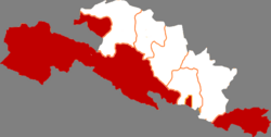 Sunan in Zhangye | |
 Zhangye in Gansu | |
| Coordinates: 38°50′19″N 99°37′07″E / 38.83861°N 99.61861°ECoordinates: 38°50′19″N 99°37′07″E / 38.83861°N 99.61861°E | |
| Country | People's Republic of China |
| Province | Gansu |
| Prefecture-level city | Zhangye |
| Area | |
| • Total | 23,800 km2 (9,200 sq mi) |
| Population (2018) | |
| • Total | 39,046[1] |
| Time zone | UTC+8 (China Standard) |
| Postal code | 734400 |

Sunan Yugur Autonomous County (simplified Chinese: 肃南裕固族自治县; traditional Chinese: 肅南裕固族自治縣; pinyin: Sùnán Yùgùzú Zìzhìxiàn) is an autonomous county under the administration of the prefecture-level city of Zhangye, Gansu Province, China, bordering Qinghai province to the south. It is home to the majority of the Yugur ethnic group. The seat of government is in Hongwansi Town (红湾寺镇).
The county has an area of 20,456 km2 (7,898 sq mi) and the population was 35,869 in 1999.[2]
Sùnán Yugur Autonomous County consists of three separate areas: Mínghua District, situated in the plains in the northwest, and Huángcheng District, situated in the mountains in the southeast, are separated from the main part of the county.
The county is home to a number of other ethnic groups, including Tibetans, who make up most of the population of .[3]
Administrative divisions[]
Sunan Yugur Autonomous County is divided to 3 towns, 2 townships, 3 ethnic townships and 2 others.[4]
- Towns
|
|
- Townships
- Dahe Township(大河乡)
- Minghua Township (明花乡)
- Ethnic townships
|
|
- Others
- Gansu Sheep Breeding Farm(甘肃省绵羊育种场)
- Zhangye Baopinghe Ranch (张掖宝瓶河牧场)
| Ethnic composition of Sùnán Yugur Autonomous County according to its Districts and Townships[5] | |||||||
|---|---|---|---|---|---|---|---|
| Towns and Townships | Total | Yugur | Han | Tibetan | Hui | Monguor | Mongol |
| total | 35500 | 8825 | 16976 | 8393 | 614 | 356 | 316 |
| Hongwansì Town | 5637 | 1193 | 3568 | 754 | 48 | 38 | 24 |
| Huangcheng Town | 7408 | 1486 | 3530 | 2037 | 193 | 145 | 12 |
| Beitan Township | 1504 | 456 | 818 | 168 | 49 | 2 | 11 |
| Dongtan Township | 2052 | 578 | 1333 | 36 | 100 | 4 | |
| Huajian Township | 1509 | 29 | 928 | 477 | 33 | 38 | |
| Mayíng Township | 650 | 419 | 215 | 16 | |||
| Yangxiang Township | 1693 | 4 | 236 | 1340 | 11 | 101 | 1 |
| Mati Town | 5265 | 43 | 2801 | 2343 | 28 | 35 | 15 |
| Daquangou Township | 1974 | 8 | 1442 | 524 | |||
| Dadouma Township | 2034 | 21 | 1142 | 815 | 8 | 35 | 13 |
| Xishui Township | 1257 | 14 | 217 | 1004 | 20 | 2 | |
| Kangle Town | 4466 | 1831 | 2057 | 196 | 170 | 63 | 257 |
| Baiyin Township | 831 | 28 | 556 | 29 | 9 | 218 | |
| Hongshiwo Township | 1655 | 1156 | 404 | 45 | 4 | 8 | 38 |
| Qinglong Township | 1456 | 267 | 889 | 98 | 146 | 55 | |
| Yangge Township | 524 | 380 | 108 | 24 | 11 | 1 | |
| Dahe Town | 5802 | 2131 | 3174 | 260 | 162 | 72 | 4 |
| Jiucaigou Township | 1729 | 1103 | 561 | 28 | 32 | 1 | 4 |
| Lamawan Township | 1149 | 74 | 1038 | 29 | 8 | ||
| Shuiguan Township | 618 | 336 | 170 | 111 | 1 | ||
| Xuequan Township | 2306 | 618 | 1404 | 121 | 100 | 63 | |
| Minghua Town | 2418 | 2088 | 307 | 19 | 1 | 2 | |
| Minghai Township | 1052 | 1002 | 47 | 1 | 1 | ||
| Lianhua Township | 890 | 779 | 93 | 17 | 1 | ||
| Qiantan Township | 476 | 307 | 167 | 1 | 1 | ||
| Qifeng District | 3408 | 50 | 558 | 2787 | 8 | 2 | 2 |
| Qílian Township | 1088 | 3 | 77 | 1007 | 1 | ||
| Qílin Township | 654 | 7 | 67 | 580 | |||
| Qíwen Township | 1181 | 40 | 374 | 760 | 4 | 1 | 2 |
| Qiqing Township | 485 | 40 | 440 | 4 | |||
| nomads | 1096 | 3 | 1082 | 6 | 5 | ||
References[]
- ^ "China : Population - ceicdata.com". ceicdata. Retrieved 2020-12-30.
- ^ National Population Statistics Materials by County and City - 1999 Period, in China County & City Population 1999, Harvard China Historical GIS
- ^ http://www-wds.worldbank.org/servlet/WDSContentServer/WDSP/IB/2005/04/13/000090341_20050413083243/Rendered/PDF/IPP1200EMDP0101August012020041.pdf
- ^ "统计用区划代码 www.stats.gov.cn" (in Chinese). XZQH. Retrieved 2020-12-27.
- ^ Data from Yáng 1993: 106; there are further a few individuals of other nationalities [1].
This Gansu location article is a stub. You can help Wikipedia by . |
- County-level divisions of Gansu
- Zhangye
- Autonomous counties of the People's Republic of China
- Gansu geography stubs