Xiahe County
Xiahe County
夏河县 | |
|---|---|
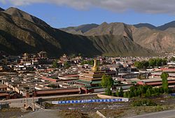 Labrang Monastery | |
 Xiahe County (red) within Gannan Prefecture (yellow) and Sichuan | |
| Coordinates (Xiahe County government): 35°12′09″N 102°31′18″E / 35.2025°N 102.5218°ECoordinates: 35°12′09″N 102°31′18″E / 35.2025°N 102.5218°E | |
| Country | People's Republic of China |
| Province | Gansu |
| Autonomous prefecture | Gannan |
| Area | |
| • Total | 6,274 km2 (2,422 sq mi) |
| Population (2017) | |
| • Total | 89,800 |
| • Density | 14/km2 (37/sq mi) |
| Time zone | UTC+8 (China Standard) |
| Postal code | 747100 |
| Website | www |

Xiahe (Chinese: 夏河; pinyin: Xiàhé; Tibetan: བསང་ཆུ་, Wylie: bsang chu, ZYPY: Sangqu) is a county in Gannan Tibetan Autonomous Prefecture, Gansu province, the People's Republic of China, bordering Qinghai province to the west. It is home to the famed Labrang Tibetan Buddhist monastery, one of the largest Tibetan Buddhist monasteries outside the Tibet Autonomous Region. The town is populated largely by ethnic Tibetans, as well as some Hui and Han Chinese. The area is highly rural and pastoral (including yak and other animal rearing). The geography is mountainous. In recent years it has become a tourist attraction. The county was named Xiahe in 1928, after the Daxia River that flows through its territory.


History[]
Xiahe (Sangqu) used to be part of Qinghai when it was under the control of Chinese Muslim General Ma Qi.[1] It was the site of bloody battles between Muslim and Tibetan forces.[2][3][4]
Location[]
Xiahe (Sangqu) is found in the southern portion of Gansu province, along the western border with Qinghai province. It lies along the Daxia and . It is on the northeast edge of the Tibetan Plateau. The average elevation is 2,900 to 3,100 metres (9,500 to 10,200 ft) with the highest being 4,636 metres (15,210 ft) and the lowest 2,160 metres (7,087 ft).
Climate[]
Xiahe County has an alpine subarctic climate (Köppen Dwc) that grades into an alpine climate (ETH) at the highest elevations. The climate is characterised by mild, rainy summers and frigid, but dry and sunny, winters.
| hideClimate data for Xiahe County | |||||||||||||
|---|---|---|---|---|---|---|---|---|---|---|---|---|---|
| Month | Jan | Feb | Mar | Apr | May | Jun | Jul | Aug | Sep | Oct | Nov | Dec | Year |
| Average high °C (°F) | 5 (41) |
7 (45) |
10 (50) |
13 (55) |
17 (63) |
21 (70) |
19 (66) |
17 (63) |
15 (59) |
9 (48) |
8 (46) |
5 (41) |
12 (54) |
| Average low °C (°F) | −18 (0) |
−16 (3) |
−12 (10) |
−8 (18) |
−6 (21) |
−2 (28) |
3 (37) |
1 (34) |
−3 (27) |
−7 (19) |
−12 (10) |
−16 (3) |
−8 (18) |
| Average precipitation mm (inches) | 6 (0.2) |
15 (0.6) |
14 (0.6) |
62 (2.4) |
101 (4.0) |
105 (4.1) |
174 (6.9) |
120 (4.7) |
139 (5.5) |
44 (1.7) |
9 (0.4) |
3 (0.1) |
792 (31.2) |
| Source: [5] | |||||||||||||
Name[]
The name (both Chinese and Tibetan), which literally means, "Xia River" refers to the Daxia River which runs through the county.
Administrative Divisions[]
Townships:
Other areas:
- Xiahe County Seed Station (夏河), Xiahe County Jisi General Station (夏河县机饲总站), Xiahe County Sangke Sheep Farm (夏河县桑科种羊场)
See also[]
References[]
- ^ Frederick Roelker Wulsin, Joseph Fletcher, Peabody Museum of Archaeology and Ethnology, National Geographic Society (U.S.), Peabody Museum of Salem (1979). Mary Ellen Alonso (ed.). China's inner Asian frontier: photographs of the Wulsin expedition to northwest China in 1923 : from the archives of the Peabody Museum, Harvard University, and the National Geographic Society (illustrated ed.). The Museum : distributed by Harvard University Press. p. 49. ISBN 0-674-11968-1. Retrieved 2010-06-28.CS1 maint: multiple names: authors list (link)
- ^ Dean King (2010). Unbound: A True Story of War, Love, and Survival (illustrated ed.). Hachette Digital, Inc. ISBN 978-0-316-16708-6. Retrieved 2010-06-28.
- ^ Paul Hattaway (2004). Peoples of the Buddhist world: a Christian prayer diary. William Carey Library. p. 4. ISBN 0-87808-361-8. Retrieved 2011-05-29.
- ^ Gary Geddes (2008). Kingdom of Ten Thousand Things: An Impossible Journey from Kabul to Chiapas (illustrated ed.). Sterling Publishing Company, Inc. p. 175. ISBN 978-1-4027-5344-2. Retrieved 2011-05-29.
- ^ "NASA Earth Observations Data Set Index". NASA. Retrieved 30 January 2016.
- ^ 2018年统计用区划代码和城乡划分代码:夏河县 [2018 Statistical Area Numbers and Rural-Urban Area Numbers: Xiahe County]. National Bureau of Statistics of the People's Republic of China. 2018. Retrieved 7 June 2019.
统计用区划代码 名称 623027100000 拉卜楞镇 623027101000 王格尔塘镇 623027102000 阿木去乎镇 623027103000 桑科镇 623027104000 甘加镇 623027105000 麻当镇 623027106000 博拉镇 623027107000 科才镇 623027202000 达麦乡 623027204000 曲奥乡 623027205000 唐尕昂乡 623027206000 扎油乡 623027208000 吉仓乡 623027400000 夏河县种子站 623027401000 夏河县机饲总站 623027402000 夏河县桑科种羊场
- ^ 夏河简介 (in Chinese). Xiahe County People's Government. 1 November 2016. Retrieved 6 July 2019.
2011年末辖拉卜楞、王格尔塘、阿木去乎3个镇,桑科、甘加、达麦、麻当、曲奥、唐尕昂、扎油、吉仓、博拉、科才10个乡,4个社区,共65个村委会、438个村民小组。
External links[]
| Wikivoyage has a travel guide for Xiahe. |
- People's Government of Xiahe Official Website Chinese version
- People's Government of Xiahe Official Website English version
- Journey through China - A site with numerous pictures of Xiahe.
- http://www.synaptic.bc.ca/gallery/xiahe.htm
This Gansu location article is a stub. You can help Wikipedia by . |
- Xiahe County
- County-level divisions of Gansu
- Gannan Tibetan Autonomous Prefecture
- Gansu geography stubs