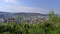
Wuwei, Gansu
Wuwei
武威市 | |
|---|---|
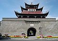
 South Gate of Wuwei | |
 Location of Wuwei City jurisdiction in Gansu | |
| Coordinates (Wuwei municipal government): 37°55′44″N 102°38′17″E / 37.929°N 102.638°ECoordinates: 37°55′44″N 102°38′17″E / 37.929°N 102.638°E | |
| Country | People's Republic of China |
| Province | Gansu |
| Municipal seat | Liangzhou District |
| Area | |
| • Total | 33,000 km2 (13,000 sq mi) |
| Population (2010) | |
| • Total | 1,815,054 |
| • Density | 55/km2 (140/sq mi) |
| Time zone | UTC+8 (China Standard) |
| ISO 3166 code | CN-GS-06 |
| Website | www |

Wuwei (Chinese: 武威; pinyin: Wŭwēi) is a prefecture-level city in northwest central Gansu province. In the north it borders Inner Mongolia, in the southwest, Qinghai. Its central location between three western capitals, Lanzhou, Xining, and Yinchuan makes it an important business and transportation hub for the area. Because of its position along the Hexi Corridor, historically the only route from central China to western China and the rest of Central Asia, many major railroads and national highways pass through Wuwei.
History[]


In ancient times, Wuwei was called Liangzhou (涼州—the name retained by today's Wuwei's central urban district) and is the eastern terminus of the Hexi Corridor. People began settling here about 5,000 years ago. It was a key link for the Northern Silk Road,[1] and a number of important archaeological finds were uncovered from Wuwei, including ancient copper carts with stone animals.[2] The motifs and types of objects in the Wuwei graves, as well as their earthenware, lacquer, and bronze composition, constitute typical examples of the Han Chinese burial style that can be found all over China. Other graves found along the Hexi Corridor show Xiongnu and other minority influence, which are used to trace regimes such as the Northern Liang.[3] It became an important provincial capital during the Former Han Dynasty as the Hou Hanshu makes clear:
"In the third year [170 CE], Meng Tuo, the Inspector of Liangzhou (modern Wuwei), sent the Assistant Officer Ren She, commanding five hundred soldiers from Dunhuang. He, with the Wuji Major Cao Kuan, and Chief Clerk of the Western Regions, Zhang Yan, brought troops from Yanqi (Karashahr), Qiuci (Kucha), and the Nearer and Further Kingdoms of Jushi (Turfan and Jimasa), altogether numbering more than 30,000, to punish Shule (Kashgar). They attacked the town of Zhenzhong (Arach) but, having stayed for more than forty days without being able to subdue it, they withdrew. Following this, the kings of Shule (Kashgar) killed one another repeatedly and, for its part, the Imperial Government was unable to prevent it."[4]
In 121 BC Han emperor Wudi brought his cavalry here to defend the Hexi Corridor against the Xiongnu Huns. His military success allowed him to expand the corridor westward. Its importance as a stop along the Silk Road made it a crossroads of cultures and ethnic groups from all over central Asia. Numerous Buddhist grottoes and temples in the area attest to its role as a path for bringing Buddhism from India and Afghanistan to China.
During the Three Kingdoms period (184-280), Liangzhou was governed by Qiang leader Ma Teng. After the death of Ma Teng, Ma Chao assumed the post and governed the province for a short time before it fell into the hands of Cao Cao, ruler of Wei Kingdom.
Liangzhou was briefly (from 400 to 421) a state during the Sixteen Kingdoms period.
Famous cultural relics from Wuwei include the Galloping Bronze Horse (铜奔马), Western Xia mausoleums(西夏碑), (白塔寺), (天梯山石窟), Luoshi(Kumārajīva) Temple (罗什寺塔), and the Confucian temple (文庙).
Geography, geology and climate[]
Wuwei's geography is dominated by three plateaus, the Loess, Tibetan, and Mongolian. Elevation can be generalized as, the south is higher than the north, with an elevation ranging from 1,020 to 4,874 metres (3,346 to 15,991 ft) above sea-level. Its area is 33,000 km2 (13,000 sq mi). Average annual temperature is 7.8 °C (46.0 °F). The climate is cold arid (Köppen BWk) with precipitation between 60 to 610 mm (2.4 to 24.0 in). Evaporation is from 1,400 to 3,000 mm (55 to 118 in), creating a net loss of water each year. There are 2200–3000 sunlight hours each year and from 85–165 frost free days. Summer temperatures can be in excess of 45.0 °C (113.0 °F), in the shade are by no means unheard of.
Southwest of Wuwei, there is a 230 metres (750 ft) thick Tianzhu Formation made of clastics intercalated with sandy shale and shale.[5] Minerals deposits occurring in the vicinity of Wuwei include graphite, iron, titanium, and limestone.
| hideClimate data for Wuwei (1971−2000) | |||||||||||||
|---|---|---|---|---|---|---|---|---|---|---|---|---|---|
| Month | Jan | Feb | Mar | Apr | May | Jun | Jul | Aug | Sep | Oct | Nov | Dec | Year |
| Record high °C (°F) | 15.4 (59.7) |
19.8 (67.6) |
23.7 (74.7) |
31.0 (87.8) |
34.2 (93.6) |
35.0 (95.0) |
40.8 (105.4) |
37.3 (99.1) |
34.9 (94.8) |
27.8 (82.0) |
22.6 (72.7) |
17.9 (64.2) |
40.8 (105.4) |
| Average high °C (°F) | 0.0 (32.0) |
3.3 (37.9) |
9.6 (49.3) |
17.8 (64.0) |
22.9 (73.2) |
26.5 (79.7) |
28.9 (84.0) |
27.6 (81.7) |
22.4 (72.3) |
15.9 (60.6) |
8.1 (46.6) |
1.9 (35.4) |
15.4 (59.7) |
| Daily mean °C (°F) | −7.8 (18.0) |
−4.2 (24.4) |
2.5 (36.5) |
10.4 (50.7) |
15.7 (60.3) |
19.3 (66.7) |
21.5 (70.7) |
20.4 (68.7) |
14.9 (58.8) |
7.8 (46.0) |
0.1 (32.2) |
−5.8 (21.6) |
7.9 (46.2) |
| Average low °C (°F) | −13.8 (7.2) |
−10.2 (13.6) |
−3.8 (25.2) |
3.0 (37.4) |
8.0 (46.4) |
11.6 (52.9) |
14.2 (57.6) |
13.7 (56.7) |
8.8 (47.8) |
1.6 (34.9) |
−5.6 (21.9) |
−11.3 (11.7) |
1.3 (34.4) |
| Record low °C (°F) | −24.0 (−11.2) |
−24.0 (−11.2) |
−18.1 (−0.6) |
−7.7 (18.1) |
−3.0 (26.6) |
2.8 (37.0) |
7.2 (45.0) |
4.3 (39.7) |
−0.8 (30.6) |
−14.4 (6.1) |
−22.7 (−8.9) |
−32.0 (−25.6) |
−32.0 (−25.6) |
| Average precipitation mm (inches) | 1.4 (0.06) |
2.3 (0.09) |
6.1 (0.24) |
7.9 (0.31) |
15.8 (0.62) |
28.4 (1.12) |
30.2 (1.19) |
34.0 (1.34) |
24.1 (0.95) |
10.8 (0.43) |
3.6 (0.14) |
1.2 (0.05) |
165.8 (6.54) |
| Average precipitation days (≥ 0.1 mm) | 2.1 | 2.6 | 3.6 | 4.1 | 5.9 | 8.2 | 9.6 | 9.8 | 7.7 | 4.4 | 1.6 | 1.8 | 61.4 |
| Source: Weather China | |||||||||||||
A species of stone loach, Triplophysa wuweiensis, is named after Wuwei where it was first discovered.[6]
Administration[]

1 urban district, 2 counties, 1 autonomous county, 116 towns, and 41 townships
| Map | ||||||
|---|---|---|---|---|---|---|
| Name | Hanzi | Hanyu Pinyin | Population (2010) |
Area (km²) |
Density (/km²) | |
| Liangzhou District | 凉州区 | Liángzhōu Qū | 1,010,295 | 5,081 | 207.29 | |
| Minqin County | 民勤县 | Mínqín Xiàn | 241,251 | 16,016 | 15.2 | |
| Gulang County | 古浪县 | Gǔlàng Xiàn | 388,720 | 5,287 | 78.13 | |
| Tianzhu Tibetan Autonomous County |
天祝藏族自治县 | Tiānzhù Zàngzú Zìzhìxiàn |
174,793 | 6,865 | 25.71 | |

Demographics[]
Population 1,815,054.[7] Urban: 509,600 with 38 ethnic groups represented including Han, Hui, Mongol, Tu, Tibetan, etc.
Economy[]
Consistent sunlight and fertile soil make agriculture one of Wuwei's biggest industries. Other important industries are textiles, metallurgy, and construction materials. Melons, vegetables, wine and livestock are all major agricultural products. Organic farming is a trend with more land being set aside for “green farming” each year. Land use can be broken down into the following:
- 790 square kilometres (310 sq mi) of water
- 34,800 square kilometres (13,400 sq mi) of forest
- 355,300 square kilometres (137,200 sq mi) of grassland.
- 247,000 square kilometres (95,000 sq mi) of “undeveloped” land.
- 39,100 square kilometres (15,100 sq mi) of farmland.
- 8,000 square kilometres (3,100 sq mi) of corn
- 4,000 square kilometres (1,500 sq mi) of vegetables
- 3,000 square kilometres (1,200 sq mi) of melons
- 5,000 square kilometres (1,900 sq mi) for livestock
- 800 square kilometres (310 sq mi) of vineyards
Transport[]
Wuwei is served by the G30 Lianyungang–Khorgas Expressway and China National Highway 312; the serves trains on the Lanzhou-Xinjiang Railway.
Footnotes[]
- ^ Silk Road, North China, C Michael Hogan, The Megalithic Portal, ed. A Burnham
- ^ Zhang Yiping (2005). Story of the Silk Road. China Intercontinental Press. ISBN 978-7-5085-0832-0.
- ^ Juhl, Susanne (1998). "Burial Sites in Hexi". In Atabaki, Touraj; O'Kane, John (eds.). Post-Soviet Central Asia. Tauris Academic Studies. pp. 370–371.
- ^ Hill (2015), p. 45.
- ^ Chih-i Chou, William Thornton Dean, Phanerozoic Geology of Northwest China, 1996, 316 pages ISBN 90-6764-228-2
- ^ Eschmeyer, W. N. and R. Fricke (eds) (3 December 2015). "Catalog of Fishes". California Academy of Sciences. Retrieved 20 December 2015.CS1 maint: extra text: authors list (link)
- ^ Main data bulletin of the sixth national census in 2010, 2011-05-09(in Chinese)
References[]
- Hill, John E. (2015) Through the Jade Gate to Rome - China to Rome. CreateSpace, Charleston, South Carolina. ISBN 978-1500696702.
External links[]
| Wikimedia Commons has media related to Wuwei. |

| Authority control |
|---|
- Wuwei, Gansu
- Prefecture-level divisions of Gansu
- Populated places along the Silk Road