Anning District
Anning
安宁区 | |
|---|---|
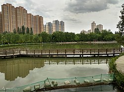 Anning District from the Lanzhou Botanical Garden | |
 Location in Lanzhou | |
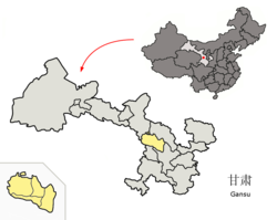 Lanzhou in Gansu | |
| Coordinates: 36°06′17″N 103°43′09″E / 36.1046°N 103.7191°ECoordinates: 36°06′17″N 103°43′09″E / 36.1046°N 103.7191°E | |
| Country | People's Republic of China |
| Province | Gansu |
| Prefecture-level city | Lanzhou |
| Area | |
| • Total | 82.33 km2 (31.79 sq mi) |
| Population (2014 Census) | |
| • Total | 187,189 |
| • Density | 2,300/km2 (5,900/sq mi) |
| Time zone | UTC+8 (China Standard) |
| Postal code | 730070 |
| Website | www |

Anning District (simplified Chinese: 安宁区; traditional Chinese: 安寧區; pinyin: Ānníng Qū) is one of 5 districts of the prefecture-level city of Lanzhou, the capital of Gansu Province, Northwest China. It forms part of the urban core of Lanzhou. The district was established in 1953 and is named after a former Ming dynasty fort.[1] It is known for having numerous peach orchards, since the Ming dynasty it has thus been nicknamed the '10-li peach county' (十里桃乡).[2]
Administrative divisions[]
Anning District is divided to 8 subdistricts.[3]
- Subdistricts
|
|
Education[]
The district is the home of several educational institutes:[1]
- Northwest Normal University
- Lanzhou Jiaotong University
- Gansu Agricultural University
- Gansu College of Political Science and Law
- Lanzhou City College
- Gansu Provincial Party School
- Gansu Academy of Agricultural Sciences
- Gansu Academy of Social Sciences
The Lanzhou Botanical Garden is also located in the district.
References[]
- ^ Jump up to: a b http://www.lzanning.gov.cn/art/2018/7/10/art_12002_653438.html
- ^ 《走近兰州》委会 (1 June 2010). 走进兰州. Beijing Book Co. Inc. p. 189. ISBN 978-7-226-03797-3.
- ^ "统计用区划代码 www.stats.gov.cn" (in Chinese). XZQH. Retrieved 2020-12-27.
See also[]
| show Authority control |
|---|
This Gansu location article is a stub. You can help Wikipedia by . |
Categories:
- County-level divisions of Gansu
- Gansu geography stubs