Tianshui
Tianshui
天水市 | |
|---|---|
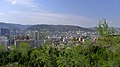
  Tianshui Fuyi pedestrian street (top), Tianshui skyline | |
 Location of Tianshui City jurisdiction in Gansu | |
| Coordinates (Tianshui municipal government): 34°34′53″N 105°43′29″E / 34.5815°N 105.7248°ECoordinates: 34°34′53″N 105°43′29″E / 34.5815°N 105.7248°E | |
| Country | People's Republic of China |
| Province | Gansu |
| Municipal seat | Qinzhou District |
| Area | |
| • Prefecture-level city | 14,280 km2 (5,510 sq mi) |
| • Urban | 5,866 km2 (2,265 sq mi) |
| • Metro | 5,866 km2 (2,265 sq mi) |
| Elevation | 1,171 m (3,842 ft) |
| Population | |
| • Prefecture-level city | 2,984,659 |
| • Density | 210/km2 (540/sq mi) |
| • Urban | 1,212,791 |
| • Urban density | 210/km2 (540/sq mi) |
| • Metro | 1,212,791 |
| • Metro density | 210/km2 (540/sq mi) |
| Time zone | UTC+8 (China Standard) |
| Postal code | 741000 |
| Area code(s) | 0938 |
| ISO 3166 code | CN-GS-05 |
| Licence plate prefixes | 甘E |
| Website | tianshui |

| Tianshui | |||
|---|---|---|---|
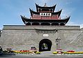
 The entrance to the in Tianshui | |||
| Chinese | 天水市 | ||
| Literal meaning | City of Sky and Water | ||
| |||
| Qinzhou | |||
| Chinese | 秦州 | ||
| Postal | Tsinchow | ||
| Literal meaning | Qin Province | ||
| |||
| Tianshui Commandery | |||
| Chinese | 天水郡 | ||
| Literal meaning | Commandery of Heaven and Water | ||
| |||
| Hanyang Commandery | |||
| Simplified Chinese | 汉阳郡 | ||
| Traditional Chinese | 漢陽郡 | ||
| |||
| Hanyang County | |||
| Simplified Chinese | 汉阳县 | ||
| Traditional Chinese | 漢陽縣 | ||
| |||
Tianshui is the second-largest city in Gansu Province, China. The city is located in the southeast of the province, along the upper reaches of the Wei River and at the boundary of the Loess Plateau and the Qinling Mountains. As of the 2020 census, its population was 2,984,659 inhabitants, of which 1,212,791 lived in the built-up (or metro) area made of the 2 urban districts of Qinzhou and Maiji.[3] The city and its surroundings have played an important role in the early history of China, as still visible in the form of historic sites such as the Maijishan Grottoes.
History[]
Qin, whose House of Ying were the founding dynasty of the Chinese empire, developed from Quanqiu (present-day Lixian) to the south. After the invasions of the Rong which unseated the Western Zhou, Qin recovered the territory of Tianshui from the nomads. It became an important region of their duchy and, later, kingdom.[4] Characteristically Qin tombs have been excavated at Fangmatan nearby, including one 2200-year-old map of Qin's .[5]
Under the Qin Empire, the area was part of Longxi Commandery but the Emperor Wu of the Han separated the region as the Tianshui Commandery in 114 BC as part of his expansion towards the Tarim Basin.[6] The general Li Guang came from the city. The Han conquests and explorations eventually resulted in the development of the Northern Silk Road: Tianshui formed its junction with the Wei River, after which it followed the road past to Chang'an (present-day Xi'an).[7] Nearby are the Maijishan Grottoes, filled with thousands of Buddhist sculptures representing figures such as Buddha and the original male form of Guanyin, produced between the Wei and Song dynasties by monks travelling along the road and by local Buddhists.[8]
During the Northern Wei, the city was known as Hanyang and was the center of the Hanyang Commandery. During the Western Wei, this name was changed to Hanyang County. During the Tang and Five Dynasties, the city of Tianshui was known as Shanggui (上邽). It alternated with Chengji (present-day Qin'an) as the capital of the province of Qinzhou (秦州).[9] Li County was separated from Tianshui's jurisdiction during the ninth year of Chenghua (AD 1473) during the Ming dynasty.
According to a legend, the name Tianshui (天水) originates from a lake formed from heaven, which would remain the same size year round.[6]
Subdivisions[]
| Map | ||||||
|---|---|---|---|---|---|---|
| Name | Hanzi | Hanyu Pinyin | Population (2004 est.) |
Area (km2) | Density (/km2) | |
| Qinzhou District | 秦州区 | Qínzhōu Qū | 650,000 | 2,442 | 266 | |
| Maiji District | 麦积区 | Màijī Qū | 580,000 | 3,452 | 188 | |
| Qingshui County | 清水县 | Qīngshuǐ Xiàn | 310,000 | 2,003 | 155 | |
| Qin'an County | 秦安县 | Qín'ān Xiàn | 600,000 | 1,601 | 375 | |
| Gangu County | 甘谷县 | Gāngǔ Xiàn | 600,000 | 1,572 | 382 | |
| Wushan County | 武山县 | Wǔshān Xiàn | 440,000 | 2,011 | 219 | |
| Zhangjiachuan Hui Autonomous County |
张家川回族自治县 | Zhāngjiāchuān Huízú Zìzhìxiàn |
320,000 | 1,311 | 244 | |

Geography[]
Tianshui is located in the valley of the Jie River, a major tributary of the Wei River, and on the boundary between the Loess Plateau and Qinling Mountains.[10][6] The city has a monsoon-influenced, cool semi-arid climate (Köppen BSk), with four distinct seasons of comparatively equal length. Winters are cold but dry, with January 24-hour average temperature of −1.5 °C (29.3 °F), while summers are warm and somewhat humid, with July 24-hour average temperature of 23.2 °C (73.8 °F). Much of the annual rainfall occurs from June to September, and the annual mean temperature is 11.44 °C (52.6 °F). With monthly percent possible sunshine ranging from 34% in September to 50% in December, the city receives 1,911 hours of bright sunshine annually.
| hideClimate data for Tianshui (1981−2010 normals) | |||||||||||||
|---|---|---|---|---|---|---|---|---|---|---|---|---|---|
| Month | Jan | Feb | Mar | Apr | May | Jun | Jul | Aug | Sep | Oct | Nov | Dec | Year |
| Record high °C (°F) | 12.1 (53.8) |
20.2 (68.4) |
27.0 (80.6) |
31.8 (89.2) |
33.9 (93.0) |
37.2 (99.0) |
38.2 (100.8) |
36.1 (97.0) |
36.2 (97.2) |
28.5 (83.3) |
21.6 (70.9) |
14.7 (58.5) |
38.2 (100.8) |
| Average high °C (°F) | 3.9 (39.0) |
7.5 (45.5) |
13.0 (55.4) |
19.7 (67.5) |
24.3 (75.7) |
27.5 (81.5) |
29.3 (84.7) |
27.9 (82.2) |
22.6 (72.7) |
16.8 (62.2) |
10.9 (51.6) |
5.2 (41.4) |
17.4 (63.3) |
| Daily mean °C (°F) | −1.5 (29.3) |
1.9 (35.4) |
6.9 (44.4) |
13.0 (55.4) |
17.5 (63.5) |
21.1 (70.0) |
23.2 (73.8) |
22.0 (71.6) |
17.2 (63.0) |
11.3 (52.3) |
5.1 (41.2) |
−0.4 (31.3) |
11.4 (52.6) |
| Average low °C (°F) | −5.4 (22.3) |
−2.2 (28.0) |
2.2 (36.0) |
7.4 (45.3) |
11.8 (53.2) |
15.6 (60.1) |
18.2 (64.8) |
17.4 (63.3) |
13.3 (55.9) |
7.5 (45.5) |
1.0 (33.8) |
−4.3 (24.3) |
6.9 (44.4) |
| Record low °C (°F) | −19.2 (−2.6) |
−16.6 (2.1) |
−10.0 (14.0) |
−6.4 (20.5) |
1.8 (35.2) |
5.5 (41.9) |
10.6 (51.1) |
8.4 (47.1) |
1.2 (34.2) |
−5.1 (22.8) |
−11.6 (11.1) |
−17.4 (0.7) |
−19.2 (−2.6) |
| Average precipitation mm (inches) | 4.9 (0.19) |
6.8 (0.27) |
17.8 (0.70) |
34.9 (1.37) |
53.1 (2.09) |
71.4 (2.81) |
87.2 (3.43) |
86.9 (3.42) |
76.9 (3.03) |
46.5 (1.83) |
10.7 (0.42) |
3.7 (0.15) |
500.8 (19.71) |
| Average precipitation days (≥ 0.1 mm) | 5.0 | 5.2 | 7.9 | 8.9 | 10.5 | 11.2 | 11.8 | 10.7 | 11.2 | 10.6 | 5.4 | 3.0 | 101.4 |
| Average relative humidity (%) | 61 | 60 | 59 | 57 | 60 | 64 | 68 | 71 | 76 | 76 | 70 | 64 | 66 |
| Mean monthly sunshine hours | 144.3 | 128.4 | 142.2 | 182.0 | 201.7 | 190.0 | 195.7 | 193.4 | 125.4 | 123.7 | 133.4 | 151.0 | 1,911.2 |
| Percent possible sunshine | 46 | 42 | 39 | 47 | 47 | 44 | 45 | 47 | 34 | 35 | 43 | 50 | 43 |
| Source: China Meteorological Administration (precipitation days and sunshine 1971–2000)[11][12] | |||||||||||||
Economy[]
Due to the mild climate, Tianshui is a large producer of fruits, in particular apples.[13]
It is also a major industrial centre in Gansu province, especially regarding electronics.[13] Some major industries include:
- AVIC Tianshui Aviation Industry[14]
- Tianshui Pneumatic Machinery Corporation[15]
- Tianshui Tractor Factory
- Spark Machine Tools[16]
Transportation[]
Airlines[]
Tianshui Maijishan Airport is located near the built up area.
Railway[]

Tianshui is currently serviced by Tianshui railway station on the Longhai Railway. The railway station is connected to downtown by the Tianshui Tram.
A new high-speed railway station, Tianshui South railway station, opened in 2017.
The Tianshui–Longnan railway is currently under construction and will add a north–south link to the county.
Highways[]
The Lianyungang–Khorgas Expressway connects Tianshui to Baoji/Xi'an in the east and Dingxi, Lanzhou towards the northwest and supersedes highway G310. G310 runs as a motorway within the urban centre.
- G7011 Shiyan–Tianshui Expressway
- G8513 Pingliang–Mianyang Expressway (section from Tianshui north to Pingliang is under construction)
- China National Highway 310
Culture[]
Tianshui's signature dish is Guagua (呱呱), a sticky boiled buckwheat flour meal, seasoned with chili oil, sesame paste , mustard , oil, salt, vinegar and garlic paste.[17] The dish is normally eaten as a breakfast.[18] According to legends it was the imperial food during Han dynasty general Wei Xiao's rule.[19]
Tourism[]
Education[]
- Gansu Electric Science Research Institute[20]
See also[]
References[]
- ^ https://www.citypopulation.de/en/china/gansu/admin/
- ^ "2021年天水市人口总人数口和第七次人口普查结果-红黑人口库2021年". www.hongheiku.com. Retrieved 2021-06-09.
- ^ https://www.citypopulation.de/en/china/gansu/admin/
- ^ People's Daily Online. "Chinese surname history: Qin".
- ^ Xinhua Online. "Over 2,200-Year-old Map Discovered in NW China Archived 2007-03-12 at the Wayback Machine".
- ^ Jump up to: a b c 甘肃大辞典 (in Chinese). 甘肃文化出版社. 2000. ISBN 978-7-80608-547-9.
- ^ Hogan, C. Michael. The Megalithic Portal. "Silk Road, North China".
- ^ Shrotriya, Alok & al. "Artistic treasures of Maiji Mountain caves".
- ^ Dudbridge, Glen. A Portrait of Five Dynasties China: From the Memoirs of Wang Renyu (880–956), pp. 8 ff. Oxford University Press (Oxford), 2013. Accessed 14 Dec 2013.
- ^ Peng, Jianbing; Leng, Yanqiu; Zhu, Xinghua; Wu, Di; Tong, Xiao (April 2016). "Development of a loess-mudstone landslide in a fault fracture zone". Environmental Earth Sciences. 75 (8): 658. doi:10.1007/s12665-016-5336-8. ISSN 1866-6280. S2CID 131398510.
- ^ 中国气象数据网 - WeatherBk Data (in Chinese). China Meteorological Administration. Retrieved 2020-04-15.
- ^ 中国地面国际交换站气候标准值月值数据集(1971-2000年). China Meteorological Administration. Archived from the original on 2013-09-21. Retrieved 2010-05-25.
- ^ Jump up to: a b "天水市旅游详细介绍,行政区划、人口面积、交通地图、特产小吃、风景图片、名胜古迹、景区景点等". www.365135.com. Retrieved 2021-01-26.
- ^ http://www.tsplane.com/
- ^ http://www.tsfd.com.cn/
- ^ "Spark machine tool homepage". www.sparkcnc.com. Retrieved 9 April 2018.
- ^ sina_mobile (2020-05-17). "天水 天水美食呱呱". k.sina.cn. Retrieved 2021-01-26.
- ^ "走近你不知道的甘肃舌尖上的非遗美食:天水呱呱!你吃过吗?". 16 June 2020.
- ^ "這樣的天水小吃你吃過嗎?呱呱" (in Chinese). Retrieved 2021-01-26.
- ^ 甘肃电器科学研究院. www.tsccs.com.cn. Retrieved 9 April 2018.
External links[]
| Wikimedia Commons has media related to Tianshui. |


| show Authority control |
|---|
- Tianshui
- Prefecture-level divisions of Gansu
- Cities in Gansu