Maqu County
Maqu County
རྨ་ཆུ་རྫོང་།· 玛曲县 | |
|---|---|
 | |
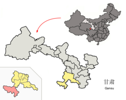 Maqu County (red) within Gannan Prefecture (yellow) and Gansu | |
| Coordinates (Maqu government): 33°59′52″N 102°04′22″E / 33.9977°N 102.0727°ECoordinates: 33°59′52″N 102°04′22″E / 33.9977°N 102.0727°E | |
| Country | People's Republic of China |
| Province | Gansu |
| Autonomous prefecture | Gannan |
| Area | |
| • Total | 10,190 km2 (3,930 sq mi) |
| Population (2017) | |
| • Total | 57,900 |
| • Density | 5.7/km2 (15/sq mi) |
| Time zone | UTC+8 (China Standard) |
| Postal code | 747300 |

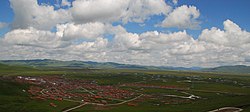
Maqu County (simplified Chinese: 玛曲县; traditional Chinese: 瑪曲縣; pinyin: Mǎqū Xiàn; Tibetan: རྨ་ཆུ་རྫོང་།, Wylie: Rma chu rdzong, ZYPY: Maqu Zong) is a county of the Gannan Tibetan Autonomous Prefecture in the south of Gansu province of the People's Republic of China, bordering the provinces of Sichuan to the east and southeast, and Qinghai to the southwest, west and northwest. Its postal code is 747300, and in 1999 its population was 36,213 people.[1] The area of Maqu County is 10,191 km2 with an average altitude of 3,700 meters.[2] Maqu County receives high rainfall and is located at the northern edge of the Zoigê Marshes on the Yellow River where conditions are optimal for alpine meadow vegetation.[2]
Administrative divisions[]
Maqu County (玛曲县) is divided to 6 towns and 2 townships.[3]
- Towns
|
|
- Townships
- Oulaxiuma Township (欧拉秀玛乡)
- Muxihe Township (木西合乡)
See also[]
References[]
- ^ "HGIS - Downloads". Archived from the original on 2008-08-28. Retrieved 2008-10-12.
- ^ a b "http://www.ifad.org/lrkm/region/pi/ICIMOD/cn_gansu.htm". Archived from the original on 2007-08-18. Retrieved 2012-12-04.
{{cite web}}: External link in|title= - ^ "统计用区划代码 www.stats.gov.cn" (in Chinese). XZQH. Retrieved 2012-05-26.
This Gansu location article is a stub. You can help Wikipedia by . |
- County-level divisions of Gansu
- Gannan Tibetan Autonomous Prefecture
- Gansu geography stubs