Yinchuan
Yinchuan
银川市 · ءٍچُوًا شِ Yinchwan | |
|---|---|
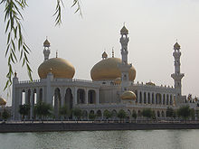
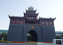
 Clockwise from top: View of Xingqing District from the Pagoda of Chengtian Temple, Drum Tower, Yinchuan railway station, Nanguan Grand Mosque, Western Xia mausoleums, Pagoda of Chengtian Temple, Fenghuang Monument | |
 | |
 The territory of Yinchuan prefecture-level city (yellow) within Ningxia | |
 Yinchuan Location of the city center in Ningxia | |
| Coordinates (Ningxia People's Government): 38°28′19″N 106°15′32″E / 38.472°N 106.2589°ECoordinates: 38°28′19″N 106°15′32″E / 38.472°N 106.2589°E | |
| Country | China |
| Autonomous region | Ningxia |
| Municipal seat | Jinfeng District |
| Government | |
| • Type | Prefecture-level city |
| • Body | |
| • CCP Secretary | Zhang Zhu |
| • Chairman | Li Hongru |
| • Mayor | Zhao Xuhui |
| • CPPCC Chairman | Ma Kai |
| Area | |
| • Prefecture-level city | 8,874.61 km2 (3,426.51 sq mi) |
| • Urban (2018)[1] | 492 km2 (190 sq mi) |
| • Metro | 2,045 km2 (790 sq mi) |
| Elevation | 1,100 m (3,608 ft) |
| Population (2019)[2] | |
| • Prefecture-level city | 2,293,085 |
| • Urban (2018)[3] | 2,570,000 |
| • Urban density | 5,200/km2 (14,000/sq mi) |
| • Metro | 1,487,561 |
| • Metro density | 730/km2 (1,900/sq mi) |
| Time zone | UTC+8 (China Standard) |
| Postal code | 750000 |
| Area code(s) | 0951 |
| ISO 3166 code | CN-NX-01 |
| License plate prefixes | 宁A |
| Website | www.yinchuan.gov.cn (Chinese) |


| Yinchuan | |||
|---|---|---|---|
 "Yínchuān" in Simplified (top) and Traditional (bottom) Chinese characters | |||
| Simplified Chinese | 银川 | ||
| Traditional Chinese | 銀川 | ||
| Hanyu Pinyin | Yínchuān | ||
| Literal meaning | "Silver River" | ||
| |||
Yinchuan (UK: /jɪnˈtʃwæn/, US: /-tʃwɑːn/;[4] simplified Chinese: 银川; traditional Chinese: 銀川; pinyin: Yínchuān) is the capital of the Ningxia Hui Autonomous Region, China,[5] and was capital of the Western Xia Empire of the Tanguts. It has an area of 8,874.61 km2 (3,426.51 sq mi) and a total population of 2.29 million.[2] Its built-up area is home to 1,487,561 inhabitants spread between three urban districts.[2] The city's name literally means "silver river".
Facing the Yellow River in the east, Yinchuan is known as a "River Side City in the Northwest" and "Home to Fish and Rice". Yinchuan is now the permanent site for the China-Arab Expo, a platform for cultural and economic exchanges between China and Arab countries.
The city is also home to Ningxia University, the largest regional comprehensive university under the Project 211 in Ningxia Hui Autonomous Region.
History[]

Yinchuan was originally a county under the name of Fuping in the 1st century BCE; its name was changed to Huaiyuan in the 6th century CE.
Western Xia[]
After the fall of the Tang dynasty in 907, it was occupied by the Tangut Western Xia Empire and was made the capital of the empire, provoking the entire native Chinese population to emigrate.[6]
Mongol conquest[]
After conquering the Western Xia in 1227, the Mongols mercilessly pillaged Yinchuan and slaughtered its entire population.[7][8] The Mongols called the city Iryai.
Ming and Qing dynasties[]
Under the Ming (1368–1644) and Qing (1644–1911) dynasties, it was a prefecture of Ningxia. During the Dungan revolt, Dungan forces massacred 100,000 people in Yinchuan.
20th century[]
In 1928, when the province of Ningxia was formed from part of Gansu, it became the capital city. In 1954, when Ningxia province was abolished, the city was put in Gansu province; but, with the establishment of the Ningxia Hui autonomous region in 1958, Yinchuan once again became the capital.
Traditionally, Yinchuan was an administrative and commercial center. In the 1950s it had many commercial enterprises, and there were some handicrafts but no modern industry. The city has since grown considerably. Extensive coal deposits discovered on the eastern bank of the Yellow River, near Shizuishan, 100 km (62 mi) to the north, have made Shizuishan a coal-mining center.
Yinchuan, however, remains largely non-industrial. The immediate plains area, intensively irrigated by a system developed as long ago as the Han (206 BC–AD 220) and Tang (618–907) dynasties, is extremely productive. Yinchuan is the chief agricultural market and distribution center for this area and also deals in animal products from the herds tended by nomads in the surrounding grasslands. It is a market for grain and has flour mills, as well as rice-hulling and oil-extraction plants. The wool produced in the surrounding plains supplies a woolen-textile mill.
Geography[]

Yinchuan lies in the middle of the Yinchuan or . It is sheltered from the deserts of Mongolia by the high ranges of the Helan Mountains to its west. The Yellow River runs through Yinchuan from southwest to northeast. The average elevation of Yinchuan is 1,100 meters (about 3,608 feet). The urban center of Yinchuan lies about halfway between the Yellow River and the edge of Helan Mountains.
Climate[]
Yinchuan has a cold desert climate (Köppen BWk) with an annual rainfall of 186 mm (7.32 in). Yinchuan has distinct seasons, with dry, cold winters, late springs and short summers. The monthly 24-hour average temperature ranges from −7.9 °C (17.8 °F) in January to 23.5 °C (74.3 °F) in July, with the annual mean at 9.00 °C (48.2 °F). Diurnal temperature variation tends to be large due to the aridity, which also partly contributes to the sunny climate; with monthly percent possible sunshine ranging from 63 percent in three months to 71 percent in November, the city receives 2,906 hours of bright sunshine annually. There are 158 frost-free days.
| showClimate data for Yinchuan (1971–2000) |
|---|
Administrative divisions[]
| Map | ||||||
|---|---|---|---|---|---|---|
| Name | Simplified Chinese | Hanyu Pinyin | Xiao'erjing | Population (2019)[2] |
Area (km2) | Density (/km2) |
| City proper | ||||||
| Xingqing District | 兴庆区 | Xīngqìng Qū | ثٍْٿٍْ ٿِيُوِ | 755,441 | 768 | 984 |
| Jinfeng District | 金凤区 | Jīnfèng Qū | ڭٍفٍْ ٿِيُوِ | 369,296 | 290 | 1,273 |
| Xixia District | 西夏区 | Xīxià Qū | ثِثِيَا ٿِيُوِ | 362,842 | 987 | 368 |
| Satellite cities | ||||||
| Lingwu City | 灵武市 | Língwǔ Shì | لِئٍوُ شِ | 296,122 | 4,639 | 64 |
| Rural | ||||||
| Yongning County | 永宁县 | Yǒngníng Xiàn | يٌنِئٍ ثِيًا | 245,570 | 1,295 | 190 |
| Helan County | 贺兰县 | Hèlán Xiàn | حَلًا ثِيًا | 263,832 | 1,600 | 165 |

Demographics[]
Ethnic groups[]
As of 2019, 72.43% of the city's population is Han Chinese, 25.79% is Hui, and 1.78% are other ethnic minorities.[2] Of the city's six county-level divisions, all have a super-majority of Han Chinese people sans the county-level city of Lingwu, which is majority Hui.[2]
Urbanization[]
Of the city's population, 79.05% live in urban areas as of 2019.[2] This proportion is highest in Xixia District, where 91.28% of the population lives in urban areas, and is lowest in Lingwu, where 58.22% of the population lives in urban areas.[2]
Economy[]
The city's gross domestic product per capita was ¥31,436 (US$4,526) in 2008, ranking 197th of 659 Chinese cities. In 2010, Yinchuan was designated as the site for the China-Arab States Cooperation Forum. At the national level, Yinchuan hosts various events such as the China-Arab States Expo, to function as a commercial link between China and Arab States.
Yinchuan classifies itself as a 'smart city', where modern technology is employed such as facial recognition for public transport payments, connected trash bins and digital citizen service centres.[10][11][12][13]
Transportation[]

- It is served by Yinchuan Hedong International Airport. It is 25 km (16 mi) from Yinchuan and has flights to Beijing, Chengdu, Dunhuang, Guangzhou, Shanghai, Xian, and Zhengzhou.
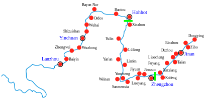
- It is served by a river port at , about 15 km (9.3 mi) to the east. Until the 1950s the river, which is navigable downstream as far as Baotou in the Inner Mongolian autonomous region and upstream to Zhongwei and Zhongning, was the chief communication link.
- Highways also link the city to Baotou along the river, to Lanzhou in Gansu province to the southwest, to Wuwei in Gansu to the west, and to Xi'an in Shaanxi province to the southeast.
- Since 1958 the city has been served by Yinchuan railway station on the Baotou–Lanzhou railway and is thus linked to other parts of China by rail. The Taiyuan–Zhongwei–Yinchuan railway opened in 2011.
- China National Highway 211
- G69 Yinchuan–Baise Expressway
- Yinchuan is the first Chinese city to implement a monorail beyond demonstrational use, transporting visitors around the Yinchuan International Flower Expo park.
Culture[]
Although most residents are Han Chinese, Yinchuan is a center for the Muslim Hui people, who constitute slightly over a quarter of the population.[2]
Tourism[]
This section does not cite any sources. (August 2020) |

The city's attractions include the Sand-lake, the Western Xia tombs, and the China Western film Studios.
Sand Lake is a lake in a desert 35 miles north of Yinchuan with birds, reeds, lotus and fish.
The Western Xia Imperial Tombs are 15.5 miles west of Yinchuan on east side of Mt. Helan. Since June 1972, nine imperial tombs and 253 lesser tombs have been unearthed, which are as grand as Ming Tombs in Beijing. With a total area of more than 19.3 square miles, it is unique among royal burials.
China West Film Studio, which has been famed as 'One Superb in China, and Treasure of Ningxia Province', is at the eastern foot of the magnificent Helanshan Mountain, 25 kilometers from the railway station of Yinchuan City, and 48 kilometers from Hedong Airport. It produced The Herdsman, Red Sorghum, Lover's Grief over the Yellow River, New Dragon Gate Inn, Ashes of Time, A Chinese Odyssey, Qiao's Grand Courtyard (TV series) and nearly one hundred other films.
There are two pagodas in Yinchuan that are part of the 'Eight Famous Scenery of Ningxia': one is the Haibao Pagoda in the northern suburb and the other is the Chengtiansi Pagoda in the west.
Parts of the Great Wall are near the city.
Since 2000, Yinchuan has hosted the annual Yinchuan International Car and Motorcycle Tourism Festival, which usually occurs in August.
Colleges and universities[]
- Ningxia University
- Ningxia Medical University
See also[]
- List of twin towns and sister cities in China
References[]
- ^ Cox, W (2018). Demographia World Urban Areas. 14th Annual Edition (PDF). St. Louis: Demographia. p. 22.
- ^ Jump up to: a b c d e f g h i 2019年末银川市常住人口229.31万人 (in Chinese). Yinchuan City Statistics Bureau. 27 February 2020. Archived from the original on 17 August 2020. Retrieved 17 August 2020.
- ^ Cox, W (2018). Demographia World Urban Areas. 14th Annual Edition (PDF). St. Louis: Demographia. p. 22.
- ^ "Yinchuan". Lexico UK Dictionary. Oxford University Press.
- ^ "Illuminating China's Provinces, Municipalities and Autonomous Regions". PRC Central Government Official Website. Retrieved 17 May 2014.
- ^ Jack Weatherford Genghis Khan and the Making of the Modern World, p.85
- ^ Mote, Frederick W. (1999). Imperial China: 900-1800. Cambridge, Massachusetts: Harvard University Press. p. 256. ISBN 0674012127.
- ^ Boland-Crewe, Tara; Lea, David, eds. (2002). The Territories of the People's Republic of China. London: Europa Publications. p. 215. ISBN 9780203403112.
- ^ 中国地面国际交换站气候标准值月值数据集(1971-2000年) (in Chinese). China Meteorological Administration. Archived from the original on 21 September 2013. Retrieved 4 May 2010.
- ^ Dahad, Nitin (9 October 2016). "Yinchuan: China's leading smart city shows how government and technology can help improve the life of its citizens".
- ^ "ZTE Partners with TM Forum and City of Yinchuan on Smart City Innovation Center".
- ^ Guerrini, Federico. "Cities Cannot Be Reduced To Just Big Data And IoT: Smart City Lessons From Yinchuan, China".
- ^ Carrington, Daisy. "In Yinchuan, China, your face is your credit card". CNN.
External links[]
| Wikimedia Commons has media related to Yinchuan. |
| Look up Yinchuan or Yin-ch'uan in Wiktionary, the free dictionary. |
| Wikivoyage has a travel guide for Yinchuan. |
- Yinchuan Government website
- Weather forecast for Yinchuan in Ningxia (China), 1117 m
- The Yinchuan World Rock Art Museum
- China West Film Studio
- Website specifically about Yinchuan in English
| show Ningxia topics |
|---|
| show Major cities along the Yellow River |
|---|
| show Authority control |
|---|
- Yinchuan
- Prefecture-level divisions of Ningxia
- Provincial capitals in China