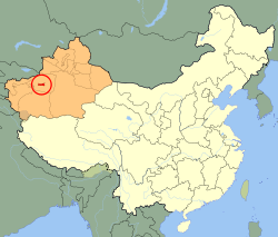
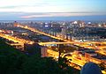
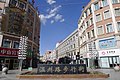
Aral[1][2] is a sub-prefecture-level city surrounded by Aksu Prefecture in Xinjiang Uyghur Autonomous Region, China. Aral means "island" in Uyghur.[3] The city's name is also often written as Alar.[4]
According to Radio Free Asia, a United States government-funded news service, Aral was created in the 1950s by the Xinjiang Production and Construction Corps to facilitate Han Chinese immigration to the region.[5]
Aral became a city in 2002 and its population increased to 166,205 in 2010.
On January 23, 2013, 474.208 km2 (183.093 sq mi) of territory was transferred from Awat County (Awati) to Aral city[6] and 802.733 km2 (309.937 sq mi) of territory was transferred from Aksu city (Akesu) to Aral city.[7]
Geography[]
The city has an administrative area of 5,258.739 km2 (2,030.410 sq mi). It is bordered by mountainous regions to the north and northwest and the Taklamakan Desert to the east and south.
Demographics[]
As of 2015, 167,697 (93.6%) of the 179,214 residents of the county were Han Chinese, 6,036 (3.4%) were Uyghur and 5,481 were from other ethnic groups.[8]
Education[]
Tarim University is located in Aral.
See also[]
Xinjiang Production and Construction Corps
References[]
^The official spelling according to Zhōngguó dìmínglù, 中国地名录 (Beijing, SinoMaps Press中国地图出版社 1997); ISBN7-5031-1718-4
^The official spelling is Aral, according to the Zhōngguó dìmínglù, 中国地名录 (Beijing, SinoMaps Press 1997); ISBN7-5031-1718-4; p. 1, 299.
^"Archived copy". Archived from the original on 2015-10-18. Retrieved 2014-05-03.{{cite web}}: CS1 maint: archived copy as title (link)
^阿瓦提县历史沿革 [Awat County Historical Development] (in Simplified Chinese). XZQH.org. 30 January 2015. Retrieved 14 May 2019. 2013年1月23日,自治区政府(新政函[2013]17号)批复同意将阿瓦提县474.208平方千米区域划归阿拉尔市管辖。
^阿克苏市历史沿革 [Aksu City Historical Development] (in Simplified Chinese). XZQH.org. 30 January 2015. Retrieved 18 May 2019.
^3-7 各地、州、市、县(市)分民族人口数 (in Simplified Chinese). شىنجاڭ ئۇيغۇر ئاپتونوم رايونى新疆维吾尔自治区统计局 Statistic Bureau of Xinjiang Uygur Autonomous Region. 15 March 2017. Archived from the original on 11 October 2017. Retrieved 3 September 2017.
Links to related articles
v
t
County-level divisions of XinjiangUyghurAutonomous Region
Notes: *Provincial capitals, ★Sub-provincial cities, ☆Sub-provincial autonomous prefecture*Sub prefectural-level divisions, ✧Largest cities that will approved by the State Council
aDirect-administered Municipalities.
bSub-provincial cities as provincial capitals.
cSeparate state-planning cities.
1Special economic-zone Cities.
2Open Coastal Cities. 3Prefecture capital status established by Heilongjiang Province and not recognized by Ministry of Civil Affairs. Disputed by Oroqen Autonomous Banner, Hulunbuir, Inner Mongolia as part of it. 4Only administers islands and waters in South China Sea and have no urban core comparable to typical cities in China. 5The claimed province of Taiwan no longer have any internal division announced by Ministry of Civil Affairs of PRC, due to lack of actual jurisdiction. See Template:Administrative divisions of Taiwan instead.
All provincial capitals are listed first in prefecture-level cities by province.
This Xinjiang location article is a stub. You can help Wikipedia by .