Guang'an
Guang'an
广安市 Kwangan | |
|---|---|
 White Pagoda in Guang'an | |
 Location of Guang'an in Sichuan | |
 Guang'an Location of Guang'an in Sichuan | |
| Coordinates (Guang'an municipal government): 30°27′23″N 106°37′57″E / 30.4564°N 106.6326°ECoordinates: 30°27′23″N 106°37′57″E / 30.4564°N 106.6326°E | |
| Country | People's Republic of China |
| Province | Sichuan |
| Municipal seat | Guang'an District |
| Government | |
| Area | |
| • Prefecture-level city | 6,339 km2 (2,448 sq mi) |
| • Urban | 1,533.65 km2 (592.15 sq mi) |
| • Metro | 1,533.65 km2 (592.15 sq mi) |
| Population (2020 census)[1] | |
| • Prefecture-level city | 3,254,883 |
| • Density | 510/km2 (1,300/sq mi) |
| • Urban | 976,370 |
| • Urban density | 640/km2 (1,600/sq mi) |
| • Metro | 976,370 |
| • Metro density | 640/km2 (1,600/sq mi) |
| Time zone | UTC+8 (China Standard) |
| ISO 3166 code | CN-SC-16 |
| Website | www |

Guang'an (simplified Chinese: 广安; traditional Chinese: 廣安; pinyin: Guǎng'ān; Wade–Giles: kwang-an) is a prefecture-level city in eastern Sichuan province. It is most famous as the birthplace of China's former paramount leader Deng Xiaoping. Guang'an lies between the hills of central Sichuan and the gorges area of the east.Guang'an is the only "Sichuan Chongqing Cooperation Demonstration Zone" in Sichuan and the nearest prefecture level city from the main city of Chongqing. It has been incorporated into the 1 hour economic circle of Chongqing. Because of its strategic location, it is called the "Gateway to Eastern Sichuan". Its population as of 2020 census was 3,254,883,[2] of whom 976,370 lived in the built-up (or metro) area made of 2 urban districts.
Geography and climate[]
Guang'an is located on a gradually rising section along the edge of the Sichuan Basin. The area is 6,344 km2 (2,449 sq mi). The eastern part of Guang'an is mountainous, the central part hilly, and the western part is relatively flat. The elevation ranges from only 185 to 1704 meters above sea-level. The main rivers are the Qu through the center of the area and the Jialing through the west.
The climate is temperate and the weather is monsoonal. The average temperature is 17.3 °C (63.1 °F). Winters are mild and summers are hot. The average rainfall is between 1,000–1,500 mm (39–59 in). The frost-free period lasts 310–324 days. Winter and spring have relatively little rain while in summer there are heavy rain showers. Autumns have almost constant rain and light wind.
| Climate data for Guang'an (1981−2010) | |||||||||||||
|---|---|---|---|---|---|---|---|---|---|---|---|---|---|
| Month | Jan | Feb | Mar | Apr | May | Jun | Jul | Aug | Sep | Oct | Nov | Dec | Year |
| Record high °C (°F) | 17.1 (62.8) |
22.4 (72.3) |
31.8 (89.2) |
35.7 (96.3) |
37.1 (98.8) |
36.8 (98.2) |
39.1 (102.4) |
41.8 (107.2) |
41.9 (107.4) |
34.3 (93.7) |
25.4 (77.7) |
17.7 (63.9) |
41.9 (107.4) |
| Average high °C (°F) | 9.2 (48.6) |
11.9 (53.4) |
16.7 (62.1) |
22.2 (72.0) |
26.4 (79.5) |
28.5 (83.3) |
31.8 (89.2) |
32.1 (89.8) |
27.3 (81.1) |
21.1 (70.0) |
16.2 (61.2) |
10.3 (50.5) |
21.1 (70.1) |
| Daily mean °C (°F) | 6.6 (43.9) |
8.7 (47.7) |
12.5 (54.5) |
17.5 (63.5) |
21.8 (71.2) |
24.3 (75.7) |
27.2 (81.0) |
27.2 (81.0) |
23.1 (73.6) |
17.7 (63.9) |
13.1 (55.6) |
7.9 (46.2) |
17.3 (63.2) |
| Average low °C (°F) | 4.6 (40.3) |
6.4 (43.5) |
9.6 (49.3) |
14.1 (57.4) |
18.2 (64.8) |
21.2 (70.2) |
23.8 (74.8) |
23.5 (74.3) |
20.2 (68.4) |
15.6 (60.1) |
11.0 (51.8) |
6.1 (43.0) |
14.5 (58.2) |
| Record low °C (°F) | −2.7 (27.1) |
−0.1 (31.8) |
−0.4 (31.3) |
4.8 (40.6) |
9.3 (48.7) |
14.2 (57.6) |
17.8 (64.0) |
17.5 (63.5) |
12.8 (55.0) |
3.2 (37.8) |
2.5 (36.5) |
−2.7 (27.1) |
−2.7 (27.1) |
| Average precipitation mm (inches) | 15.8 (0.62) |
19.4 (0.76) |
38.0 (1.50) |
84.4 (3.32) |
150.0 (5.91) |
167.4 (6.59) |
211.2 (8.31) |
133.1 (5.24) |
118.7 (4.67) |
93.2 (3.67) |
42.7 (1.68) |
21.2 (0.83) |
1,095.1 (43.1) |
| Average relative humidity (%) | 87 | 84 | 80 | 80 | 79 | 84 | 81 | 79 | 83 | 87 | 87 | 88 | 83 |
| Source: China Meteorological Data Service Center[3] | |||||||||||||
Administration[]
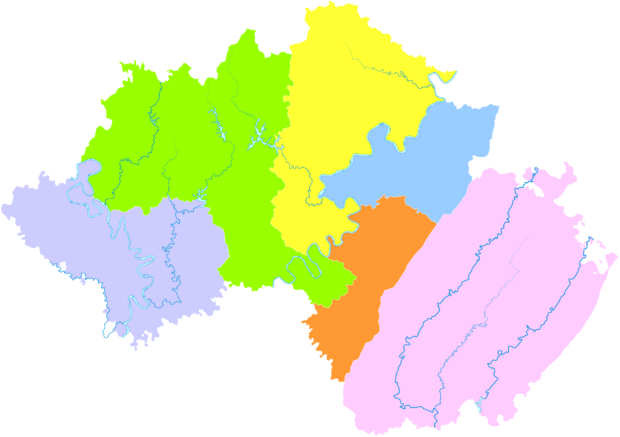
Guang'an city has 1 (sub)city, 3 counties, 87 towns, and 2886 villages within it, a total population of 3,205,476 in 2010 census. None of the districts are urban in character as of 2010, nevertheless, large scale dense urban building projects and even urban rapid transit are nearing completion as of 2019, remaking the urbanscape entirely, and 2010 census data relegated to dated and unreliable.
| Map | |||||
|---|---|---|---|---|---|
| Name | Hanzi | Hanyu Pinyin | Population (2010) |
Area (km2) | Density (/km2) |
| Guang'an District | 广安区 | Guǎng'ān Qū | 858,159 | 1,032 | 832 |
| Qianfeng District | 前锋区 | Qiánfēng Qū | 530,000 | 504 | 1051 |
| Huaying City | 华蓥市 | Huāyíng Shì | 368,000(2015) | 505.6 | 728 |
| Yuechi County | 岳池县 | Yuèchí Xiàn | 778,639 | 1,457 | 534 |
| Wusheng County | 武胜县 | Wǔshēng Xiàn | 585,624 | 966 | 606 |
| Linshui County | 邻水县 | Línshuǐ Xiàn | 704,695 | 1,919 | 367 |
Transport[]
The city lies on the north-south China National Highway 212.
A 9.955 km (6.186 mi), seven station monorail is under construction as part of the planned two line Guang'an Metro. The first line was due to open in 2020 but testing has been delayed and as of June 2021 the line is still now open.
Economy[]
Guang'an's economy is natural resource based. Mineral resources are plentiful and the soil is ideal for agriculture.
Tourism[]
Chinese leader Deng Xiaoping's birthplace and former residence museum is located in Paifang village (牌坊村) in Xiexing town (协兴镇). Guang'an also has beautiful natural scenery including many mountains and gorges designated as parks.
References[]
- ^ "China: Sìchuān (Prefectures, Cities, Districts and Counties) - Population Statistics, Charts and Map".
- ^ "China: Sìchuān (Prefectures, Cities, Districts and Counties) - Population Statistics, Charts and Map".
- ^ 中国地面气候标准值月值(1981-2010) (in Simplified Chinese). China Meteorological Data Service Center. Retrieved 20 October 2018.
| |||||||||||||||||||||||||||||||||||||||||||||||||||||||||||||||||||||||||||||||||||||||||||||||||||||||||||||||||||||||||||||||||||||||||||||||||||||||||||||||||||||||||||||||||||


- Guang'an
- Cities in Sichuan
- Prefecture-level divisions of Sichuan