Sêrxü County
Sêrxü County
石渠县 · སེར་ཤུལ་རྫོང་། | |
|---|---|
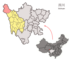 Location of Sêrxü County (red) within Garzê Prefecture (yellow) and Sichuan | |
 Sêrxü Location of the seat in Sichuan | |
| Coordinates: 32°58′44″N 98°06′10″E / 32.9790°N 98.1029°ECoordinates: 32°58′44″N 98°06′10″E / 32.9790°N 98.1029°E | |
| Country | People's Republic of China |
| Province | Sichuan |
| Autonomous prefecture | Garzê |
| Area | |
| • Total | 24,944 km2 (9,631 sq mi) |
| Time zone | UTC+8 (China Standard) |

| Sêrxü County | |||||||
|---|---|---|---|---|---|---|---|
| Chinese name | |||||||
| Simplified Chinese | 石渠县 | ||||||
| Traditional Chinese | 石渠縣 | ||||||
| |||||||
| Tibetan name | |||||||
| Tibetan | སེར་ཤུལ་རྫོང་། | ||||||
| |||||||
Sêrxü County (Tibetan: སེར་ཤུལ་རྫོང་།; simplified Chinese: 石渠县; traditional Chinese: 石渠縣), also known as Sershul, Dzachuka, Serxu, or Shiqu is a county of the Garzê Tibetan Autonomous Prefecture in the northwest of Sichuan Province, China, bordering Qinghai to the west and the Tibet Autonomous Region to the southwest.
Geography[]

Serxu (sershul) County is situated at the northwest corner of Sichuan province, and is also the westernmost county-level division of the province. It is above 25,000 km² et and mainly covered by grasslands. Average level above sea is 4,200 m.
It has an area of over 25,000 square kilometers and is predominantly covered by grasslands used for nomadic herding. The population is around 68,000, 96% of whom are ethnic Tibetan.
By the end of 1997, there was an estimated livestock population of 581,470. These were mainly yaks, sheep, goats, and horses, but there was a small number of pigs. The human population of Shiqu County was approximately 63,400, 96.8% of which were ethnic Tibetans. There were 49,100 herdsmen, representing 77.6% of the population.
Sershul District villages include: Ariksar, Bumser, Changma, Dezhongma, Dzagyel, Geming, Gotsa, Junyung, Jowo, Kabshi, Kilung, Kyewu, Sershul Gompa, Serxu Dzong, Shaksa, Tromsa Genma, Tseboum Soumdo, Tsemkhog, Ombo and Wathul.
Sershul District has several monasteries, including: , Sershul Monastery, , Ariksar, Dzagyel, Changma, Trikar, Kabshi and Jowo; and the Gsumge Mani Stone Castle, a religious complex built out of mani stone tablets.
Demography[]
The population of the district was 62,408 inhabitants in 1999.[1]
There are about 52,660 nomads in the district, i.e. 77,6% of the population.
Climate[]
| Climate data for Sêrxü (1981−2010) | |||||||||||||
|---|---|---|---|---|---|---|---|---|---|---|---|---|---|
| Month | Jan | Feb | Mar | Apr | May | Jun | Jul | Aug | Sep | Oct | Nov | Dec | Year |
| Record high °C (°F) | 12.1 (53.8) |
10.2 (50.4) |
14.8 (58.6) |
17.5 (63.5) |
20.7 (69.3) |
23.1 (73.6) |
23.5 (74.3) |
22.6 (72.7) |
21.7 (71.1) |
19.1 (66.4) |
12.5 (54.5) |
10.0 (50.0) |
23.5 (74.3) |
| Average high °C (°F) | −2.5 (27.5) |
−0.5 (31.1) |
3.1 (37.6) |
6.8 (44.2) |
10.6 (51.1) |
13.7 (56.7) |
15.6 (60.1) |
15.2 (59.4) |
12.7 (54.9) |
7.3 (45.1) |
1.8 (35.2) |
−1.5 (29.3) |
6.9 (44.3) |
| Daily mean °C (°F) | −11.7 (10.9) |
−8.8 (16.2) |
−4.5 (23.9) |
−0.4 (31.3) |
3.5 (38.3) |
7.1 (44.8) |
9.0 (48.2) |
8.1 (46.6) |
5.3 (41.5) |
−0.3 (31.5) |
−7.1 (19.2) |
−11.2 (11.8) |
−0.9 (30.4) |
| Average low °C (°F) | −20.0 (−4.0) |
−16.7 (1.9) |
−11.2 (11.8) |
−6.3 (20.7) |
−2.3 (27.9) |
1.9 (35.4) |
3.4 (38.1) |
2.2 (36.0) |
−0.1 (31.8) |
−5.8 (21.6) |
−14.3 (6.3) |
−19.7 (−3.5) |
−7.4 (18.7) |
| Record low °C (°F) | −37.2 (−35.0) |
−31.8 (−25.2) |
−27.5 (−17.5) |
−15.9 (3.4) |
−11.2 (11.8) |
−6.0 (21.2) |
−4.1 (24.6) |
−7.9 (17.8) |
−10.0 (14.0) |
−20.3 (−4.5) |
−30.3 (−22.5) |
−37.8 (−36.0) |
−37.8 (−36.0) |
| Average precipitation mm (inches) | 6.5 (0.26) |
9.3 (0.37) |
14.2 (0.56) |
25.1 (0.99) |
58.0 (2.28) |
107.0 (4.21) |
114.4 (4.50) |
92.5 (3.64) |
86.2 (3.39) |
42.1 (1.66) |
6.2 (0.24) |
3.7 (0.15) |
565.2 (22.25) |
| Average relative humidity (%) | 45 | 45 | 48 | 54 | 63 | 69 | 70 | 71 | 72 | 67 | 54 | 46 | 59 |
| Source: China Meteorological Data Service Center | |||||||||||||
References[]
- ^ (in English) National Population Statistics Materials by County and City - 1999 Period, in China County & City Population 1999, Harvard China Historical GIS
External links[]
- maps of Sershul County
- Development Projects in Sershul
- (in Chinese) Page descriptive - Google translation
- County Police Bureau
- County News
- photos of Sershul
- County Justice Bureau
- County Buddhism Academy
- County Water Resources Bureau
| County-level divisions |
|   |
|---|---|---|
| Towns and villages |
| |
| Geography |
| |
| Landmarks | ||
This Sichuan location article is a stub. You can help Wikipedia by . |
- County-level divisions of Sichuan
- Garzê Tibetan Autonomous Prefecture
- Sichuan geography stubs