Garzê Tibetan Autonomous Prefecture
Ganzi Prefecture
甘孜州 · དཀར་མཛེས་ཁུལ། | |
|---|---|
甘孜藏族自治州 དཀར་མཛེས་བོད་རིགས་རང་སྐྱོང་ཁུལ་ Ganzi Tibetan Autonomous Prefecture | |
 | |
 Location of Ganzi Tibetan Autonomous Prefecture in Sichuan | |
| Country | China |
| Province | Sichuan |
| Prefecture seat | Kangding |
| Government | |
| • Type | Autonomous prefecture |
| • CCP Secretary | Liu Chengming |
| • Chairman | Xiang Qiu |
| • Governor | Xiao Youcai |
| • CPPCC Chairman | Shu Dachun |
| Area | |
| • Total | 147,681.37 km2 (57,020.10 sq mi) |
| Population (2010) | |
| • Total | 1,091,872 |
| • Density | 7.4/km2 (19/sq mi) |
| Time zone | UTC+8 (China Standard) |
| ISO 3166 code | CN-SC-33 |
| Website | www |
| Garzê Tibetan Autonomous Prefecture | |||
|---|---|---|---|
| Chinese name | |||
| Chinese | 甘孜藏族自治州 | ||
| |||
| Abbreviated as "Ganzi Prefecture" | |||
| Chinese | 甘孜州 | ||
| |||
| Tibetan name | |||
| Tibetan | དཀར་མཛེས་བོད་རིགས་རང་སྐྱོང་ཁུལ་ | ||
| |||
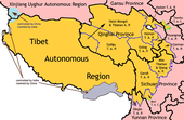
Garzê Tibetan Autonomous Prefecture (Tibetan: དཀར་མཛེས་བོད་རིགས་རང་སྐྱོང་ཁུལ་, THL Kardzé Börik Rangkyongkhül; Chinese: 甘孜藏族自治州; pinyin: Gānzī Zàngzú Zìzhìzhōu) also known as Ganzi — is an autonomous prefecture in the western arm of Sichuan province, China, bordering Yunnan to the south, the Tibet Autonomous Region to the west, and Gansu to the north and northwest. It is sometimes spelled "Kardze" and "Garzin"[citation needed] by non-government sources.
The prefecture's area is 151,078 square kilometres (58,332 sq mi). The population is approximately 880,000, with Tibetans accounting for 77.8% of the total population. The capital city of Garzê is Kangding (Dartsedo).
History[]
Garzê was traditionally part of the historical region of Kham.
During the period of rule by the Republic of China (1912–49), Garzê became nominally part of the province of Xikang, which included parts of former Kham.
In 1930, the Tibetan army invaded Garzê, capturing it without much resistance. However, in 1932, the Tibetan army withdrew after suffering defeats elsewhere at the hands of the warlord of Qinghai, Ma Bufang.[citation needed] Chinese warlord Liu Wenhui reoccupied Garzê, and signed an agreement with the Tibetans formalizing his control of the area east of the upper Yangtze, which corresponds roughly with eastern Kham.[citation needed]
In 1950, following the defeat of the Kuomintang forces by the People's Liberation Army, the area fell within the control of the People's Republic of China. Eastern Xikang was merged with Sichuan in 1955, where Garzê became an Autonomous Prefecture.[citation needed]
Population[]
According to the census of 2000, Garzê had a registered population of 897,239 (population density: 5.94 people/km2).
| nationality | population | proportion |
|---|---|---|
| Tibetans | 703,168 | 78.37% |
| Han Chinese | 163,648 | 18.24% |
| Yi | 22,946 | 2.56% |
| Qiang | 2,860 | 0.32% |
| Hui | 2,190 | 0.24% |
| Naxi | 760 | 0.08% |
| Mongolians | 477 | 0.05% |
| Bai | 292 | 0.03% |
| others | 898 | 0.11% |
Languages[]
Garzê is linguistically diverse, having many variants of Tibetan as well as several Qiangic languages:
- Kangding: Guiqiong, Muya
- Luding County: Muya
- Danba County: rGyalrong
- Jiulong County: Pumi (Southern)
- Yajiang County: Zhaba
- Dawu County: Horpa
- Xinlong County: Queyu
Religion[]
Tibetan Buddhism is historically the predominant religion practiced in Garzê. Some notable Gompas here include:
- Dzogchen Monastery
- Dzongsar Monastery
- Kandze Monastery
- Kharnang Monastery
- Nanwu Si Monastery
- Palpung Monastery
- Sershul Monastery
- Tongkor Monastery
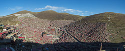
- Larung Gar Buddhist Institute
- Yarchen Gar Buddhist Institute
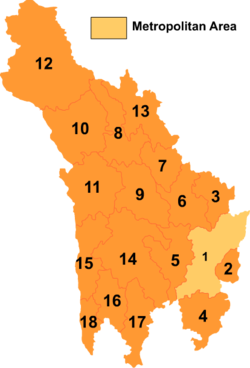
Subdivisions[]
Garzê comprises 1 county-level city and 17 counties:
| Map | # | Name | Hanzi | Hanyu Pinyin | Tibetan | Wylie | Population (2010 Census) |
Area (km2) | Density (/km2) |
|---|---|---|---|---|---|---|---|---|---|
| |||||||||
| 1 | Kangding City | 康定市 | Kāngdìng Shì | དར་མདོ་གྲོང་ཁྱེར་ | dar mdo grong khyer | 130,142 | 11,486 | 11.33 | |
| 2 | Luding County | 泸定县 | Lúdìng Xiàn | ལྕགས་ཟམ་རྫོང་ | lcags zam rdzong | 83,386 | 2,165 | 38.51 | |
| 3 | Danba County | 丹巴县 | Dānbā Xiàn | རོང་བྲག་རྫོང་ | rong brag rdzong | 59,696 | 4,656 | 12.82 | |
| 4 | Jiulong County | 九龙县 | Jiǔlóng Xiàn | བརྒྱད་ཟུར་རྫོང་ | brgyad zur rdzong | 62,133 | 6,766 | 9.18 | |
| 5 | Yajiang County | 雅江县 | Yǎjiāng Xiàn | ཉག་ཆུ་རྫོང་ | nyag chu rdzong | 50,225 | 7,558 | 6.64 | |
| 6 | Dawu County (Daofu County) | 道孚县 | Dàofú Xiàn | རྟ་འུ་རྫོང་ | rta 'u rdzong | 55,396 | 7,053 | 7.85 | |
| 7 | Luhuo County | 炉霍县 | Lúhuò Xiàn | བྲག་འགོ་རྫོང་ | brag 'go rdzong | 46,558 | 4,601 | 10.11 | |
| 8 | Garzê County (Ganzi County) | 甘孜县 | Gānzī Xiàn | དཀར་མཛེས་རྫོང་ | dkar mdzes rdzong | 68,523 | 7,303 | 9.38 | |
| 9 | Xinlong County | 新龙县 | Xīnlóng Xiàn | ཉག་རོང་རྫོང་ | nyag rong rdzong | 50,393 | 8,570 | 5.88 | |
| 10 | Dêgê County (Dege County) | 德格县 | Dégé Xiàn | སྡེ་དགེ་རྫོང་ | sde dge rdzong | 81,503 | 11,025 | 7.39 | |
| 11 | Baiyü County | 白玉县 | Báiyù Xiàn | དཔལ་ཡུལ་རྫོང་ | dpal yul rdzong | 56,290 | 10,386 | 5.41 | |
| 12 | Sêrxü County (Shiqu County) | 石渠县 | Shíqú Xiàn | སེར་ཤུལ་རྫོང་ | ser shul rdzong | 80,834 | 24,944 | 3.24 | |
| 13 | Sêrtar County (Seda County) | 色达县 | Sèdá Xiàn | གསེར་ཐར་རྫོང་ | gser thar rdzong | 58,606 | 9,332 | 6.28 | |
| 14 | Litang County | 理塘县 | Lǐtáng Xiàn | ལི་ཐང་རྫོང་ | li thang rdzong | 69,046 | 13,677 | 5.04 | |
| 15 | Batang County | 巴塘县 | Bātáng Xiàn | འབའ་ཐང་རྫོང་ | 'ba' thang rdzong | 48,649 | 7,852 | 6.19 | |
| 16 | Xiangcheng County | 乡城县 | Xiāngchéng Xiàn | ཕྱག་འཕྲེང་རྫོང་ | phyag 'phreng rdzong | 33,170 | 5,016 | 6.61 | |
| 17 | Daocheng County | 稻城县 | Dàochéng Xiàn | འདབ་པ་རྫོང་ | 'dab pa rdzong | 31,113 | 7,323 | 4.24 | |
| 18 | Dêrong County | 得荣县 | Déróng Xiàn | སྡེ་རོང་རྫོང་ | sde rong rdzong | 26,209 | 2,916 | 8.98 |
References[]
External links[]
| Wikimedia Commons has media related to Ganzi (Garzê) Tibetan Autonomous Prefecture. |
- Official website of Garzê Tibetan Autonomous Prefecture
- Travel information on Garzê TAP towns and villages : along the Northern and Southern Sichuan-Tibet Highways, Tagong (in between both highways), Daocheng and Yading (south of both highways)
- Traditional folk houses in Garze, Sichuan
Coordinates: 30°02′58″N 101°57′44″E / 30.0495°N 101.9623°E

| Authority control |
|
|---|
- Garzê Tibetan Autonomous Prefecture
- Tibetan autonomous prefectures