Tongchuan
This article needs additional citations for verification. (March 2009) |
Tongchuan
铜川市 Tungchwan | |
|---|---|
 | |
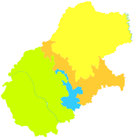
 Location of Tongchuan Prefecture within Shaanxi | |
| Coordinates (Tongchuan municipal government): 34°53′49″N 108°56′42″E / 34.897°N 108.945°ECoordinates: 34°53′49″N 108°56′42″E / 34.897°N 108.945°E | |
| Country | People's Republic of China |
| Province | Shaanxi |
| Municipal seat | Yaozhou District |
| Area | |
| • Total | 3,882 km2 (1,499 sq mi) |
| Population (2010)[1] | |
| • Total | 834,437 |
| • Density | 210/km2 (560/sq mi) |
| Time zone | UTC+8 (China Standard) |
| ISO 3166 code | CN-SN-02 |
| Website | tongchuan |

Tongchuan (simplified Chinese: 铜川; traditional Chinese: 銅川; pinyin: Tóngchuān; lit. 'copper river') is a prefecture-level city located in central Shaanxi province, People's Republic of China on the southern fringe of the Loess Plateau that defines the northern half of the province (Shanbei) and the northern reaches of the Guanzhong Plain.
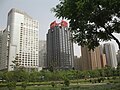
Economy[]
Tongchuan’s main industries are coal, building materials, machinery, textile and chemical and aluminium industry. Pottery and porcelain, with Yaozhou Kiln products are particularly well known. Tongchuan also produces medicines and food products.
Farm products include apples, hot peppers, Chinese prickly ash, garlic, flue-cured tobacco, walnuts and precious Chinese medicine herbs. Apple wine, apple vinegar, apple soft drink which are made of apples and processing products of hot pepper, walnut etc. are well known in China and are exported to Southeast Asia.
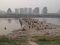
Geography[]
| hideClimate data for Tongchuan (1981–2010 normals) | |||||||||||||
|---|---|---|---|---|---|---|---|---|---|---|---|---|---|
| Month | Jan | Feb | Mar | Apr | May | Jun | Jul | Aug | Sep | Oct | Nov | Dec | Year |
| Average high °C (°F) | 3.1 (37.6) |
6.4 (43.5) |
11.7 (53.1) |
18.7 (65.7) |
23.7 (74.7) |
27.9 (82.2) |
28.8 (83.8) |
27.0 (80.6) |
22.4 (72.3) |
16.8 (62.2) |
10.4 (50.7) |
4.8 (40.6) |
16.8 (62.3) |
| Daily mean °C (°F) | −2.8 (27.0) |
0.5 (32.9) |
5.5 (41.9) |
12.1 (53.8) |
17.2 (63.0) |
21.4 (70.5) |
23.2 (73.8) |
21.7 (71.1) |
16.9 (62.4) |
11.0 (51.8) |
4.3 (39.7) |
−1.3 (29.7) |
10.8 (51.5) |
| Average low °C (°F) | −6.9 (19.6) |
−3.6 (25.5) |
1.0 (33.8) |
6.7 (44.1) |
11.4 (52.5) |
15.7 (60.3) |
18.5 (65.3) |
17.5 (63.5) |
12.9 (55.2) |
6.9 (44.4) |
0.2 (32.4) |
−5.1 (22.8) |
6.3 (43.3) |
| Average precipitation mm (inches) | 6.6 (0.26) |
9.1 (0.36) |
21.1 (0.83) |
31.1 (1.22) |
52.3 (2.06) |
66.8 (2.63) |
115.7 (4.56) |
126.8 (4.99) |
92.9 (3.66) |
49.1 (1.93) |
17.1 (0.67) |
5.6 (0.22) |
594.2 (23.39) |
| Average relative humidity (%) | 57 | 57 | 59 | 59 | 62 | 62 | 74 | 78 | 78 | 74 | 66 | 58 | 65 |
| Source: China Meteorological Administration[2] | |||||||||||||
Administrative divisions[]
Tongchuan city currently comprises 3 administrative county-level subdivisions including 3 district and 1 county.
| Map | ||||||
|---|---|---|---|---|---|---|
| Name | Hanzi | Hanyu Pinyin | Population (2010) | Area (km²) | Density (/km²) | Post code |
| Wangyi District | 王益区 | Wángyì Qū | 200,230 | 162 | 1,236 | 727000 |
| Yintai District | 印台区 | Yìntái Qū | 217,509 | 627 | 347 | 727000 |
| Yaozhou District | 耀州区 | Yàozhōu Qū | 251,860 | 1,572 | 160 | 727100 |
| Yijun County | 宜君县 | Yíjūn Xiàn | 91,160 | 1,476 | 64 | 727200 |
Transportation[]
Tourism[]
There are the ruins of the Yaozhou Kiln, the remains of Palace, and many rare historical relics. The Forest of Stone Sculptures on Yaowang Mountain is a major historical relic under state protection.
References[]
- ^ 铜川市2010年第六次全国人口普查主要数据公报. Tongchuan Bureau of Statistics. 2011-06-09. Retrieved 2020-04-28. Archived 2012-03-25 at the Wayback Machine
- ^ 中国气象数据网 - WeatherBk Data (in Chinese). China Meteorological Administration. Retrieved 2020-04-16.
External links[]
| Wikivoyage has a travel guide for Tongchuan. |
- Tongcuan city Government's official website (in Chinese)


- Tongchuan
- Cities in Shaanxi
- Prefecture-level divisions of Shaanxi