Baihe County
This article needs additional citations for verification. (January 2021) |
Baihe County
白河县 Paiho | |
|---|---|
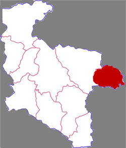 Baihe in Ankang | |
 Ankang in Shaanxi | |
| Country | People's Republic of China |
| Province | Shaanxi |
| Prefecture-level city | Ankang |
| Area | |
| • Total | 1,455 km2 (562 sq mi) |
| Population (2017) | |
| • Total | 215,200 |
| • Density | 150/km2 (380/sq mi) |
| • Rural | 1,870,000 |
| Time zone | UTC+8 (China standard time) |
| Postal Code | 725800 |
Baihe County (simplified Chinese: 白河县; traditional Chinese: 白河縣; pinyin: Báihé Xiàn; lit. 'white river') is located in the southeastern portion of Shaanxi province, China and is the easternmost county-level division under the jurisdiction of the prefecture-level city of Ankang. It is by the eastern part of the Daba Mountains and approaches the Han River on the north. On the east it borders Yun County (Hubei), on the south Zhushan County (Hubei), on the west Xunyang County, and is separated from Yunxi County (Hubei) by a river.[specify]
Baihe is in the north subtropical to warm temperate transitional climatic zone, and is part of the continental seasonal monsoon climate zone. The average temperature is 12.2 to 16.5 °C (54.0 to 61.7 °F), average yearly sunlight 1753.8 hours, average rainfall 787.5 mm (31.00 in), and has 234 to 261 frost-free days each year.
Baihe was historically nicknamed "The Head of Qin and the Tail of Wei." It is a largely rural county, populated mainly by Han Chinese.
Baihe's main outside transportation connection is the Xiangyu Railway.
Administrative divisions[]
As 2019, Longzihu County is divided to 11 towns.[1]
- Towns
|
|
References[]
- ^ "统计用区划代码 www.stats.gov.cn" (in Chinese). XZQH. Retrieved 2021-01-02.
Coordinates: 32°42′51″N 109°55′16″E / 32.71417°N 109.92111°E

- Baihe County
- County-level divisions of Shaanxi
- Ankang