County-level & Sub-prefectural city in Xinjiang, People's Republic of China
Tumxuk Simplified Chinese 图木舒克 Traditional Chinese 圖木舒克 Transcriptions Hanyu Pinyin Túmùshūkè
Uyghur تۇمشۇق
Tumxuk [1] [2] [3] sub-prefecture-level city in the western part of Xinjiang , China. The eastern part of Tumxuk is surrounded by Maralbexi County , Kashgar Prefecture . The smaller western part is near Kashgar .
History [ ] In 1997, Tumxuk City was established.[4]
Geography [ ] It covers an area of 1,927 square kilometres (744 sq mi) and is located 1,222 kilometres (759 mi) southwest of Ürümqi .
Tumxuk Airport is under construction 15 kilometers away and will, upon completion, also serve the nearby counties of Maralbexi and Kalpin .
Demographics [ ] As of 2015, 101,042 (62.0%) of the 163,101 residents of the city were Uyghur , 60,914 (37.3%) were Han Chinese and 1,145 were from other ethnic groups.[5]
Transportation [ ] The city is served by Tumxuk Tangwangcheng Airport and a branch from the Southern Xinjiang railway .
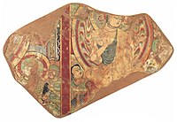
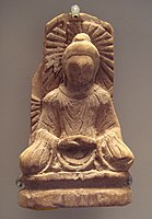
Works of art [ ] Tumxuk (usually spelled Tumshuq) is a well known archaeological site for Serindian art .
Tumshuk. Scenes of the Buddha preaching. 7th century CE
A Serindian art Buddha statue from Tumshuq, Xinjiang . 5th century.
See also [ ] Xinjiang Production and Construction Corps [ ]
^ The official spelling according to Zhōngguó dìmínglù 中国地名录 SinoMaps Press 中国地图出版社 ISBN 7-5031-1718-4
^ The official spelling is "Tumxuk" according to Zhōngguó dìmínglù , 中国地名录 SinoMaps Press 中国地图出版社 ISBN 7-5031-1718-4 ; p. 312.
^ Sui-Lee Wee and Paul Mozur (3 December 2019). "China Uses DNA to Map Faces, With Help From the West" . New York Times . Retrieved 4 April 2020 . CS1 maint: uses authors parameter (link ) ^ 图木舒克市历史沿革 XZQH.org . 18 April 2015. Retrieved 8 April 2020 . 1997年中央为进一步加强新疆生产建设兵团工作,下发中发[1997]17号文件,批准在农三师图木休克垦区(即小海子灌区)设立图木舒克市,为自治区直辖县级市。 ^ 3-7 各地、州、市、县(市)分民族人口数 شىنجاڭ ئۇيغۇر ئاپتونوم رايونى 新疆维吾尔自治区统计局 Archived from the original on 2017-10-11. Retrieved 2017-09-03 .
External links [ ]
County-level divisions of Xinjiang Uyghur Autonomous Region
Prefecture-level cities
Ürümqi Karamay Turpan Kumul / Hami
Sub-provincial
Ili Kazakh
Tacheng 1
Tacheng cityUsu cityShawan cityEmin County Yumin County Toli County Hoboksar Mongol County Altay 1
Prefectures
Aksu
Aksu cityKuqa cityWensu County Xayar County Baicheng County Awat County Kalpin County Xinhe County Wushi County Kashgar / Kashi
Kashgar / Kashi cityMaralbexi / Bachu County Poskam / Zepu County Payzawat / Jiashi Kargilik / Yecheng County Yopurga / Yuepuhu County Yengixahar / Shule County Makit / Maigaiti County Yengisar / Yingjisha County Yarkant / Shache County Konaxahar / Shufu County Tashkurgan Tajik County Hotan / Hetian
Hotan cityHotan County Lop / Luopu County Niya / Minfeng County Gumar / Pishan County Qira / Cele County Keriya / Yutian County Karakax / Moyu County
Autonomous
Changji Hui Bortala Mongol Bayingholin Mongol
Korla cityHejing County Yuli County Hoxud County Qiemo County Bohu County Luntai County Ruoqiang County Yanqi County Kizilsu Kyrgyz
Artux cityAkqi County Wuqia County Akto County
XPCC administered
1 Tacheng and Altay are prefectures within and under the administration of the Ili Prefecture.
Prefectural-level divisions of China Notes: *
Provincial capitals , ★
Sub-provincial cities , ☆
Sub-provincial autonomous prefecture *Sub prefectural-level divisions , ✧Largest cities that will approved by the
State Council
Provinces
Autonomous
Guangxi
*Nanning
Liuzhou Guilin Wuzhou Beihai Fangchenggang Qinzhou Guigang Yulin Baise Hezhou Hechi Laibin Chongzuo Ningxia
*Yinchuan
Shizuishan Wuzhong Guyuan Zhongwei Inner Xinjiang
*Ürümqi
Karamay Turpan Hami Changji (Hui) Bortala (Mongol) Bayingolin (Mongol) Kizilsu (Kyrgyz) ( ☆Ili (Kazakh)
Tacheng Prefecture Altay Prefecture )Aksu Prefecture Kashgar "Kashi" Prefecture Hotan Prefecture * Shihezi * Aral * Tumxuk * Wujiaqu * Beitun * Tiemenguan * Shuanghe * Kokdala * Kunyu * Huyanghe * Tibet
*Lhasa
Shigatse "Xigazê" Chamdo "Qamdo" Nyingchi "Linzhi" Shannan Nagqu Ngari Prefecture
Direct-administered municipalities Special administrative regions
Xinjiang Production and Construction Corps cities
Current Under construction Approved Former
Metropolitan cities of China
Major Metropolitan regions
Jing-Jin-Ji (BJ-TJ-HE) Yuegang'ao Greater Bay Area (GD-HK-MO) Yangtze Delta (SH-JS-ZJ)
Major cities
National Central Cities
Beijing a Chongqing a Guangzhou b2 Shanghai a2 Tianjin a2 Special administrative regions Regional Central Cities
Chengdu b Nanjing b Shenyang b Shenzhen c1 Wuhan b Xi'an b Sub-provincial cities
Changchun b Chengdu b Dalian c2 Guangzhou b2 Hangzhou b Harbin b Jinan b Nanjing b Ningbo c2 Qingdao c2 Shenyang b Shenzhen c1 Wuhan b Xiamen c1 Xi'an b Provincial capitalsPrefecture-level )
Changsha Fuzhou 2 Guiyang Haikou Hefei Kunming Lanzhou Nanchang Shijiazhuang Taiyuan Xining Zhengzhou Taibei 5 Autonomous regional capitals
Hohhot Lhasa Nanning Ürümqi Yinchuan Comparatively large cities
Anshan Baotou Benxi Datong Fushun Jiujiang Handan Huainan Jilin Luoyang Qiqihar Suzhou Tangshan Wuxi Xuzhou Zibo
Other cities (partly shown below)
Prefecture-level capitals
(Inner Mongolia : Ulanhot
Xilinhot )Jiagedaqi 3 , Heilongjiang Enshi , Hubei Jishou , Hunan (Sichuan :Xichang
Kangding Barkam )(Guizhou : Xingyi
Kaili Duyun )(Yunnan : Chuxiong
Mengzi Wenshan Jinghong Dali Mangshi Shangri-La Lushui )(Gansu : Linxia
Hezuo )(Qinghai : Yushu
Delingha )(Xinjiang : Changji
Bole Korla Yining Artux Aksu Kashgar 1 Hotan Tacheng Altay ) Province-governed cities
Jiyuan , Henan (Hubei : Xiantao
Qiánjiang Tianmen Shennongjia )(Hainan 1 : Wuzhishan
Qionghai Wenchang Wanning Dongfang )(Xinjiang - XPCC(Bingtuan) cities : Shihezi
Aral Tumxuk Wujiaqu Beitun Tiemenguan Shuanghe Kokdala Kunyu ) Former Prefecture-level cities
Chaohu , Anhui Yumen ,Gansu Dongchuan , Yunnan Shashi , Hubei (Sichuan : Fuling
Wanxian )(Jilin : Meihekou
Gongzhuling ) Sub-prefecture-level cities
Qian'an, Hebei Manzhouli, Inner Mongolia Erenhot, Inner Mongolia Golmud, Qinghai
Notes
* Indicates this city has already occurred above.
a Direct-administered Municipalities .
b Sub-provincial cities as provincial capitals .
c Separate state-planning cities .
1 Special economic-zone Cities .
2 Open Coastal Cities .3 Prefecture capital status established by Heilongjiang Province and not recognized by Ministry of Civil Affairs. Disputed by Oroqen Autonomous Banner , Hulunbuir, Inner Mongolia as part of it.4 Only administers islands and waters in South China Sea and have no urban core comparable to typical cities in China.5 The claimed province of Taiwan no longer have any internal division announced by Ministry of Civil Affairs of PRC, due to lack of actual jurisdiction. See Template:Administrative divisions of Taiwan instead.
All provincial capitals are listed first in prefecture-level cities by province.
History of Central Asia
Polities
Yamnaya culture Afanasievo culture Sintashta culture Vakhsh culture Bactria–Margiana Archaeological Complex Andronovo culture Saka Pazyryk culture Massagetae Median Empire Achaemenid Empire Macedonian Empire Seleucid Empire Greco-Bactrian Kingdom Yuezhi Xiongnu Kushan Empire Kushano-Sasanians Kidarites Alchon Huns Hephthalites Tocharians Ustrushana First Turkic Khaganate Western Turks Tang dynasty (Anxi Protectorate )Ikhshids Tokhara Yabghus Oghuz Yabgus Second Turkic Khaganate Uyghur Khaganate Abbasid Caliphate Tahirid dynasty Saffarid dynasty Samanids Ma'munids Farighunids Ghaznavids Great Seljuq Empire Ghurid Dynasty Khwarazmian empire Mongol Empire Chagatai Khanate Golden Horde Ilkhanate Sufi dynasty Kart dynasty Timurid Empire Khanate of Bukhara Khanate of Khiva Russian Turkestan Soviet Central Asia Chinese Central Asia Culture
Central Asian art Silk Road Silk Road transmission of Buddhism Serindian art Archaeology
Southern Russia Western China
Kucha Kizil Caves Kizilgaha caves Kumtura Caves Subashi Temple Dunhuang Miran Niya Rawak Loulan Mogao Caves Tumshuq Bezeklik Caves Dunhuang Caves Loulan Miran Khotan Kashgar Mongolia Kazakhstan Kyrgyzstan Uzbekistan Tajikistan Turkmenistan
Cave of Dzhebel Abiward Altyndepe Anau culture Anau Dev-Kesken Gonur Depe Jeitun Konye-Urgench Kutlug Timur Minaret Merv Monjukli Depe Namazga-Tepe Nisa Togolok Ulug Depe Afghanistan
Artifacts