Changji
This article needs additional citations for verification. (May 2020) |
Changji
昌吉市 · سانجى شەھىرى Changki | |
|---|---|
 Location of Changji City (pink) in Changji Prefecture (yellow) and Xinjiang | |
 Changji Location of the city centre in Xinjiang | |
| Coordinates (Changji municipal government): 44°00′52″N 87°16′03″E / 44.0144°N 87.2674°ECoordinates: 44°00′52″N 87°16′03″E / 44.0144°N 87.2674°E | |
| Country | People's Republic of China |
| Autonomous region | Xinjiang |
| Autonomous prefecture | Changji |
| Area | |
| • Total | 7,981 km2 (3,081 sq mi) |
| Population (2003) | |
| • Total | 390,000 |
| • Density | 49/km2 (130/sq mi) |

| Changji | |||||||||||
|---|---|---|---|---|---|---|---|---|---|---|---|
| Chinese name | |||||||||||
| Chinese | 昌吉 | ||||||||||
| |||||||||||
| Uyghur name | |||||||||||
| Uyghur | سانجى | ||||||||||
| |||||||||||
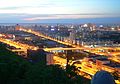
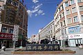
Changji is a county-level city situated about 40 km (25 mi) west of the regional capital, Ürümqi in Northern Xinjiang, China and has about 390,000 inhabitants. It is the seat of Changji Hui Autonomous Prefecture. At the northeast corner of the modern city are the walls and other archaeological remains of the Tang dynasty city, usually referred to as Ancient Changji.
A Federation of Industry and Commerce is at Changji. In the area around Changji crop growing, animal husbandry and oil crop growing are important parts of the economy. Changji is the home of Changji University.
Geography[]
| Climate data for Changji (1981–2010 normals) | |||||||||||||
|---|---|---|---|---|---|---|---|---|---|---|---|---|---|
| Month | Jan | Feb | Mar | Apr | May | Jun | Jul | Aug | Sep | Oct | Nov | Dec | Year |
| Average high °C (°F) | −9.1 (15.6) |
−5.5 (22.1) |
5.6 (42.1) |
19.3 (66.7) |
26.2 (79.2) |
30.9 (87.6) |
32.6 (90.7) |
31.6 (88.9) |
25.6 (78.1) |
15.9 (60.6) |
3.4 (38.1) |
−6.5 (20.3) |
14.2 (57.5) |
| Daily mean °C (°F) | −14.2 (6.4) |
−10.5 (13.1) |
0.5 (32.9) |
12.3 (54.1) |
19.0 (66.2) |
23.8 (74.8) |
25.6 (78.1) |
24.1 (75.4) |
18.0 (64.4) |
9.0 (48.2) |
−1.1 (30.0) |
−11.0 (12.2) |
8.0 (46.3) |
| Average low °C (°F) | −18.4 (−1.1) |
−14.9 (5.2) |
−3.9 (25.0) |
6.1 (43.0) |
12.6 (54.7) |
17.4 (63.3) |
19.4 (66.9) |
17.5 (63.5) |
11.6 (52.9) |
3.8 (38.8) |
−4.6 (23.7) |
−14.5 (5.9) |
2.7 (36.8) |
| Average precipitation mm (inches) | 8.5 (0.33) |
8.3 (0.33) |
11.9 (0.47) |
22.2 (0.87) |
26.3 (1.04) |
22.5 (0.89) |
25.2 (0.99) |
19.7 (0.78) |
15.1 (0.59) |
16.2 (0.64) |
15.0 (0.59) |
11.4 (0.45) |
202.3 (7.97) |
| Average relative humidity (%) | 81 | 79 | 70 | 48 | 45 | 45 | 47 | 46 | 50 | 62 | 77 | 82 | 61 |
| Source: China Meteorological Administration[1] | |||||||||||||
Transport[]
Changji is served by China National Highway 312, the Northern Xinjiang and the Second Ürümqi-Jinghe Railways.
References[]
- ^ 中国气象数据网 - WeatherBk Data (in Chinese (China)). China Meteorological Administration. Retrieved 2020-04-15.
External links[]
| |||||||||||||||||||||||||||||||||||||||||||||||||||||||||||||||||||||||||||


This Xinjiang location article is a stub. You can help Wikipedia by . |
- County-level divisions of Xinjiang
- Populated places in Xinjiang
- Changji Hui Autonomous Prefecture
- Xinjiang geography stubs