Yengisar County
Yengisar County
يېڭىسار ناھىيىسى 英吉沙县 Yangi Hissar, Yingchisha, Yingjisha | |
|---|---|
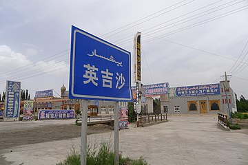
 Signs advertising Yengisar's famous knives. | |
 Location of Yengsiar County (red) within Kashgar Prefecture (yellow) and Xinjiang | |
| Country | People's Republic of China |
| Province | Xinjiang |
| Prefecture | Kashgar |
| Area | |
| • Total | 3,425 km2 (1,322 sq mi) |
| Population (2010)[2] | |
| • Total | 262,067 |
| • Density | 77/km2 (200/sq mi) |
| Ethnic groups | |
| • Major ethnic groups | Uyghur[3] |
| Time zone | UTC+8 (China Standard) |
| Postal code | 844500 |
| Website | www |
| Yengisar County | |||
|---|---|---|---|
| Uyghur name | |||
| Uyghur | يېڭىسار ناھىيىسى[4] | ||
| Literal meaning | New Town County | ||
| |||
| Chinese name | |||
| Simplified Chinese | 英吉沙县 | ||
| Traditional Chinese | 英吉沙縣 | ||
| |||
| Alternative Chinese name | |||
| Simplified Chinese | 新城县 | ||
| Traditional Chinese | 新城縣 | ||
| |||
Yengisar County[5][6][7][8][9][10] (also known as Yangi Hissar); via Mandarin Chinese known as Yingjisha[11][12] (Ying-chi-sha), is a county in the southwest of the Xinjiang Uyghur Autonomous Region. It is under the administration of the Kashgar Prefecture. It contains an area of 3,373 km2 (1,302 sq mi). As of the 2002 census, it had a population of 230,000.
The county seat is the city of Yengisar, a town that is best known among the local Uyghurs for its handmade knives. The finely-tuned skill of knife making used to be passed down among generations in Yengisar,[13] but is slowly dying due to China's strict response to deadly clashes in the Xinjiang region.[14]
History[]
In 1499, Ahmad Alaq seized Kashgar and Yengisar from Mirza Abu Bakr Dughlat.[15]
In 1847 and again in 1857, Kashgar and Yengisar were captured.[16]
In 1882, Yengisar Zhili Ting (英吉沙直隶厅) was created.[17]
In 1913, Yengisar Zhili Ting became Yengisar County.[17]
The Battle of Yangi Hissar took place here in April 1934, when Ma Zhancang led the Chinese Muslim 36th division to attack the Turkic Muslim Uighur forces at Yangi Hissar, wiping out the entire Uighur force of 500 and killing the Emir Nur Ahmad Jan Bughra.[18][19]
In 1955, Barin, Jamaterek and Ujme were transferred from Yengisar County to Akto County.[20]
In September 2017, Horigul Nasir, then 21, was jailed for ten years for allegedly promoting the wearing of head scarves. Her brother Yusupjan Nasir was subsequently demoted from his position as an assistant officer of the Saghan township police office to a security guard at the township's Family Planning Department.[21]
Administrative Divisions[]
As of 2019, Yengisar County included four towns, ten townships, and two other areas:[2][22][23]
Town (بازىرى / 镇)
- (Yingjisha; يېڭىسار بازىرى / 英吉沙镇), (Wuqia, Ulughchat; ئۇلۇغچات بازىرى / 乌恰镇, formerly 乌恰乡), (Mangxin;[24] ماڭشىن بازىرى[25] / 芒辛镇, formerly ماڭشىن يېزىسى / 芒辛乡), (Sahan; 萨罕镇, formerly ساغان يېزىسى / 萨罕乡)
Township (يېزىسى / 乡)
- (Chengguan; شەھەر يېزىسى / 城关乡), [26] (Qiaolepan, Cholpan; چولپان يېزىسى / 乔勒潘乡), (Longfu; لومپا يېزىسى / 龙甫乡), (Setili; سىيىتلە يېزىسى / 色提力乡), (Yingye'er; يېڭىيەر يېزىسى / 英也尔乡), (Kezile; قىزىل يېزىسى / 克孜勒乡), (Tuopuluke; توپلۇق يېزىسى / 托普鲁克乡), (Sugaiti; سۆگەت يېزىسى / 苏盖提乡), (Aigusi; ئەگۈس يېزىسى / 艾古斯乡), (Yigeziye'er; ئېگىزيەر يېزىسى / 依格孜也尔乡 / 依格孜牙乡[27])
Others
- (英吉沙县东风农场), Regiment Dongfeng Farm (兵团东风农场)
Economy[]
As of 1885, there was about 72,700 acres (480,014 mu) of cultivated land in Yengisar.[28]
Demographics[]
| Year | Pop. | ±% p.a. |
|---|---|---|
| 2000 | 213,338 | — |
| 2010 | 262,067 | +2.08% |
| [2] | ||
As of 2015, 297,290 of the 302,542 residents of the county were Uyghur, 25,404 were Han Chinese and 851 were from other ethnic groups.[29]
As of 1999, 97.82% of the population of Yengisar (Yingjisha) County was Uyghur and 1.79% of the population was Han Chinese.[30]
Transportation[]
Yengisar is served by China National Highway 315 and the Southern Xinjiang railway.
Wildlife[]
The city of Yengisar gave its name to Yangihissar gecko (Cyrtopodion elongatum) lizard species, which occurs throughout eastern Central Asia, including Xinjiang and Gansu Province.[1]
Notable persons[]
- Isa Alptekin, Uyghur nationalist
- Erkin Alptekin, 1st President of the World Uyghur Congress
- Arken Imirbaki
- Yulbars Khan
Gallery[]
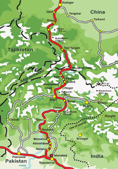
Map of the Karakoram Highway including Yengisar
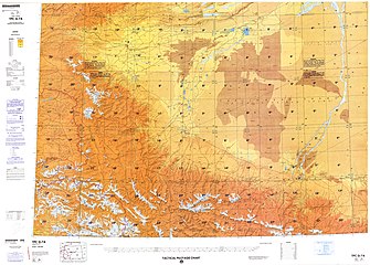
Map including Yengisar (labeled as YING-CHI-SHA) (ACIC, 1969)
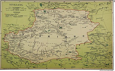
Map including Yengisar (labeled as Yangihissar) (1917)
Map including Yengisar (labeled as YING-CHI-SHA (YANGI HISSAR)) and surrounding region from the International Map of the World (AMS, 1966)

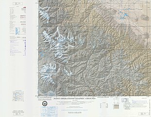
From the Operational Navigation Chart; map including Yengisar (Ying-chi-sha) (DMA, 1980)[a]
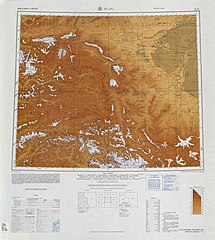
Map including Yengisar (Ying-chi-sha) (DMA, 1984)[b]

Yengisar Knife Factory
Yengisar
يېڭىسار
英吉沙


Notes[]
References[]
| Wikimedia Commons has media related to Yengisar County. |
| Look up Yengisar, Yangi Hissar, or Ying-chi-sha in Wiktionary, the free dictionary. |
- ^ 英吉沙简介. 英吉沙县总面积3425平方公里,辖2镇12乡,耕地面积38.03万亩,有维吾尔、汉、回、乌孜别克、柯尔克孜、哈萨克等,总人口28.4万人(2013年)。. Retrieved 6 March 2020.
- ^ Jump up to: a b c d 英吉沙县历史沿革. XZQH.org. 14 November 2014. Retrieved 5 March 2020.
2000年第五次人口普查,英吉沙县常住总人口213338人,{...}2003年,英吉沙县总面积3420.9平方千米,{...}2010年第六次人口普查,英吉沙县常住总人口262067人,其中:城镇31113人,城关乡13058人,乔勒潘乡11848人,龙甫乡6882人,芒辛乡25746人,色提力乡10424人,萨罕乡30029人,英也尔乡12593人,克孜勒乡24772人,托普鲁克乡13860人,苏盖提乡23280人,乌恰乡42385人,艾古斯乡9371人,依格孜也尔乡5114人,兵团东风农场1592人。
- ^ 1997年英吉沙县行政区划. XZQH.org (in Chinese). 19 November 2010. Retrieved 4 March 2020.
面积4306.5平方千米,人口20.5万,有维吾尔、汉、柯尔克孜、乌孜别克、塔吉克、哈萨克、蒙古等民族,其中维吾尔族占98%,
- ^ يېڭىسار (Variant Non-Roman Script - VS) at GEOnet Names Server, United States National Geospatial-Intelligence Agency
- ^ Ministry of Housing and Urban-Rural Development (2010). 建筑抗震设计规范 [GB50011-2010: Code for Seismic Design of Buildings] (in English and Chinese). Beijing: China Architecture & Building Press. p. 203 – via Google Books.
Yengisar County
- ^ Liangyu, ed. (29 July 2018). "Across China: Xinjiang county builds eco-friendly fruit industry". Xinhua News Agency. Retrieved 4 March 2020.
The farmers benefitted from the transformation. Having harvested 86,000 tonnes of apricots this year, Yengisar County's farmers increased their per capita income by around 1,000 yuan.
- ^ yan, ed. (13 April 2019). "Across China: 1,000-year-old folk craft preserved in Xinjiang". Xinhua News Agency. Retrieved 4 March 2020.
As a staff member of the culture center in Yengisar County, Xinjiang Uygur Autonomous Region, Urziashim performs traditional cloth stamping, a 1,000-year-old Chinese intangible cultural heritage.
- ^ Rahilä Dawut (2009). "Shrine Pilgrimage among the Uighurs". The Silk Road. 6 (2): 58 – via Internet Archive.
The Hazriti Beg mazar, Yengisar, Kashgar prefecture.
- ^ Shohret Hoshur, Joshua Lipes (31 October 2019). "Male Chinese 'Relatives' Assigned to Uyghur Homes Co-sleep With Female 'Hosts'". Radio Free Asia. Retrieved 4 March 2020.
The head of a local neighborhood committee in Yengisar county, who also declined to be named, confirmed that male officials regularly sleep in the same beds or sleeping platforms with female members of Uyghur households during their home stays.
(See: Civil Servant-Family Pair Up) - ^ Yengisar (Approved - N) at GEOnet Names Server, United States National Geospatial-Intelligence Agency
- ^ huaxia, ed. (30 December 2019). "Dawazi performers: chasing dreams on a tightrope". Xinhua News Agency. Retrieved 9 April 2020.
Located in Yingjisha County of Xinjiang, Adili Dawazi Art Heritage Center was founded by Adili Hoshur, a sixth generation Dawazi practitioner known as the "tightrope walking prince". The center currently has 22 members, with the youngest being just 11 years old.
- ^ Yingjisha (Approved - N) at GEOnet Names Server, United States National Geospatial-Intelligence Agency
- ^ Summers, Josh. "The Uyghur Knife and My Visit to Yengisar". FarWestChina.com. Retrieved June 16, 2016.
- ^ Makinen, Julie (September 17, 2014). "For China's Uighurs, Knifings Taint an Ancient Craft". Los Angeles Times. Retrieved June 17, 2016.
- ^ Grousset, Rene (1970), Empire of the Steppes, p. 495
- ^ "JPRS Report China". Foreign Broadcast Information Service. 6 November 1990. p. 42 – via Internet Archive.
- ^ Jump up to: a b 夏征农; 陈至立, eds. (September 2009). 辞海:第六版彩图本 [Cihai (Sixth Edition in Color)] (in Chinese). Shanghai: Shanghai Lexicographical Publishing House. p. 2748. ISBN 9787532628599.
- ^ "Fighting Continues Tungan Troops Still Active in Chinese Turkestan". The Montreal Gazette. 10 May 1934.
- ^ Andrew D. W. Forbes (1986). Warlords and Muslims in Chinese Central Asia: a political history of Republican Sinkiang 1911-1949. Cambridge, England: CUP Archive. p. 123. ISBN 0-521-25514-7. Retrieved 2010-06-28.
- ^ Xie Yuzhong 解玉忠 (2003). 地名中的新疆 (in Chinese). Ürümqi: 新疆人民出版社. pp. 191–92. ISBN 7-228-08004-1.
- ^ Shohret Hoshur, Joshua Lipes (6 November 2017). "Families of Uyghur Police Officers Among Those Detained in Xinjiang's Kashgar". Radio Free Asia. Retrieved 9 April 2020.
- ^ 2019年统计用区划代码和城乡划分代码:英吉沙县 (in Chinese). National Bureau of Statistics of the People's Republic of China. 2019. Retrieved 4 March 2020.
统计用区划代码 名称 653123100000 英吉沙镇 653123101000 乌恰镇 653123102000 芒辛镇 653123103000 萨罕镇 653123200000 城关乡 653123201000 乔勒潘乡 653123202000 龙甫乡 653123204000 色提力乡 653123206000 英也尔乡 653123207000 克孜勒乡 653123208000 托普鲁克乡 653123209000 苏盖提乡 653123211000 艾古斯乡 653123212000 依格孜也尔乡 653123401000 英吉沙工业园区 653123500000 兵团东风农场
- ^ 行政区域. 英吉沙县人民政府门户网站. 24 November 2018. Retrieved 4 March 2020.
英吉沙县辖2个镇、12个乡。英吉沙镇、乌恰镇、城关乡、乔勒潘乡、龙甫乡、芒辛镇、色提力乡、萨罕乡、英也尔乡、克孜勒乡、托普鲁克乡、苏盖提乡、艾古斯乡、依格孜也尔乡。
- ^ Zhao Ruixue, Mao Weihua (13 July 2017). "Textile park tackles poverty in Kashgar". China Daily. Retrieved 9 April 2020.
In the seventh village of Mangxin town in Yengisar county, a stage which was used by residents for dancing is now also used as a place to lock-stitch carpets.
- ^ يېڭىسار ناھىيە ماڭشىن بازىرى ئاققۇش كەنتى بېيىش ماھىرلىرىنى ئالدىن تەرەققىي قىلدۇرۇشقا نۇقتىلىق ياردەم بېرىپ، تېخىمۇ كۆپ نامرات كەنت ئاھالىسىنىڭ نامراتلىقتىن قۇتۇلۇپ بېيىشىغا تۈرتكە بولدى. 中亚之声 (in Uyghur). 28 November 2019. Retrieved 9 April 2020.
يېڭىسار ناھىيە ماڭشىن بازىرى
- ^ Alessandra Cappelletti (2020). Socio-Economic Development in Xinjiang Uyghur Autonomous Region Disparities and Power Struggle in China's North-West. Palgrave Macmillan. p. 243. ISBN 978-981-15-1536-1 – via Google Books.
Qiaolepan/Qolpan Township (乔勒潘乡, چولپان يېزىسى), Village 7 in Yingjisha/Yengihisar County
- ^ “三区分离”使南疆四地州乡村人居环境“换代升级”. State Council of the People's Republic of China (in Chinese). 30 October 2019. Retrieved 9 April 2020.
眼下,位于昆仑山脚下的新疆英吉沙县依格孜牙乡天气逐渐转凉。{...}依格孜牙乡塔克里克艾日克村
- ^ Herold J. Wiens (November 1966). "Cultivation Development and Expansion in China's Colonial Realm in Central Asia". The Journal of Asian Studies. 26 (1): 75. JSTOR 2051832 – via JSTOR.
- ^ 3-7 各地、州、市、县(市)分民族人口数 (in Chinese). شىنجاڭ ئۇيغۇر ئاپتونوم رايونى 新疆维吾尔自治区统计局 Statistic Bureau of Xinjiang Uygur Autonomous Region. 15 March 2017. Archived from the original on 11 October 2017. Retrieved 3 September 2017.
- ^ Morris Rossabi, ed. (2004). Governing China's Multiethnic Frontiers (PDF). University of Washington Press. p. 179. ISBN 0-295-98390-6.
Coordinates: 38°55′33″N 76°10′17″E / 38.92583°N 76.17139°E

- County-level divisions of Xinjiang
- Populated places along the Silk Road
- Kashgar Prefecture