Ürümqi County
This article needs additional citations for verification. (November 2019) |
Ürümqi County
乌鲁木齐县 • ئۈرۈمچى ناھىيىسى | |
|---|---|
 Ürümqi County in Ürümqi City | |
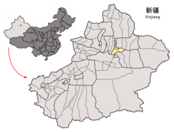 Ürümqi City in Xinjiang | |
| Coordinates: 43°28′19″N 87°24′36″E / 43.4719°N 87.4101°ECoordinates: 43°28′19″N 87°24′36″E / 43.4719°N 87.4101°E | |
| Country | People's Republic of China |
| Province | Xinjiang |
| Prefecture-level city | Ürümqi |
| Time zone | UTC+8 (China Standard) |

| Ürümqi County | |||
|---|---|---|---|
| Chinese name | |||
| Simplified Chinese | 乌鲁木齐县 | ||
| Traditional Chinese | 烏魯木齊縣 | ||
| Postal | Urumtsi | ||
| |||
| Alternative Chinese name | |||
| Simplified Chinese | 迪化县 | ||
| Traditional Chinese | 迪化縣 | ||
| |||
| Uyghur name | |||
| Uyghur | ئۈرۈمچى ناھىيىسى | ||
| |||
Ürümqi County is a county of Xinjiang Uyghur Autonomous Region, Northwest China, it is under the administration of the prefecture-level city of Ürümqi, the capital of Xinjiang. It contains an area of 4,601 km² and according to the 2002 census has a population of 80,000.
According to Xingjian geographic graduate school of Chinese Section College, the geographical midpoint of Asia is located within the county.[1] Urumqi Glacier No.1, the glacier closest to an urban area in the world is also in the county.[2]
References[]
- ^ "43° 40' 52"N 87° 19' 52" E Geographic Center of Asia – The Heart of Asia (亚洲之心) – Xinjiang (新疆), China". confluence.org. Confluence. 2006-06-22. Archived from the original on 2016-06-02. Retrieved 2016-11-10.
- ^ "天山一号冰川". Urumqi County Government. 2017-11-15. Retrieved 2019-11-17.
External links[]
- http://www.wlmqx.gov.cn/ - Ürümqi County official website
| show Authority control |
|---|
This Xinjiang location article is a stub. You can help Wikipedia by . |
Categories:
- County-level divisions of Xinjiang
- Ürümqi
- Xinjiang geography stubs