Karamay
Karamay
克拉玛依市 قاراماي شەھىرى Karamai | |
|---|---|
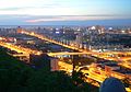
 Karamay River running through the middle of Karamay | |
 Location of Karamay City jurisdiction in Xinjiang | |
 Karamay Location of the city centre in Xinjiang | |
| Coordinates (Karamay municipal government): 45°34′48″N 84°53′21″E / 45.5799°N 84.8892°ECoordinates: 45°34′48″N 84°53′21″E / 45.5799°N 84.8892°E | |
| Country | People's Republic of China |
| Region | Xinjiang |
| Municipal seat | Karamay District |
| Subdivisions | |
| Area | |
| • Total | 7,734 km2 (2,986 sq mi) |
| Elevation | 354 m (1,161 ft) |
| Population (2019)[1] | |
| • Total | 462,347 |
| • Density | 60/km2 (150/sq mi) |
| • Major Nationalities | Han - 74.8% |
| Time zone | UTC+8 (China Standard) |
| Postal code | 834000 |
| Area code(s) | 0990 |
| ISO 3166 code | CN-XJ-02 |
| GDP (2019)[2] | CNY¥ 97.29 billion US $14.1 billion |
| GDP per capita | CNY ¥210,426 US $30,452 |
| - Growth | |
| License Plate Prefix | 新J |
| Website | www |

| Karamay | |||
|---|---|---|---|
| Chinese name | |||
| Simplified Chinese | 克拉玛依 | ||
| Traditional Chinese | 克拉瑪依 | ||
| Hanyu Pinyin | Kèlāmǎyī | ||
| Literal meaning | "Black oil" (in Uyghur) | ||
| |||
| Uyghur name | |||
| Uyghur | قاراماي | ||
| |||
Karamay is a prefecture-level city in the north of the Xinjiang Uyghur Autonomous Region, People's Republic of China. The name of the city comes from the Uyghur language and means "black oil", referring to the oil fields near the city.
Karamay was the site of one of the worst disasters in modern Chinese history, the 1994 Karamay fire, when 324 people, including 288 school children, lost their lives in a cinema fire on 8 December 1994.[3]
History[]
This section needs expansion. You can help by . (July 2020) |
Theater fire in 1994[]
On December 8, 1994, a fire broke out in the Friendship Theater (友谊馆), Karamay. According to official figures, 325 people including 288 school children died. Many teachers were killed while trying to protect and evacuate their students from the building, which lacked adequate safety features. A show was being organized at that moment for a number of local government officials, who managed to escape ahead of the others on spotting the fire, and were afterwards charged with neglecting their duty and received prison sentences of up to five years.
Subdivisions[]
Karamay City has jurisdiction over four districts (区; qū). They are not contiguous as Dushanzi District is located south of the Lanxin Railway and forms an exclave, separated from the rest of Karamay City by Kuytun City. Together with Kuytun City, Karamay City forms an enclave surrounded on all sides by Tacheng Prefecture.
| Map | |||||||
|---|---|---|---|---|---|---|---|
| District | Hanzi | Hanyu Pinyin | Uyghur (UEY) | Uyghur Latin (ULY) | Population (2010 Census) |
Area (km2) |
Density (/km2) |
| Karamay | 克拉玛依区 | Kèlāmǎyī Qū | قاراماي رايونى | Qaramay Rayoni | 261,445 | 3,833 | 68.20 |
| Dushanzi | 独山子区 | Dúshānzǐ Qū | مايتاغ رايونى | Maytagh Rayoni | 69,361 | 400 | 173.40 |
| Baijiantan | 白碱滩区 | Báijiǎntān Qū | جەرەنبۇلاق رايونى | Jerenbulaq Rayoni | 50,422 | 1,272 | 39.63 |
| Orku | 乌尔禾区 | Wū'ěrhé Qū | ئورقۇ رايونى | Orqu Rayoni | 9,780 | 2,229 | 4.38 |

Geography[]
Karamay is located in the northwest of the Dzungarian basin, with an average elevation of 400 meters (1,300 ft). Its administrative area ranges in latitude from 44° 07' to 46° 08' N and in longitude from 80° 44' to 86° 01' E and has a maximal 240 km (150 mi) north–south extent and reaches 110 km (68 mi) in east–west width. It borders Hoboksar Mongol Autonomous County to the northeast, Shawan County to the southeast, Toli County and Wusu to the west and Kuytun to the south.
The naturally available water supply in the Karamay area is limited: it mostly consists of two small rivers (the Baiyang River and the Da'erbute River (达尔不特河) flowing into the Dzungarian Basin from the mountains of its northwestern rim. In addition, the city receives water from the Irtysh River, over the Irtysh–Karamay Canal, which was officially opened in 2008.[4]
A number of natural (Ailik Lake) and artificial (Fengcheng, Huangyangquan) reservoirs are located in Karamay's northeastern Urho District; they all are replenished, directly or indirectly, by water from the Irtysh–Karamay Canal.
Climate[]
Karamay has an extremely continental desert climate (Köppen climate classification BWk), typified by great seasonal extremes in temperature, varying by 43.0 °C (77.4 °F); with long, very hot summers (for its latitude) and long, severely cold winters with brief spring and autumn in between. The monthly 24-hour average temperature is −15.2 °C (4.6 °F) in January and soars to 27.8 °C (82.0 °F) in July and the annual mean is 8.91 °C (48.0 °F), warmer than most places at the corresponding latitude, due to the long summers. Annual precipitation is 119 millimeters (4.69 in) and the summer months record the most rainfall, despite relative humidity levels averaging around 30%. With monthly percent possible sunshine ranging from 37% in December to 71% in September, sunshine is generous, only occurring less than 50% of the time in November and December and the annual average total is 2,694 hours.
| hideClimate data for Karamay (1981–2010 normals) | |||||||||||||
|---|---|---|---|---|---|---|---|---|---|---|---|---|---|
| Month | Jan | Feb | Mar | Apr | May | Jun | Jul | Aug | Sep | Oct | Nov | Dec | Year |
| Record high °C (°F) | 5.8 (42.4) |
12.9 (55.2) |
24.9 (76.8) |
35.6 (96.1) |
39.5 (103.1) |
40.7 (105.3) |
44.0 (111.2) |
42.7 (108.9) |
39.1 (102.4) |
29.9 (85.8) |
20.2 (68.4) |
9.5 (49.1) |
44.0 (111.2) |
| Average high °C (°F) | −11.1 (12.0) |
−6.5 (20.3) |
5.9 (42.6) |
18.9 (66.0) |
26.3 (79.3) |
31.7 (89.1) |
33.6 (92.5) |
31.9 (89.4) |
25.3 (77.5) |
15.2 (59.4) |
3.3 (37.9) |
−7.6 (18.3) |
13.9 (57.0) |
| Daily mean °C (°F) | −15.2 (4.6) |
−10.9 (12.4) |
1.1 (34.0) |
13.1 (55.6) |
20.4 (68.7) |
25.8 (78.4) |
27.8 (82.0) |
26.1 (79.0) |
19.8 (67.6) |
10.4 (50.7) |
−0.5 (31.1) |
−11.0 (12.2) |
8.9 (48.0) |
| Average low °C (°F) | −18.5 (−1.3) |
−14.6 (5.7) |
−3.1 (26.4) |
8.2 (46.8) |
15.1 (59.2) |
20.5 (68.9) |
22.5 (72.5) |
20.9 (69.6) |
14.8 (58.6) |
6.3 (43.3) |
−3.6 (25.5) |
−13.8 (7.2) |
4.6 (40.2) |
| Record low °C (°F) | −35.9 (−32.6) |
−34.3 (−29.7) |
−26.7 (−16.1) |
−10.4 (13.3) |
2.1 (35.8) |
9.0 (48.2) |
12.3 (54.1) |
8.2 (46.8) |
0.3 (32.5) |
−7.7 (18.1) |
−27.2 (−17.0) |
−34.3 (−29.7) |
−35.9 (−32.6) |
| Average precipitation mm (inches) | 4.9 (0.19) |
3.2 (0.13) |
3.5 (0.14) |
8.6 (0.34) |
15.3 (0.60) |
15.9 (0.63) |
23.3 (0.92) |
17.3 (0.68) |
8.3 (0.33) |
7.3 (0.29) |
5.6 (0.22) |
5.8 (0.23) |
119 (4.7) |
| Average precipitation days (≥ 0.1 mm) | 7.7 | 4.5 | 3.9 | 4.4 | 6.1 | 6.9 | 8.1 | 6.9 | 5.0 | 3.7 | 4.4 | 8.9 | 70.5 |
| Average relative humidity (%) | 78 | 75 | 56 | 34 | 31 | 30 | 33 | 33 | 34 | 46 | 63 | 77 | 49 |
| Mean monthly sunshine hours | 140.0 | 159.7 | 220.5 | 258.8 | 291.9 | 295.8 | 302.5 | 298.1 | 266.2 | 221.5 | 139.3 | 99.8 | 2,694.1 |
| Percent possible sunshine | 50 | 55 | 60 | 64 | 64 | 63 | 64 | 68 | 71 | 65 | 49 | 37 | 61 |
| Source: China Meteorological Administration (precipitation days and sunshine 1971–2000)[5][6] | |||||||||||||
Demographics[]
According to the 2010 census, over 80% of Karamay's population are Han Chinese, with minorities such as Uighur, Kazakhs, Mongols and Hui making up the rest. The population of 2010 is 391,008, a rise from the 270,232 of 2000 census. The population density is 50.6 inhabitants per km2.[7] The 2015 population estimate is 401,468.[8]
- Population by ethnicity (2010)[9]
| Ethnicity | Population | % |
|---|---|---|
| Han Chinese | 319,265 | 81.65% |
| Uyghur | 44,866 | 11.47% |
| Kazakhs | 11,620 | 2.97% |
| Hui | 8,238 | 2.11% |
| Mongol | 2,348 | 0.60% |
| Manchu | 754 | 0.19% |
| Xibe | 681 | 0.17% |
| Tujia | 678 | 0.17% |
| Russian | 471 | 0.12% |
| Uzbek | 177 | 0.05% |
| Dongxiang | 133 | 0.03% |
| Kyrgyz | 117 | 0.03% |
| Tajik | 35 | <0.01% |
| Others | 1,625 | 0.42% |
| Total | 391,008 | 100% |
Economy[]
In 1955, one of the largest oil fields in China was discovered there. Since then, the city has grown into an oil-producing and refining center.
In 2008 the GDP reached ¥66.1 billion and GDP per capita reached ¥242,391 (US$34,901), ranking first among 659 cities in mainland China.
Transport[]
- Kuytun–Beitun Railway. There are passenger stations in Karamay itself and in Wuwu New Town (五五新镇街道), south of central Karamay.
- Karamay–Tacheng Railway (under construction as of 2017)
- Karamay Airport
- China National Highway 217
Notable persons[]
- Adil Mijit, comedian
References[]
- ^ "克拉玛依市2019年国民经济和社会发展统计公报" (in Chinese). 25 April 2021. Retrieved 12 March 2021.
- ^ "克拉玛依市2019年国民经济和社会发展统计公报" (in Chinese). 25 April 2021. Retrieved 12 March 2021.
- ^ China aghast at ‘sacrifice’ of 288 pupils, The Sunday Times, May 6, 2007.
- ^ Karamay River Scenic Area
- ^ 中国气象数据网 - WeatherBk Data (in Chinese). China Meteorological Administration. Retrieved 2020-04-15.
- ^ 中国地面国际交换站气候标准值月值数据集(1971-2000年). China Meteorological Administration. Archived from the original on 2013-09-21. Retrieved 2010-05-25.
- ^ "KÈLĀMĂYĪ SHÌ (Prefecture-level City, Xīnjiāng Wéiwú'ĕr Zìzhìqū) Population". City Population.
- ^ "Karamay: Bulletin for the economical and social development in 2015". Archived from the original on February 6, 2017. Retrieved April 18, 2016.
- ^ Stanley W. Toops (August 2012). Susan M. Walcott; Corey Johnson (eds.). Eurasian Corridors of Interconnection: From the South China to the Caspian Sea. Routledge. pp. 65–66. ISBN 978-1135078751.
External links[]
| Wikimedia Commons has media related to Karamay. |
- Government website of Karamay (in Simplified Chinese)
- Map of the City of Karamay


| Authority control |
|
|---|
- Populated places in Xinjiang
- Prefecture-level divisions of Xinjiang