Tacheng
Tacheng
塔城市 · چۆچەك شەھىرى Chuguchak; Tahcheng | |
|---|---|
 "Ruins in Chuguchak" by Vasily Vereshchagin (1869) | |
 Location of Tacheng City (pink) in Tacheng Prefecture (yellow) and Xinjiang | |
 Tacheng Location of the city centre in Xinjiang | |
| Coordinates (Tacheng municipal government): 46°45′06″N 82°59′13″E / 46.7517°N 82.9869°ECoordinates: 46°45′06″N 82°59′13″E / 46.7517°N 82.9869°E | |
| Country | People's Republic of China |
| Autonomous region | Xinjiang |
| Prefecture | Tacheng |
| Area | |
| • Total | 4,007 km2 (1,547 sq mi) |
| Population (2003) | |
| • Total | 160,000 |
| • Density | 40/km2 (100/sq mi) |
| Time zone | UTC+8 (China Standard) |
| Postal code | 834700 |

| Tacheng | |||
|---|---|---|---|
| Chinese name | |||
| Chinese | 塔城 | ||
| |||
| Alternative Chinese name | |||
| Chinese | 缺切克 | ||
| |||
| Second alternative Chinese name | |||
| Chinese | 楚呼楚 | ||
| |||
| Third alternative Chinese name | |||
| Simplified Chinese | 塔尔巴哈台 | ||
| Traditional Chinese | 塔爾巴哈台 | ||
| |||
| Uyghur name | |||
| Uyghur | چۆچەك | ||
| |||
| Kazakh name | |||
| Kazakh | شاۋەشەك Sháýeshek | ||
Tacheng[1] (Chinese: 塔城), as the official romanized name, also transliterated from Mongolian as Qoqak, is a county-level city (1994 est. pop. 56,400) and the administrative seat of Tacheng Prefecture, in northern Ili Kazakh Autonomous Prefecture, Xinjiang.
The city was sometimes called Tarbaghatay or Tarbagatai (Mongolian: 'having marmots') and in European languages as Chuguchak (based on its name in the Mongolian language).[2] The current official Chinese name Tacheng is an abbreviation of "Tarbaghatay City". The current Uyghur name is Qöqäk transliterated from Mongolian.
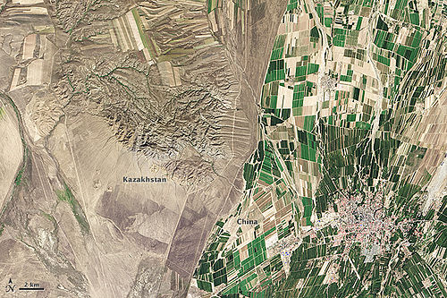
It is located in the Dzungarian Basin, some 10 km (6.2 mi) from the Chinese border with Kazakhstan. For a long time it has been a major center for trade with Central Asia because it is an agricultural hub. Its industries include food processing, textiles, and utilities.
History[]
In the mid-19th century, Chuguchak was considered the most important commercial center of Western China after Ghulja (Yining), being an important center of trade between China and Russia, in particular in tea. The city, surrounded by an earth wall, was the residence of two Qing ambans and had a garrison of some 1,000 Chinese soldiers and 1,500 Manchu and Mongol soldiers.[2]
Chuguchak suffered harshly in 1865, during the fighting between the Qing forces and the Dungan and Uyghur rebels.
Border crossing[]
The Bakhtu border crossing (simplified Chinese: 巴克图口岸; traditional Chinese: 巴克圖口岸; pinyin: Bākètú Kǒu'àn) into Kazakhstan is located 17 km (11 mi) from Tacheng. The checkpoint on the Kazakh side of the border is also known as Bakhty and is located 60 km (37 mi) from Makanchi in East Kazakhstan Province. In April 1962, during the (伊塔事件),[3] over 60,000 Chinese nationals, including around 48,000 Tacheng residents, illegally crossed the Xinjiang–Kazakh SSR border,[3] leading to massive economic loss in Tacheng; the border crossing closed in August of that year.[3] The crossing re-opened on 20 October 1990,[3] and was deemed a "first-class port of entry" (一类口岸) on 14 March 1994.[3] On 1 July 1995, the crossing opened to use by third nations.[3]
Kazakh-Chinese border near Tacheng

Administrative divisions[]
Subdistricts (街道)
- (和平街道), (杜别克街道), (新城街道)
Town (镇)
- (二工镇)
Townships (乡)
- Karakabak (喀拉哈巴克乡), (恰夏乡), Abudula Township (阿不都拉乡), (也门勒乡)
- (阿西尔达斡尔族乡)
Other
- Qiaheji Ranch (恰合吉牧场), Bozidake Farm (博孜达克农场), Woyijiayilao Ranch (窝依加依劳牧场), Tacheng Prefecture Cattle Ranch (塔城地区种牛场), Ye'ergaiti XPCC 162 Corp (叶尔盖提兵团162团), Akeqiaoke XPCC 163 Corp (阿克乔克兵团163团), Wulasitai XPCC 164 Corp (乌拉斯台兵团164团)
Climate[]
Tacheng has a typical Xinjiang cool semi-arid climate (Köppen BSk) that is almost moist enough to be a hot summer humid continental climate (Köppen Dfa), as being on the west side of the Altay Mountains the region receives more winter snowfall than most of Xinjiang.
| hideClimate data for Tacheng (1971−2000) | |||||||||||||
|---|---|---|---|---|---|---|---|---|---|---|---|---|---|
| Month | Jan | Feb | Mar | Apr | May | Jun | Jul | Aug | Sep | Oct | Nov | Dec | Year |
| Record high °C (°F) | 7.6 (45.7) |
9.6 (49.3) |
24.7 (76.5) |
33.2 (91.8) |
34.9 (94.8) |
37.2 (99.0) |
40.3 (104.5) |
41.3 (106.3) |
37.7 (99.9) |
32.0 (89.6) |
20.8 (69.4) |
11.8 (53.2) |
41.3 (106.3) |
| Average high °C (°F) | −4.1 (24.6) |
−2.3 (27.9) |
4.1 (39.4) |
17.0 (62.6) |
23.4 (74.1) |
28.4 (83.1) |
30.8 (87.4) |
29.9 (85.8) |
24.1 (75.4) |
15.0 (59.0) |
4.3 (39.7) |
−2.0 (28.4) |
14.1 (57.3) |
| Daily mean °C (°F) | −10.4 (13.3) |
−8.7 (16.3) |
−1.8 (28.8) |
9.7 (49.5) |
15.9 (60.6) |
20.7 (69.3) |
22.9 (73.2) |
21.6 (70.9) |
15.8 (60.4) |
7.6 (45.7) |
−1.2 (29.8) |
−7.4 (18.7) |
7.1 (44.7) |
| Average low °C (°F) | −15.6 (3.9) |
−14.1 (6.6) |
−7.0 (19.4) |
3.6 (38.5) |
9.2 (48.6) |
13.6 (56.5) |
15.7 (60.3) |
14.1 (57.4) |
8.5 (47.3) |
1.9 (35.4) |
−5.6 (21.9) |
−12.0 (10.4) |
1.0 (33.8) |
| Record low °C (°F) | −33.5 (−28.3) |
−37.1 (−34.8) |
−30.6 (−23.1) |
−12.3 (9.9) |
−3.7 (25.3) |
2.6 (36.7) |
6.2 (43.2) |
4.0 (39.2) |
−4.1 (24.6) |
−13.3 (8.1) |
−31.5 (−24.7) |
−34.7 (−30.5) |
−37.1 (−34.8) |
| Average precipitation mm (inches) | 16.5 (0.65) |
14.4 (0.57) |
15.6 (0.61) |
32.4 (1.28) |
31.7 (1.25) |
24.5 (0.96) |
29.8 (1.17) |
16.3 (0.64) |
14.0 (0.55) |
26.9 (1.06) |
34.3 (1.35) |
25.9 (1.02) |
282.3 (11.11) |
| Average precipitation days (≥ 0.1 mm) | 8.9 | 8.5 | 8.3 | 8.2 | 9.4 | 7.9 | 8.4 | 6.3 | 6.0 | 7.5 | 10.0 | 9.7 | 99.1 |
| Source: Weather China | |||||||||||||
Transportation[]
The Karamay–Tacheng Railway (opened on May 30, 2019) connects Tacheng with Baikouquan Station (百口泉站) on the Kuytun–Beitun Railway in Karamay City. It takes 9 hours from Tacheng to Ürümqi. [4]
Tacheng is also served by the Tacheng Airport with flights to Ürümqi and other cities in Xinjiang.
References[]
This article includes a list of general references, but it remains largely unverified because it lacks sufficient corresponding inline citations. (September 2016) |
- ^ The official spelling according to 中国地名录. Beijing: SinoMaps Press (中国地图出版社). 1997. ISBN 7-5031-1718-4.
- ^ Jump up to: a b Lumley, John (1869), Report by Mr. Lumley, Her Majesty's Secretary of Embassy at St. Petersburgh, on the Tea Trade of Russia, dated May 4, 1867. [Extracted from "Commercial reports" presented to Parliament, July 1867.], p. 73
- ^ Jump up to: a b c d e f 百年口岸——巴克图-塔城市政府门户网 (in Chinese). Tacheng People's Government. 2011-07-20. Retrieved 2020-05-11.
- ^ 穿越“魔鬼风区”的克塔铁路通车 新疆实现所有地州首府通火车. Xinhua. 2019-05-30.
- Khālidī, Qurbanʻali, Allen J. Frank, and Mirkasym Abdulakhatovich Usmanov. An Islamic Biographical Dictionary of the Eastern Kazakh Steppe, 1770-1912. Brill's Inner Asian library, v. 12. Leiden: Brill, 2004.
- Light, Nathan. "Qazaqs in the People's Republic of China: The Local Processes of History". Bloomington, Indiana: Indiana Center on Global Change and World Peace, Occasional Paper No. 22, June 1994. ISBN 1-881157-24-5.
- Light, Nathan. "Kazakhs of the Tarbaghatai: Ethno-History Through a Novel". The Turkish Studies Association Bulletin, 17/2 (1993): 91-102.
- Saguchi Toru. "Kazak Pastoralists on the Tarbaghatai Frontier under the Ch'ing." In: Proceedings of the International Conference on China Border Area Studies. Lin En-hsien [Lin Enxian], ed. Taipei: National Chengchi University, 1985, pp. 953–996.
- Wiens, Herold J. "Change in the Ethnography and Land Use of the Ili Valley and Region, Chinese Turkestan". Annals of the Association of American Geographers, Vol. 59, No. 4. (Dec., 1969), pp. 753–775.
External links[]
| Wikimedia Commons has media related to Tacheng. |
- Map of the City of Tacheng (in Chinese)
- Webpage on the Bakktu border crossing in Xinjiang's Land Ports and Border Trade website


| show Authority control |
|---|
- Populated places in Xinjiang
- China–Kazakhstan border crossings
- Tacheng Prefecture