Guiping
Guiping
桂平市 · Gveibingz Si Kweiping; Sunchow; Sünchow | |
|---|---|
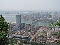
 Guiping, seen from Mt. Xi | |
| Coordinates: 23°24′N 110°05′E / 23.400°N 110.083°ECoordinates: 23°24′N 110°05′E / 23.400°N 110.083°E | |
| Country | People's Republic of China |
| Region | Guangxi |
| Prefecture-level city | Guigang |
| Township-level divisions | 21 towns 5 townships |
| Municipal seat | (西山镇) |
| Area | |
| • Total | 4,074 km2 (1,573 sq mi) |
| Elevation | 50 m (164 ft) |
| Population (2005) | |
| • Total | 1,700,000 |
| • Density | 420/km2 (1,100/sq mi) |
| Time zone | UTC+8 (China Standard) |
| Postal code | 537200 |
| Area code(s) | 0775 |

| Guiping | |||||||||||||||
|---|---|---|---|---|---|---|---|---|---|---|---|---|---|---|---|
| Chinese name | |||||||||||||||
| Chinese | 桂平 | ||||||||||||||
| |||||||||||||||
| Xunzhou | |||||||||||||||
| Traditional Chinese | 潯州 | ||||||||||||||
| Simplified Chinese | 浔州 | ||||||||||||||
| |||||||||||||||
| Zhuang name | |||||||||||||||
| Zhuang | Gveibingz | ||||||||||||||
Guiping (Chinese: 桂平; pinyin: Guìpíng; Jyutping: Gwai3ping4) is a county-level city in eastern Guangxi, China. It is under the administration of Guigang City, located at the confluence of the Qian and Yu rivers, which are the Xi River's primary north and south tributaries, respectively.
Names[]
Guiping was formerly known as Xunzhou. From 1855 to 1861 it was the capital of the rebel state of Da Cheng and was called Xiujing.
Geography and climate[]

Guiping has a monsoon-influenced humid subtropical climate (Köppen Cfa), with short, mild winters, and long, hot, humid summers. Winter begins dry but becomes progressively wetter and cloudier. Spring is generally overcast and often rainy, while summer continues to be rainy though it is the sunniest time of year. Autumn is sunny and dry. The monthly 24-hour average temperature ranges from 12.5 °C (54.5 °F) in January to 28.6 °C (83.5 °F) in July, and the annual mean is 21.58 °C (70.8 °F). The annual rainfall is around 1,680 mm (66 in), and is delivered in bulk (~46%) from May to July, when the plum rains occur and often create the risk of flooding. With monthly percent possible sunshine ranging from 13% in March to 53% in September, the city receives 1,596 hours of bright sunshine annually.
| Climate data for Guiping (1971–2000) | |||||||||||||
|---|---|---|---|---|---|---|---|---|---|---|---|---|---|
| Month | Jan | Feb | Mar | Apr | May | Jun | Jul | Aug | Sep | Oct | Nov | Dec | Year |
| Average high °C (°F) | 16.2 (61.2) |
16.8 (62.2) |
20.1 (68.2) |
25.2 (77.4) |
29.3 (84.7) |
31.6 (88.9) |
32.9 (91.2) |
32.9 (91.2) |
31.5 (88.7) |
28.2 (82.8) |
23.7 (74.7) |
19.4 (66.9) |
25.7 (78.2) |
| Average low °C (°F) | 10.0 (50.0) |
11.3 (52.3) |
14.6 (58.3) |
19.2 (66.6) |
22.7 (72.9) |
24.8 (76.6) |
25.6 (78.1) |
25.4 (77.7) |
23.9 (75.0) |
20.4 (68.7) |
15.6 (60.1) |
11.5 (52.7) |
18.8 (65.8) |
| Average rainfall mm (inches) | 63.9 (2.52) |
84.0 (3.31) |
100.0 (3.94) |
188.7 (7.43) |
297.8 (11.72) |
255.7 (10.07) |
220.6 (8.69) |
184.0 (7.24) |
116.0 (4.57) |
78.7 (3.10) |
53.1 (2.09) |
40.1 (1.58) |
1,682.6 (66.26) |
| Average rainy days (≥ 0.1 mm) | 13.6 | 16.3 | 18.8 | 19.0 | 20.4 | 18.4 | 17.0 | 16.2 | 11.0 | 8.6 | 6.9 | 7.4 | 173.6 |
| Average relative humidity (%) | 79 | 83 | 85 | 84 | 83 | 83 | 80 | 80 | 77 | 74 | 72 | 73 | 79 |
| Mean monthly sunshine hours | 74.9 | 49.4 | 47.6 | 66.5 | 125.4 | 155.3 | 206.8 | 203.4 | 196.7 | 177.2 | 156.4 | 136.1 | 1,595.7 |
| Percent possible sunshine | 22 | 15 | 13 | 18 | 31 | 38 | 50 | 51 | 53 | 49 | 48 | 41 | 36 |
| Source: China Meteorological Administration[1] | |||||||||||||
Administrative divisions[]
Guiping administers 21 towns (simplified Chinese: 镇; traditional Chinese: 鎮; pinyin: zhèn) and 5 townships (simplified Chinese: 乡; traditional Chinese: 鄉; pinyin: xiāng):[2]
Towns:
- (Chinese: 木乐镇)
- (木圭镇)
- (石嘴镇)
- (油麻镇)
- Shepo (社坡镇)
- (罗秀镇)
- (麻垌镇)
- (社步镇)
- (下湾镇)
- (木根镇)
- (中沙镇)
- (大洋镇)
- (大湾镇)
- Baisha (白沙镇)
- (石龙镇)
- (蒙圩镇)
- (南木镇)
- (江口镇)
- Jintian (金田镇)
- (紫荆镇)
- (西山镇)
Townships:
- (Chinese: 马皮乡)
- (寻旺乡)
- (罗播乡)
- (厚禄乡)
- (垌心乡)
See also[]
References[]
- ^ . China Meteorological Administration https://web.archive.org/web/20090716061113/http://cdc.cma.gov.cn/shuju/index3.jsp?tpcat=SURF&dsid=SURF_CLI_CHN_MUL_MMON_19712000_CES&pageid=3. Archived from the original on 16 July 2009. Retrieved 26 February 2011.
{{cite web}}: Missing or empty|title=(help) - ^ 2011年统计用区划代码和城乡划分代码:桂平市 (in Chinese). National Bureau of Statistics of the People's Republic of China. Archived from the original on 19 February 2013. Retrieved 3 January 2013.
External links[]
- Official website (in Chinese)
- Website of the Jintian Uprising
- Xinhua website (in Chinese)
| |||||||||||||||||||||||||||||||||||||||||||||||||||||||||||||||||||||||||||

This Guangxi location article is a stub. You can help Wikipedia by . |
- Guiping
- County-level divisions of Guangxi
- Guangxi geography stubs